English:
----------
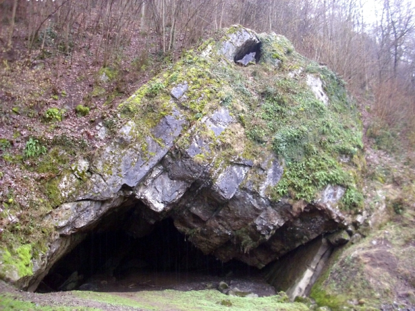
Originally, the river Lomme ran through the cave "Nou Maulin" and it still does from time to time. A dam was build to keep the river out of the cave, but in high water conditions the lower levels of the cave flood totally!
There is another entrance, about 20 m above the original one.
Length: 1606m
Depth: 37 m
The cave is an example of all possible phreatic phenomena that can be seen in caves! The cave is a must for photographers.
Do not enter the cave when waterlevels in the Lomme are high or when the weather is unstable. The cave can flood to the roof!
Caves are formed by various geologic processes.
Types of caves:
- Primary caves are formed at the same time as the surrounding rock.
- Solutional caves are the most frequently occurring caves and such caves form in rock that is soluble.
- Erosional caves are those that form entirely by erosion by flowing streams carrying rocks and other sediments.
To log this cache, you have to answer the following questions via email:
1) Whats the width of the entrance of the cave
2) Whats the usual definition of a cave?
3) Please make a picture, showing you in front of the cave and upload it to your log (see example picture). If possible, of course, we would like to see you discovering the cave, but you don't have to take any risks!
Do not write the answers in your log! You can log directly after you have answered the questions. If an answer is not correct, I will contact you.
Deutsch:
----------
Ursprünglich floss der Fluss Lomme durch die Höhle "Nou Maulin" und von Zeit zu Zeit passiert das auch immer noch. Ein Damm verhindert, das die Lomme die Höhle überflutet, aber bei einem Hochwasser wird die Höhle immer noch überflutet!
Die Höhle hat einen zweiten Eingang, der sich ca. 20m über dem Haupteingang befindet.
Länge: 1606m
Tiefe: 37m
Die Höhle ist ein Beispiel aller möglichen phreatic phenomena, die man in Höhlen finden kann! Für Fotografen ist diese Höhle ein Muss!
Die Höhle sollte nicht betreten werden bei einem hohen Wasserstand der Lomme oder bei zu erwartendem Starkregen. Die Höhle kann dann bis zur Decke geflutet werden.
Höhlen entstehen durch geologische Prozesse.
Man unterscheidet hauptsächlich zwischen folgenden Typen:
- Primäre Höhlen: Darunter versteht man gleichzeitig mit dem sie umgebenden Gestein entstandene Höhlen.
- Sekundäre Höhlen: Darunter versteht man Höhlen, die später als das sie umgebende Gestein entstanden sind.
- Phreatische Höhlen: Diese sind gänzlich von Wasser ausgefüllt.
-Aktiv vadose Höhlen: Diese sind noch regelmäßig von Wasser durchflossen, die Höhlenbildung in diesen Teilen ist noch nicht abgeschlossen.
- Inaktiv vadose Höhlen: Diese sind trocken, hier ist die Höhlenbildung abgeschlossen.
Um diesen Cache zu loggen müsst ihr die folgenden Fragen per Email beantworten:
1) Welche Breite hat der Eingang der Höhle
2) Wie definiert man gewöhnlich eine Höhle?
3) Seit dem 10. Juni 2019 dürfen Fotos bei Earthcaches wieder verlangt werden. Macht ein Foto, das euch vor dem Eingang der Höhle zeigt. Wenn möglich würden wir euch natürlich gerne bei der Erkundung der Höhle sehen, aber ihr sollt aber für diesen Cache keine Risiken eingehen.
Du kannst direkt im Anschluss loggen, falls eine Antwort nicht stimmt, melde ich mich bei dir. Allerdings dürfen im Log nicht die Antworten zu den Fragen stehen - aber das ist ja selbstverständlich.