FORTALEZA DE CHIPUDE (LA GOMERA) EarthCache
FORTALEZA DE CHIPUDE (LA GOMERA)
-
Difficulty:
-

-
Terrain:
-

Size:  (other)
Please note Use of geocaching.com services is subject to the terms and conditions
in our disclaimer.
Edit 17.2.2016:
Due to the new path the old listing co-ordinates were in an area which is now forbidden. Therefore the listing co-ordinates were changed. Thanks to zaviteam for mention it and determine the new co-ordinates.
This Earthcache guides you on top of the Fortaleza de Chipue, the landmark of La Gomera.
Texto espanol abajo! Deutsche Version weiter unten.
English version
Conditions:
Good shoes, enough water, sun protection. Dry waether (by or after rain the rocks are slippery). The walk requires some climbing between the rocks, there is no need for climbing gear. We made it and we are not trained. But don't bring little children.

Geology:
The Fortaleza de Chipude is one of the most characteristic and monumental features in the Gomeran landscape and the Gomeran landmark. It is visible over a distance from Tenerife, La Palma and El Hierro, if the weather conditions are good.
The Fortaleza is a table-Mountain that means that its top is a flat area, a summit platform with over 300 meters in diameter and step walls in every direction. It looks like a fortress (therefore the name) and is only accessible over a small rocky path.
The Fortaleza evolved from the viscous magma of a subvolcano, which could not reach the surface but accumulated underearth lava forming a volcanic plug (German: Kryptodom or Quellkuppe) . This plug caused an extreme build-up of pressure letting the mountain raise but the surface did not burst in an explosive eruption. The magma hardened within the vent of the active subvolcano and erosion removed the surrounding rocks while the erosion-resistand plug of the subvolcano remained, forming the upstanding landscape which is well known as Fortaleza today.

The plug is a tranchiandestic dome and roughty cylindrical in shape. Its walls are almost vertical on all sides. The surrounding canyon-like deep barrancos evolved parallel over the ages, when the soft Gomeran soil (mainly lava and cinder) got washed away to the sea. In its beginnings La Fortaleza was a circular table-top mountain, but due to the erosion of Barranco del Erque, one of the main water drainages in the south of the island, the east of the mountain toppled into the profound canyon, leaving a vertical (even slightly overhanging) tall east face.
Other informations:
The Fortaleza is also a historic side.
The guanchos had several sacrificial altars there (recontructed by now) and the table mountain was arena in the fight between guanchos and conquistadors.
There are a few endemic plants, such as Centaurea (Cheirolophus sataraensis) or Siemproviva (Limonium redivivum).
Watch out for the lizards. They are very nosy.
And by the way: GC2J65J Fortaleza (Traditional cache) by Trüffelschreck
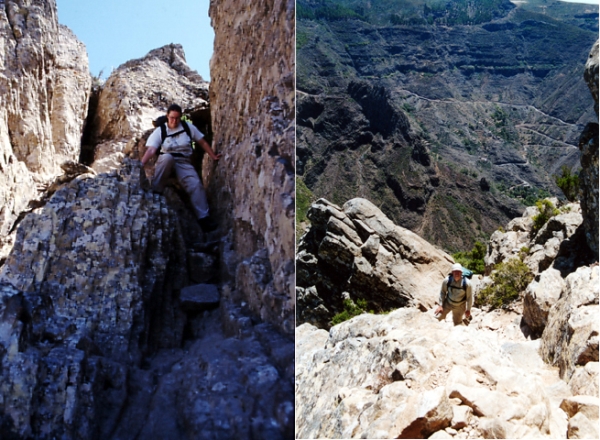
Description of the path:
As the steep walls do not allow a good GPS-signal during the climbing in the wall, I will give you a short description of the path (it is marked white-red):
1.) From the parking area follow the path which branches off at the trafo station.
2.) After leaving Pavon you will find at the right side a farm. After passing by take the path to the right. Soon you will reach reference point 1. Here begins the saddle of the Fortaleza and the trail upwards.
3.) From there you can see allready an eucalytus tree within the wall. The path will lead you to it.
4.) Take the left path upwards and use the rocky stairs.
5.) Now the most difficult passage is the climbing in the steep wall. After that you will reach reference point 2 over a ridge. This is your waypoint for finding the descent.
Your tasks:
To log this Earthcache as a found, you have to e-mail the awnsers of the three following questions to us:
1.) Please meassure the altitude of the Fortaleza with your GPSr, that means the difference between the summit (headcoordinates) and the defined saddle (reference point 1).
2.) Is the summit marked with a tag? What is written on it? 3.) Look around: on top of the Fortaleza you will find a white cross. Meassure the distance between the cross and the summit.
3.) Edit 2.8.21: Foto-upload of you, part of you, your GPSr... in your online-log is required (re-allowed by GC since June 2019)
A picture upload which shows you on top of Fortaleza or during climbing would be great.
You do not have to wait for logpermission, if there is something wrong, I will contact you. Logs without the required e-mail will be deleted. Every team has to send the mail by its own. Do not wait for log-permission, just log your found directly after sending the mail; we will contact you if there is something wrong.
Espanol
I hope this text is understandable. Preconditions:
Buen calzado, bastante agua, proteccion solar. Tiempo seco (por o después llueva las rocas son deslizadizo). La caminata requiere alguno que sube entre las rocas. La caminata no es conveniente para los pequeños niños
Geología:
El La Fortaleza de Chipude es uno de los relieves mas caracteristicos y colosales del paisaje gomero . Es visible sobre una distancia de Tenerife, La Palma y EL Hierro, si las condiciones atmosféricas son buenas.
La Fortaleza es una mesa-Montaña que significa que su cumbre es una plataforma con sobre 300 metros en diámetro y los paredes son empinados en cada dirección. Parece una fortaleza (por lo tanto el nombre) y es solamente accesible sobre una pequeña trayectoria rocosa.
La Fortaleza se desarrolló del magma viscoso de un subvolcano, cuál no podía alcanzar la superficie. Este magmaSe trata de un domo traquiandesitico de forma aproximadamente cilindrica. Este magma causó una acumulación extrema de la presión que dejaba la montaña levantar pero la superficie no estalló en una erupción explosiva. El magma endurecido en la chimenea del subvolcano activo y erosión quitó las rocas circundantes mientras la erosión-resistand domo del subvolcano pararse, formando el paisaje que es bien sabido como Fortaleza hoy.
El domo is tranquiandesitico y de forma aproximadamente cilindrica. Sus paredes son casi verticales en todos los lados. El cerco barrancos desarrollados paralelo sobre las edades, cuando el suelo suave de Gomeran (principalmente lava y escoria) consiguió quitado al mar.
Descripción de la trayectoria:
Pues las paredes escarpadas no permiten una buena GPS-señal durante subir en la pared, le daré una breve descripción de la trayectoria (es blanco-rojo marcado):
1.) De aparcamiento siga la trayectoria que ramifica apagado en la estación del trafo.
2.) Después de irse a Pavon usted encontrará en el derecho una granja. Después de pasar cerca lleve la trayectoria la derecha. Pronto usted alcanzará el punto de referencia 1.
3.) De aqui usted puede ver ya un árbol del eucalytus dentro de la pared. La trayectoria le llevará a ello.
4.) Tome la trayectoria izquierda y utilice las escaleras rocosas.
5.) Ahora el paso más difícil es el subir en la pared escarpada. Usted alcanzará el punto de referencia 2 sobre un canto. Éste es su punto de referencia para encontrar la bajada.
Sus tareas:
Para registrar este Earthcache como "found", usted tiene que email los awnsers de las tres preguntas de siguiente a nosotros:
1.) Por favor mesura la altitud de la Fortaleza con su GPSr, esa significa la diferencia entre la cumbre (listing coordinates) y punto de referencia 1.
2.) Esta una palca a la cumbre (listing coordinates)? ¿Qué se escribe en él? 3.) Mira: encima de la Fortaleza usted encontrará una cruz blanca. Mesura la distancia entre la cruz y la cumbre.
3.) Edit 2.8.21: Foto-upload of you, part of you, your GPSr... in your online-log is required (re-allowed by GC since June 2019)
Una fotografia de usted encima de Fortaleza o durante subir sería grande . Do not wait for log-permission, just log your found directly after sending the mail; we will contact you if there is something wrong.
Deutsche Version
Voraussetzungen:
Gutes Schuhwerk, ausreichend Trinkwasser, Sonnenschutz. Trockenes Wetter (bei oder nach Regen sind die Felsen oft rutschig). Die Wanderung erfordert etwas Kletterei zwischen den Felsen, Kletterausrüstung wird aber keinesfalls benötigt. Wir sind völlig untrainiert und haben es auch geschafft. Für kleinere Kinder ist der Aufstieg nicht zu empfehlen.
Geologie:
Die Fortaleza de Chipude ist eines der besonders characteristischen und monumentalen Punkte Gomeras und sein Wahrzeichen. Sie ist über eine große Distanz bei entsprechendem Wetter auch von La Palma und Teneriffa her sichtbar.
Die Fortaleza ist ein Tafelberg, das bedeutet dass ihre "Spitze" flach ist, nämlich eine große Plattform mit über 300m Durchmesser und steilen Wänden in alle Richtungen. Sie sieht wie eine Festung aus (daher ja auch der Name) und ist nur über einen schmalen felsigen Weg zu erreichen.
Die Fortaleza entwickelte sich aus dem zähflüssigen Magma eines Subvulkans, welches nicht zur Oberfläche gelangen konnte, aber statt dessen unterirrdisch einen Lavastau verursacht hat, der sich zu einer Quellkuppe (Kryptodom) formte. Dise Quellkuppe verusachte einen extremen Druck, der den Berg anwachsen lies, aber die Oberfläche des Berges gab niht in einer Explosion nach, sondern das Magma erstarrte in dem Schlot des aktiven Subvulkans und durch Erosion des umgebenden Gesteins wurde die erosionsrestitente Quellkuppe freigelegt, die dies heute als Fortaleza bekannte Struktur ausmacht.
Die Quellkuppe ist ein Schlot aus Andesit und ungefähr zylindrisch geformt. Ihre Wände sind fast senkrecht nach allen Seiten hin. Die umgebenden Canyon-artigen tiefen Barrancos enstanden im Laufe der Zeit parallel zur Fortaleza, in dem der weiche gomerische Boden (hauptsächlich Asche und Schlacke) ins Meer hin ausgewaschen wurde. Zu Beginn war die Fortaleza fast ein runder Tafelberg, aber aufgrund der schnellen Erosion des Barrancos del Erque, einem Hauptwasserablauf im Süden der Insel, ist ein Teil der östliche Teils des Tafelbergs in den Barranco gestürzt und hat eine senkrechte (teilweise sogar leicht überhängende) Ostflanke geschaffen.
Sonstiges:
Die Fortaleza ist außerdem ein Ort der in der gomerischen Geschichte eine Rolle gespielt hat.
Die Guanchen hatten dort oben mehrere Opferaltare (die mittlerweile nachgebaut sind) und der Tafelberg diente im Kampf der Guanchen gegen die Eroberer den letztgenannten als Zufluchtsort.
Es gibt dort einige endemische Pflanzen wie z.B. Centaurea (Cheirolophus sataraensis) or Siemproviva (Limonium redivivum).
Schaut euch nach den Eidechsen um. Die sind ganz schön neugierig.
Und außerdem: GC2J65J Fortaleza (Traditional cache) by Trüffelschreck
Wegbeschreibung:
Weil die Steilwände keinen guten GPS-Empfang während der Kletterei garantieren, hier eine kurze Wegbeschreibung. Der Wanderweg ist mit einer weiß-roten Markierung versehen.
1.) Nimm den Weg der am Parkplatz (Trafostation) abzweigt.
2.) Nachdem du Pavon verlassen hast, und eine Farm auf der rechten Seite passiert hast, wende dich nach rechts. Du erreichst Referencepunkt 1. Hier beginnt der Rücken der Fortaleza und der Pfad nach oben..
3.) Von hier kannst du einen Eukalyptusbaum in der Wand erkennen, der Pfad führt dich hin.
4.) Nimm dort den nach links ansteigenden Pfad und die steinernden Stufen.
5.) Nun kommt die schwierigste Passage ämlich das Klettern in der Wand. Dann erreichst du Referenzpunkt 2 über einen kleinen Grat. Benutz diesen Punkt um nachher die Stelle für den Abstieg zu finden.
Deine Aufgaben:
Um diesen Earthcache als Found loggen zu können, musst du mir per e-mail die Antworten zu den folgenden drei Fragen senden:
1.) Messe die Höhe der Fortaleza über dem Grund, d.h. die Differenz zwischen ihres "Gipfels" (Listingkoordinaten) und dem Beginn des Anstieges (Referenzpunkt 1).
2.) Gibt es eine Plakette am Gipfel? Was steht darauf? 3.) Schau dich auf der Fortaleza um und du wirst ein weißes Kreuz finden. Messe die Entfernung zwischen dem Kreuz und dem Gipfel.
3.) Pflicht seit 2.8.2021: Foto-Upload von dir, Teilen von dir oder deinem GPS an der Location im Online-Log. Ein hochgeladenes Foto, welches dich auf der Fortaleza oder während der Kraxelei zeigt, wäre schön.
Logs ohne die erforderliche Mail werden gelöscht. Warte nicht auf die Logfreigabe, falls etwas falsch sein sollte, kontaktieren wir dich. Pro Account eine Mail senden! Du kannst sofort loggen, nachdem du die Mail an uns gesendet hast, du musst auf keine Antwort von uns warten.
Quellenangabe:
Informationboard at the Fortaleza
http://en.wikipedia.org/wiki/Volcanic_plug
http://www.summitpost.org/la-fortaleza-de-chipude/386645
Flag counter since 6.4.2011

Additional Hints
(No hints available.)