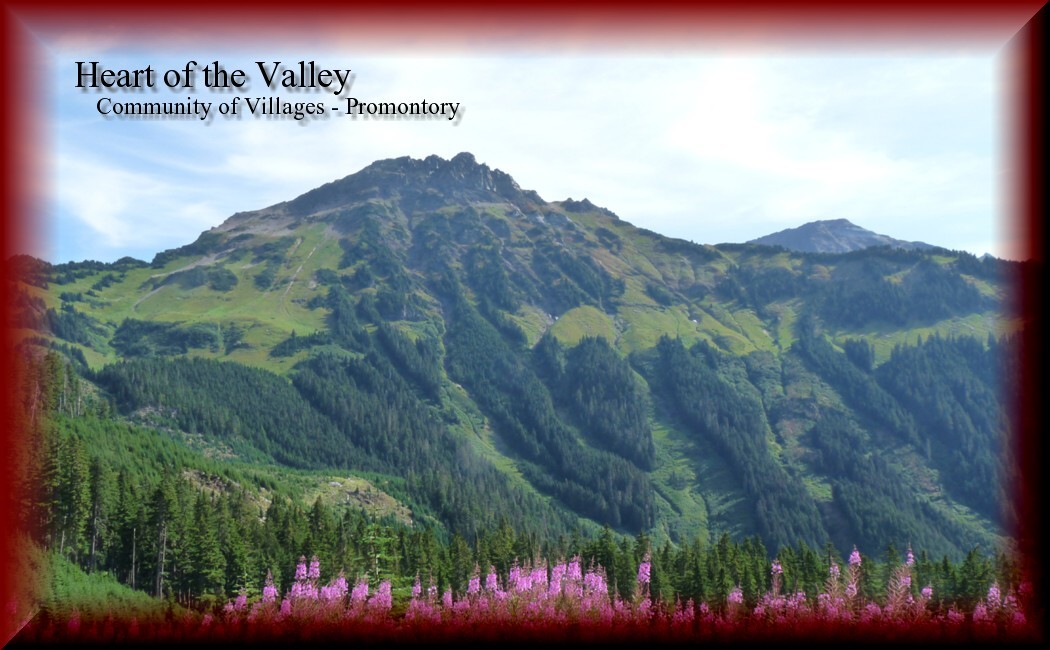
Chilliwack: the "Heart of the Valley" is made up of 14 Villages - In this series of 14 caches we will introduce you to each of those Villages. When you have solved the puzzle for all 14 of the caches your smiley faces will produce the shape of a heart in the Eastern portion of Chilliwack. In each of the 14 caches you will find information which you must record in order to find the Final cache in this series, the "Heart of Hearts" cache.
We hope you enjoy your trip around the area and the cache locations we have selected for this series. Have fun and if possible involve the whole family in solving the puzzles and finding the caches, they are meant to be "family friendly".
The area known as Promontory features rolling land, about 600 feet above the valley floor. In 1886, the first settlers to locate in the area were Edward and Elizabeth Thornton. The Thornton land occupied 263 acres. They developed a mixed farm with produce, cows, chickens, sheep and pigs. Much of the land was heavily forested and required clearing from which the first log shelters were made. At the time, there were no roads and supplies had to be brought in via a trail. Eventually wagon roads were constructed, although it was still a day trip to travel to Chilliwack using wheeled transportation.
Fruit growing was popular on Promontory and George Thornton's fruit orchard was significant to the province of British Columbia. Mr. Thornton, who arrived in Promontory in 1891, worked for the Provincial Government and prepared fruit and vegetable specimens for exhibits at many fairs. These professional exhibits were assembled in large glass containers and involved careful chemical preparation that was mixed in the acid house located on his property. These exhibits promoted British Columbia farmlands by allowing visitors to see, in preserved form, the quality and abundance of the province’s crops.
The Coatham’s arrived in 1900 and developed a family farm from forty-acres of heavily wooded land that required clearing. Step by step, the clearings were planted with several types of fruit trees including early and winter apples, pears, plums, and several varieties of cherries. The Coatham's fruit presentations won prizes at the New Westminster Fair.
Perched atop Promontory Heights sits the one-room Promontory School. Built in 1909 on land donated by Promontory settler Ed Thornton, the school was closed in 1941 but the building remains standing on its original site and now serves as the home for the Hobby Hill Parent Participation Pre-school.
In September 1956, the Township of Chilliwack signed a 20-year lease, permitting the use of the school property by the Promontory Heights Women's Institute. The institute, originally formed in April 1952, was part of the Hopeline District. In 1971, the Women's Institute began a restoration project, with the goal of maintaining the original design and floor plan. Renovations to the former Promontory School were completed in 1974.
With its panoramic view of the Chilliwack Valley, the former Promontory School has been designated a Municipal Heritage site and serves as a fine local example of the one-room school buildings so vital to British Columbia’s rural past.
A few sawmills were located in Promontory. Orion Bowman operated the longest running mill operations in the area. In 1908, he opened his first mill on Upper Promontory Road. In 1912, mill operations were expanded and a shingle mill was added. This new venture was relocated at the foot of Promontory Road and once the Promontory fruit orchards began bearing fruit the Bowman and Sons’ mill started to cut wood for the manufacture of fruit boxes.
Much of the early logging at Promontory was conducted using horses, wagons and skid rows. However, after Bowman’s constructed their second mill site, a narrow gauge railway was built that headed four and a half miles towards the east. Another line headed in a westerly direction and another was later constructed on a southerly route. Rail lines were eventually abandoned as trucks with hard rubber wheels took over logging operations.
Information was obtained from the Chilliwack Museum and Archives Website- Visit them ""Here"
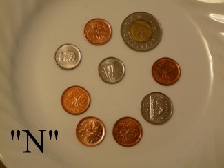
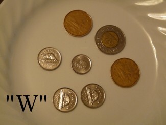
Ok so this is really, really easy for you adults, so let the kids solve this puzzle. Only one person is going to get the FTF on this cache.
The cache is at: N49 07. "N" W121 53. "W"