Dip into the Carboniferous at Poise brook!
Poise Brook Local Nature reserve lies to the NW of Offerton in the borough of Stockport. The nature reserve is a small wooded area through which a little river - Poise Brook - meanders its way to meet up with the River Goyt.
Towards the end of the Carboniferous Period (300-290 million years ago), Britain did not exist above water as it does today – at the time, the whole area was located south of the equator (at a latitude of 5-10o). Scotland was a part of a landmass to the north (Laurussia) and the rest of Britain was largely underwater except for a few island-like landmasses which poked above the sea. To the south lay another landmass called the Armorican micro-continent. Most of Britain was therefore covered by shallow seas or small island-like landmasses; the largest stretching from (what is now) Ireland, across mid-Wales, through the midlands and London and down towards Northern Europe – this landmass was called St George’s land.
 North and south of St George’s land were extensive coastal deltas (a delta is an area where large rivers enter the sea and deposit sediment). These deltas were formed by the large rivers flowing off St George’s land and off the other two larger landmasses and the other smaller islands.
These coastal deltas would fill up slowly with the sediment which was eroding from the landmasses and eventually cause the deltas to become increasingly shallow. This can be seen by a change in the sediment that was being deposited at the time – moving from deeper water silt to coarser sand which is deposited in shallower water.
In the delta backwaters and between the smaller tributaries of the large rivers, huge swamps would form. In these swamps, primitive plants and trees evolved in great numbers and diversity; these included tree-ferns (like Psaronius), which grew to a height of 15 metres, and "scale-trees" (like Lepidodendron), which reached heights of about 30 metres. Insects continued to evolve and thrive in these swamps with huge dragonflies (like Meganeura – with 70cm wingspans) made an appearance together with other large arthropods like giant centipedes. Reptiles (which later evolved into dinosaurs, birds and mammals) also evolved towards the end of the Carboniferous Period. So this was an exciting time for life on earth!
At the same time as the deltas/swamps were filling with sediment – the coastal areas were sinking and occasionally sea levels would rise. When this happened, the sea would cover the fresh-water swamps and kill all the plants. Once the sea water covering the area became deep enough again, the whole process could be repeated: first silt would be deposited by the rivers, followed by sand reducing the depth of the water and when the sea-water was displaced, new fresh-water swamps would form before the whole cycle began again.
Each time the sea would flood the swamps, the vegetation would become covered by silt and sand and the pressure would convert the plant material into coal.
The purpose of this earthcache is to enable cachers to see a layer of coal exposed at the surface – rather than being buried deep underground. In addition, cachers will be able to see the other layers of rock which formed before and after the coal seam was created, when shallow sea-covered deltas deposited silt and sand. (Silt hardens to form a rock called shale and sand hardens to form a rock called sandstone).

A couple of hundred meters before Poise Brook joins the larger River Goyt, there is an exposed section of riverbank which is composed of rock (mainly shale) of Carboniferous age.
Clearly visible and sandwiched between the crumbly layers of grey shale is a dark band of coal bearing rock of Westphalian age (316-314Mybp) (see image above). These coal and other layers have been pushed upwards and are no longer horizontal so they are said to "dip".

In addition to the interest of seeing a coal bearing seam of rock
at the surface, there are also numerous plant fossils to be found.
The fossils are mainly ferns.

This is a nature reserve and it is not permitted to “dig” or “chip” the
fossils out.
Warning Whilst Poise Brook is quite a small river it can become deep and fast-moving after heavy rain. Please use common-sense and time your visit so that the water levels will be low – the drier months would be the best time to visit. To get to the river involves a steep descent down a muddy and slippery bank so sturdy footwear is advised. The land on the opposite side of the river is private property and Earthcachers should not go further than the riverbank.Please do not damage the rock outcrop if you decide to look for fossils – there are obvious fossils in the scree/debris at the base of the rock outcrop so please do not damage this precious location by chipping away at the rock and by digging – the last task is optional so finding a fossil is not essential to claim this cache. Please take care not to damage any of the flora and fauna on your visit and take extra care not to disturb nesting birds during the breeding season.
In order to claim this cache there are a number of tasks which will
need to be completed.
1. Follow the instructions below to make a “Clinometer”. Use your instrument to measure the dip of the Carboniferous rock layers. (Free Smartphone APPS are available which do the same job! E.g. Rocklogger)
2. Estimate the overall height of the riverbank rock face. (Incidentally, the clinometers and a little trigonometry could help you do this very accurately – but that is for another cache).
3. Estimate the thickness of the dark layers combined (there are several small layers which together make up the larger darker band).
4. When sedimentary rocks form, they normally form as horizontal layers. It is clear these layers are nowhere near horizontal - can you explain what might have caused them to lie with such a steep dip?
OPTIONAL TASKS
5. Take a photograph of your home-made clinometers or phone against the dark coal bearing seam of rock (post this on your log).
6. Finally – examine the rock face and some of the scree which has fallen down from the rock-face and you may find fossils.
Take a photo of a fossil alongside your GPRS and post this with your log.
You must NOT include the answers to these
questions in your log – please email the answers to me
separately using the email details associated with my profile
name. Logs without an accompanying email with the answers may be deleted.
***Congratulations to cremedecassis on being the FTF.***
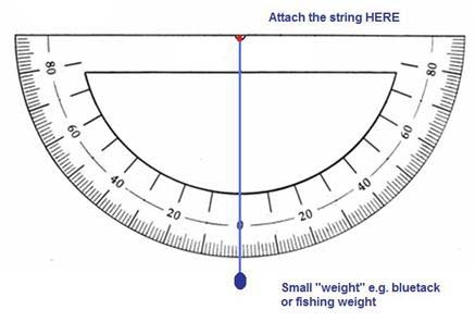
Making a clinometer.
A clinometer is like an inverted school protractor (used for measuring angles) which has a small moving part which allows geologists and surveyors to estimate the angle at which rock layers lie if they are not totally horizontal (this is called the dip).
To make the clinometer –
1. Print out the clinometer below from here(with thanks to Annenberg Learner.org) and glue it onto a piece of sturdy cardboard. Make sure the cardboard is a perfect rectangle with parallel top and bottom sides! (If the base is at an angle it will affect the accuracy of your clinometer).

2. Now waterproof it by covering the clinometer with cling-film or a transparent bag and secure it with tape on the back.
3. Cut a length of string which is long enough to stretch from the centre of the clinometer (there is a small black dot printed at this point) so that it can extend to the scale. Attach the string securely with a drop of glue or using a brass fastener/split pin/tape (the string must be able to swing freely on the attachment point and must rest at zero degrees when on a flat surface).
4. Finally add a small weight onto the end of the string. A small piece of bluetack or a small fishing weight would be perfect.
Using the clinometer.

Rest the clinometer on the rock whose “dip” you want to measure and read off the number against which the string is now lying. See the image above.
Preserving your fossils.
If you are lucky enough to find some fossils at the base of the rock outcrop, then it is important to make the effort to preserve them if you decide to take them away. If you don’t –these fossils will simply dry and crumble away. Please bear in mind that this site is a nature reserve and you must NOT chip at the rock surface or dig for these fossils – it is illegal to do so and the reserve warden will withdraw permission for this earthcache if any damage is done to the site.
A simple way to preserve the fossils is to paint them with
several thin layers of Super PVA glue which can be purchased from a
DIY supplier.
1. Let the fossils dry out for a few days. Put them on some
newspaper and let them dry naturally (do not speed the process up
by heating them or placing them in the sun).
2. Mix equal volumes of super PVA glue and water together to make a
“thin” glue.
3. Use a small paint brush to gently pain the whole piece of rock
onto which the fossil is imprinted.
4. Take great care when painting the fossil itself. You may
actually brush the fossil away!
5. Repeat the process at least one more time so the fossil is
properly sealed and protected.
6. Stick a label on the back of your fossil stating the location
and the date of collection.
7. Post a photo with your log if you like.
My sincere thanks to Stockport council for permission to set-up this earthcache and in particular my thanks to John Rowland (Senior Ranger) for his help and advice
References
British Geological Survey. Stockport England and Wales Sheet 98.
Cleal, C.J. & Thomas, B.A. (1994) Plant Fossils of the British Coal Measures. The Palaeontological Association, London.
McLeish, A. (1986) Geological Science. Blackie and Sons, Glasgow.
Toghill, P. (2003) The Geology of Britain: an introduction. Airlife Publishing.

