A rock Pothole is formed when sand, pebbles and small rocks are
spun around on bedrock by river currents. As they spin they work
like sandpaper and slowly start to grind away the softer rock. The
result looks familiar to a pot hole. Once they are started they can
vary in size from small to very large depending on the size of the
bedrock and the amount of time the river current is strong enough
to push the rocks.
The action of the rocks swirling around in the pothole literally
just "drills" down into the bedrock. In the process the stones and
pebbles wear away at themselves as well as the bedrock until they
are small enough to get out of the hole and they are replaced by
other pebbles until the hole fills in or a stone breaks through the
downstream side of the pothole.

You can only expect to find potholes in rivers that have rocky
beds, and most commonly only rivers where the rock is uniform, for
example, limestone, granite or lava. Potholes do not form in rivers
whose beds are covered with pebbles, silt or mud, so do not look
for them in any lowland river.
Geologists recognize two kinds of potholes in bedrock channels
-- vertical and lateral.
Vertical potholes formed on rock surfaces that were at one time
part of the channel's rock floor. These potholes are now exposed
because that portion of the channel has been raised above the
active river. Vertical potholes can be several meters deep and
across. Viewed from the top, they are almost round and plunge
nearly vertically into the rock. If you clear the hole of its
accumulated debris, you might see at the bottom spoon like
depressions separated from each other by water-smoothed ridges.
Vertical potholes in Bedrock Rivers are thought to be formed by
tight bundles or vortices of water during highly turbulent flood
flow. These vortices pack a lot of energy and literally drill into
the rock, sculpting it into smooth, attractive shapes. This
observation allows us to conclude that the river was so shallow
that the vortices brought on by the flood had touched bottom.
The second kind, lateral potholes, tell very different stories.
These potholes cut into the rocky sides of channels or into sides
of rocks that stuck out of the channel as mini-islands. Lateral
potholes appear lopsided, having rounded down-stream ends and
narrowing upstream ends, somewhat resembling the shell of a garden
snail. This asymmetry tells the direction of former flow.
Lateral potholes commonly have an overhanging part and have
shallow, simple basins, in contrast to the complex chambers of
vertical potholes. Lateral potholes, once considered remains of
broken vertical potholes, formed near the river's surface, where
rock, water and air meet, instead of at the river bottom.
Example of Pot Holes 
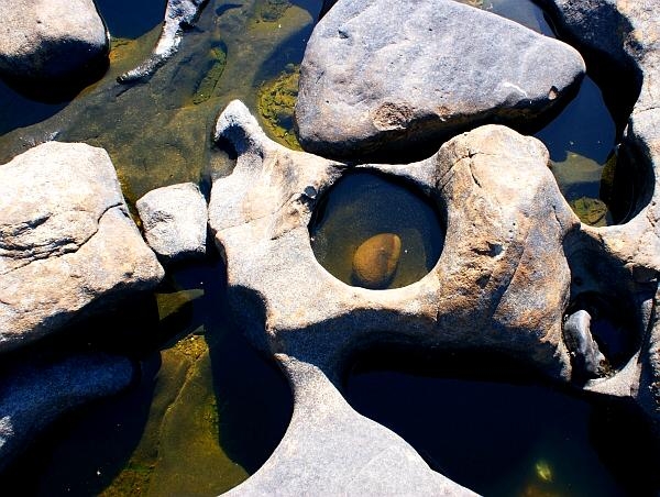
At the posted coordinates you will find 2 pot holes; a large one
and a small one with a small stream of water separating them.
To log this cache you must:
#1 - Measure the width of the large swirl hole and the small swirl
hole. (top of the holes only)
#2 – Note if there are any rocks or pebbles in the swirl hole
the day you visited. If so, describe the size and texture.
#3 – What kind of rock is the swirl hole on? (limestone,
granite or lava)
#4 – Which type of Swirl holes/Potholes are these? (Vertical
or Lateral)
 |
CONGRATULATIONS
TO
HawaiianNinja, MSWahoo, PiscesNAries & SCGeoNinja on the
FTF!! |
|
| I have earned GSA's highest level: |
 |