Rocky
Mountain (RM) Off Road Series (ORS) #17: Iron
Chest
A series by:
Team Red
Rubicon.
This cache is the last of six caches in
the #17 series of Rocky Mountain off-road caches located along the
difficult Iron Chest Trail. The Iron Chest Trail starts out
about 20 miles south-west of Buena Vista near the cool little ghost
town of St. Elmo. This trail is a challenge even for most
modified vehicles with a short section of large loose rocks right
at the beginning of the trail and a long section of shelf road on
the way to the Iron Chest Mine (a full trail description is
included below).
Cache Information
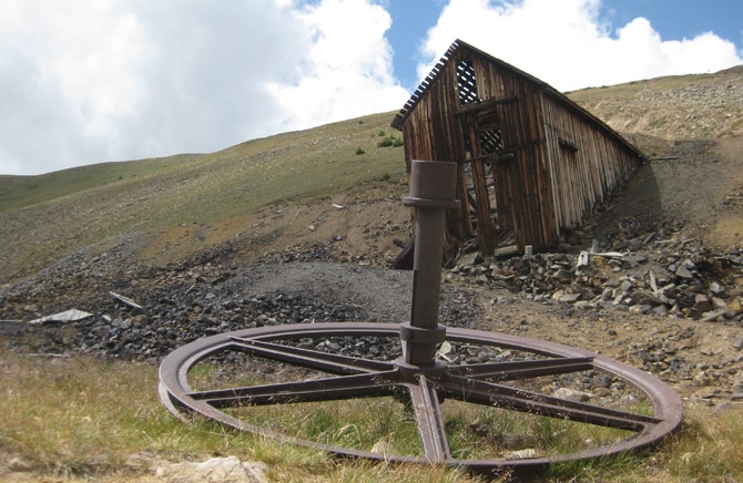
Have fun checking out
the Iron Chest Mine at the end of the trail.
RM Off Road Series #17
Compete Cache Listing
1.
TRR Rocks It
2.
How's Your Aspen
3.
View Time
4.
Hangin On the Shelf
5.
Alpine Moss
6.
Iron Chest Mine
Trail
Information
Rating/Description
Iron Chest is one of several trails that originates from the
Hancock Pass trail. The trailhead is close to the start of the
Hancock Pass Trail near the cool little ghost town of St. Elmo on
the east side of Tincup pass. The trail starts out with a
bang with a difficult rock garden right at the beginning. The
rock garden is about a quarter mile long and is covered with large
loose rocks. Since the rocks are loose, this part of the
trail is constantly changing. After the rock garden is an
easier section through the trees and then a long section of narrow
shelf road before the Iron Chest Mine. You will reach the
12,000 foot Iron Chest Mine at N38 40.332 W106
20.996.
This trail is
rated difficult and will require a modified, highly capable 4WD
vehicle with good ground clearance.
It is also a good idea to have skid plates
because of all of the rocks at the beginning.
The trail is rated a 6 (easiest routes) to 8
(most difficult routes) out of 10 on the traildamage
website. Disclaimer: You need to decide for
yourself if it is safe to make the trip in your vehicle and if you
have any doubts, don't do it.
To get to the trailhead, head south on US
285 from Buena Vista. Turn right on CR-162 at N38 44.396 W106
05.044 and travel approximately 16 miles to the trailhead for the
Hancock Pass trail at N38 42.349 W106 20.411. Head up the Hancock
Pass Trail to the trailhead for Iron Chest at N38 42.141 W106
20.787. The return route for the Iron Chest trail is
back down the mountain the way you came up.
Note: All coordinates in
the above description are included on the waypoint list on
the first cache page.
Winter
Months
Because this trail is at a relatively high elevation, it is not
accessible in the winter months. Iron Chest is generally
accessible to off road vehicles from early to mid July though mid
October although conditions can vary greatly from year to
year.
Time/Distance
The trail is 3 miles from the start at the trailhead to Iron Chest
Mine. The trail can be run in 3-4 hours if you don't make
many stops, but make sure you leave a bunch of extra time to have
lunch on the trail, find the caches and to do some exploring.
To reach the trailhead from the Denver area takes about 2.5 to 3
hours so leave the house early.
Trail
Waypoints
See waypoint list on the
first cache page.