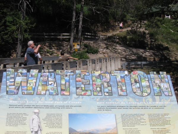
Waterton Lakes National Park is situated in the Southwest corner of Alberta and shares a boundary with Glacier National Park U.S.A and British Columbia. In fact, if you do some exploring in Waterton you will be able to find a location where you can stand with one foot in Canada and one foot in United States of America at the same time.
Waterton Lakes National Park has an area of 505 square kilometers (195 square miles), and is composed of mountains, valleys, plains, lakes and rivers. The highest mountain peak in the park is Mt. Blackiston, at 2940 m (9645 ft). From this height, elevations descend heading northeast to 1524m in the foothills, and 1051m in the northeast corner of the park. The rocks for these mountains were formed many millions of years ago, but most of the present day land forms are a result of glacial activity, water and wind. These mountains abruptly turn into gently rolling hills, and prairie. This sharp contrast is the premise for the park slogan “where the mountains meet the prairies.”
Many people traveling in the Rockies remark on how different the mountains of Waterton Lakes National Park appear. Most are struck by the vivid colours of the rock, especially the reds and the greens. The spectacular scenery is based on unique geological processes. Learning how and when the rocks were formed, uplifted and eroded adds a new dimension to our mountain views.
Layer upon layer of sand, silt, clay and iron-rich mud were buried, compressed and cemented to form sandstone, shale and limestone. Some deeply buried layers were changed (metamorphosed) by additional pressure and heat. For example, shale changed to argillite (red and green rocks) and limestone to dolomite.
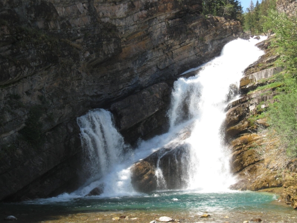
The co-ordinates will take you to Cameron Falls, which is located right in the community of Waterton. These falls are also the site of the oldest rock in the entire Canadian Rocky Mountain range! Precambrian bedrock dating over 1.5 billion years (1,500 million years) old has become exposed and is visible near the falls. This is one of many examples of Waterton Park's amazing geology.
• A series of seas covered North America, the last about 70 million years ago. Waterton's rocks formed in a sea that existed over 1500 million years ago. Evidence of this ancient seabed is provided by fossilized ripple marks, mud cracks and algal colonies.
• The collision between the North American continental plate moving west over an oceanic plate began about 150 million years ago. It mainly affected the Waterton/Glacier area about 75 million years ago. These plate movements created the folded, faulted Rocky Mountains.
• In Waterton, the main movement was a single, flat-lying thrust sheet originating about 100 km/65 miles southwest of their present position. Starting about 75-85 million years ago, it began moving northeast as a unit, sliding over younger 70 million year old Cretaceous rock. This more or less horizontal movement ended about 35-45 million years ago.
• Most rocks seen in the park are sedimentary, some of which have been slightly metamorphosed (changed); a small percentage are igneous.
• Red rocks are shaly siltstones usually argillite - with less than 3% oxidized iron; green are also argillite - with unoxidized iron; these rocks were formed from sediments laid on the bottom of an ancient sea.
• Black rock is an intrusive magma sandwiched between bands of white marble (super-heated limestone) called the Purcell Sill.
• The light-colored layers that you see at Cameron Falls (white, buff, light brown) are limestone and a similar rock called dolomite (in which some calcium has been replaced by magnesium). These rocks form cliffs and steep slopes because they resist erosion better then the crumbly argillites.
To claim this cache go to the posted co-ordinates and find the answers to the following questions and e-mail them to me:
PLEASE DO NOT POST YOUR ANSWERS IN YOUR LOG
1) Roughly how many distinct layers of rock can you see to the right of the falls?
2) Give an approximation of the height of Cameron Falls.
3) In what year did the Western Oil and Coal Company drill an exploration well near Cameron Falls and what was its production rate?
Feel free to take a picture of yourself at the posted co-ordinates and submit it if you like.
ANY FOUND LOGS THAT DO NOT MEET THE LOGGING REQUIREMENTS WILL BE DELETED