PT
Esta cache pertence a um conjunto de três caches que mostram os
antigos caminhos rurais que durante centenas de anos serviram as
povoações destas regiões remotas do Douro.
EN
This cache is part of a three set caches that shows the ancient
rural paths that for hundred of years served this rural comunities
of the Douro region.
PT
Dicas e Informações:
- Esta cache não é tão fácil como as Moitas nem tão dificil quanto
Pestebes. O ponto de partida para cada uma das três caches ficam a
poucos metros uns dos outros, por isso o automóvel poderá ficar
estacionado na berma da estrada e explorar a zona a pé.
- A primeira coordenada mostra o inicio do trilho. As coordenadas
devem ser introduzidas pela ordem dada de modo a seguir pelos
percursos correctos.
- Seguir sempre pelos caminhos rurais (não entre em propriedade
privada) e quando houver encruzilhadas seguir na direcção das
coordenadas dadas.
1º ponto (inicio do trilho):
N 41° 02.983 W
08° 02.699
Introduzir a coordenada seguinte e seguir nessa direcção.
2º ponto:
N 41° 03.265 W
08° 02.510
Seguir pelo caminho superior à estrada na direcção da coordenada. O
caminho é bastante intuitivo, a sua largura é sempre a mesma devido
à passagem durante centenas de anos dos carros de bois que eram
utilizados nos campos.
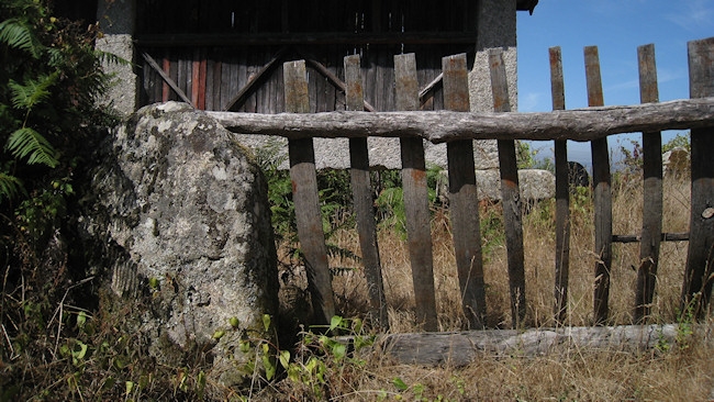
3º ponto: Cache
N 41°
03.(418+N) W 008° 02.(426+N)
Para calcular a coordenada da cache, verificar o número de tábuas
verticais da cerca.
Na foto são visiveis 9 tábuas. Pegar nesse número e somar à
coordenada indicada.
Se o número de tábuas verticais fossem 16 então seria:
N 41°
03.(418+16) W 08° 02.(426+16)
N 41° 03.434 W 08° 02.442
EN
Informations and Tips:
- This is not the easiest or the hardest of the LostTracks series.
The start point for each one of this three caches are few meters
away from one another, so you can leave your automobile in the road
and visit all of them.
- This first coordenate shows the beginning of the trail. The
coordenates should be introduced by the given order so you follow
the correct path.
- Always walk in the rural paths (don't enter privat property) and
in the crosspaths follow the given coordenates.
1st stage (trail start):
N 41° 02.983 W
08° 02.699
Introduce the following coordenate and follow that direction.
2nd stage:
N 41° 03.265 W
08° 02.510
Follow the upper trail in the direction of the coordenate. The path
is very intuitive, it has always the same width. For hundred of
years oxen cars molded the way to the fields.
3st stage: Cache
N 41°
03.(418+N) W 008° 02.(426+N)
To calculate the final coordenate, check the number of vertical
planks on the fence.
In the photo are visible 9 planks. Get that number and sum up to
the to the given coordenates.
If the number of planks were 16 then the coordenates would
be:
N 41°
03.(418+16) W 08° 02.(426+16)
N 41° 03.434 W 08° 02.442
Rz pvzn qb crarqb (qb gnznaub qr hzn crffbn) whagb nb pnzvaub. (aãb rfgá ab zheb)
Ba gur gbc bs gur ovt ebpx (jvgu gur fvmr bs n crefba) arkg gb gur cngu. (vg'f abg va gur jnyy)