Dolinen in Heidelberg EarthCache
-
Difficulty:
-

-
Terrain:
-
Size:  (other)
Please note Use of geocaching.com services is subject to the terms and conditions
in our disclaimer.
Deutsch
Earthcache Dolinen in Heidelberg
Eine Doline ist eine runde oder elliptische Senke in Karstgebieten. Karstgebiete sind unterirdische und oberirdische Geländeformen in Karbonatgesteinen, die durch Verwitterung und Auswaschung entstanden sind. Der Durchmesser der Dolinen kann von 2 bis 200 Metern oder mehr und die Tiefe von 2 bis über 300 Meter reichen.
Dolinen entstehen, anders als Erdfälle, durch Lösungsvorgänge an der Erdoberfläche. Durch den Kontakt mit Wasser findet ein Verkarstungsprozess statt. In deren Verlauf bilden sich Klüfte, Schlote und Hohlräume unterschiedlicher Größe.
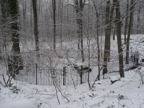
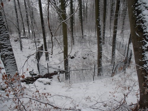
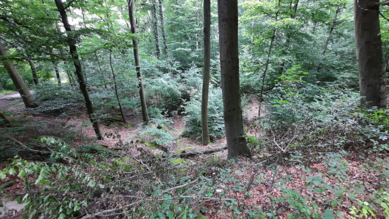
Im Wald oberhalb des Heidelberger Stadtteils Emmertsgrund befinden sich Dolinen am Dolinenweg. Sie sind als Naturdenkmale in das Naturdenkmal der Stadt Heidelberg eingetragen.
Die Besonderheit ist hier, dass sie sich im Bereich von Buntsandsteinformationen befinden. Normaler Weise finden sich solche geologischen Gebilde nur in reinen Karstgebieten. Diese Dolinen befinden sich aber im Oberen Muschelkalk (Nodosus-Kalke, mo 2) und sind von diluvialem Löß überdeckt. Entstanden sind sie durch Gips- und Steinsalzauswaschung im Mittleren Muschelkalk.
Besuche zwei der Dolinen an den angegebenen Stationen (Station 1: N 49° 22.185 E 8° 42.538, Station 2: N 49° 22.210 E 8° 42.463). Beantworte die in der Logfreigabe angegebenen Fragen.
Vor einiger Zeit gab es an Station 1 den Traditional Cache “Erdfall“ (GCX0VP). Der ist allerdings leider inzwischen archiviert.
Logfreigabe
Vor Ort findest du eine Informationstafel. Informiere dich hier und zusätzlich über das Internet über diese geologische Besonderheit. Beantworte folgende Fragen und schreibe mir die Antworten über den GC-Nachrichtendienst oder per Email-Nachricht:
1. Beschreibe den Unterschied zwischen einer Doline und einem Erdfall.
2. Wann wurde der Erdfall als Naturdenkmal ausgewiesen? (Siehe Tafel)
3. Beschreibe die Form der größeren Doline an Station 1. Welche Tiefe hat sie in etwa (von der oberen Wegkreuzung aus gesehen)?
4. Schreite die Doline am oberen Weg ab. Wie viele Meter misst du dabei?
5. Gehe nun zum Wegpunkt 2. Schreite die kleinere Doline auf dem Weg der Länge nach ab. Welche Länge hat die Doline?
6. Mache ein Foto von dir oder einem persönlichen Gegenständen an den Koordinaten oder in unmittelbarer Nähe des Earthcaches. Das Foto muss eindeutig ein Eigenes und vor Ort aufgenommen worden sein. Dein Gesicht kann zu sehen sein, muss es aber nicht. Achte darauf, dass die Antworten nicht durch das Foto zu beantworten sind.
Du kannst loggen sobald du die Antworten abgeschickt hast ohne auf eine Antwort zu warten. Falls damit etwas nicht stimmen sollte, melde ich mich bei dir. Logs ohne korrekte Beantwortung der Fragen und ohne Foto werden gelöscht.
Du kannst auch gerne einen Favoritenpunkt vergeben, wenn du den Earthcache interessant fandest. Darüber würde ich mich sehr freuen.
English
Earthcache dolines in Heidelberg
A doline is a circular or elliptical depression in karst areas. Karst topography are underground and aboveground landforms in carbonate rocks, which are formed by the weathering and leaching. The diameter of the dolines can range from 2 to 200 meters or more, and the depth of 2 to about 300 meters.
Dolines occur unlike sinkholes by solution processes at the surface. By contact with water, there occur karst processes. The formation of crevices, chimneys and cavities of different sizes is the result in this process.
In the forest above the district Emmertsgrund ot the city of Heidelberg dolines are located on the path Dolinenweg. They are registered as natural monuments in the natural monument of the city of Heidelberg.
The special feature is that they are in the range of red sandstone formations. Such geological formations normaly can be found only in pure karst areas. These dolines are located but in the Upper limestones (Nodosus limestones, mo 2) and are covered by diluvial loess. They are caused by the washout of gypsum and rock salt.
Visit two of the dolines at the specified stages (stage 1: N 49 ° 22.185 E 008° 42.538, stage 2: N 49° 22.210 E 008 ° 42.463). Answer the questions listed in the log permission.
Some time ago at stage 1 there was the traditional cache “Erdfall“ (GCX0VP). In the meantime unfortunately it is archived.
Requirements for claiming this Cache
At the given coordinates you will find an information board. Find out more about this geological feature here and online. Answer the following questions and write me the answers via the GC message service or by email:
1. Describe the difference between a doline and a sinkhole.
2. When was this collapse protected as a natural monument? (See board)
3. Describe the shape of the larger sinkhole at station 1. What is the approximate depth (as seen from the upper crossroads)?
4. Step off the sinkhole on the upper path. How many meters do you measure?
5. Now go to waypoint 2. Step down the smaller sinkhole along the length of the path. What is the length of the sinkhole?
6. Take a photo of yourself or a personal item at the coordinates or in the immediate vicinity of the earth cache. The photo must be clearly your own and taken on site. Your face can be seen, but does not have to. Make sure that the answers cannot be answered by the photo.
You may log directly after sending the answers to me. You don't have to wait for my answer. If something should be completely wrong I will contact you. Logs without answering the question and the picture will be deleted.
You can give a favorite point to this earthcache if you want to. I would be very happy.
Additional Hints
(Decrypt)
[de] Sbgb resbeqreyvpu
[en] Cubgb erdhverq