Welcome to the Al's Trail Series!

This is a series of caches along Al's Trail in Newtown, CT.
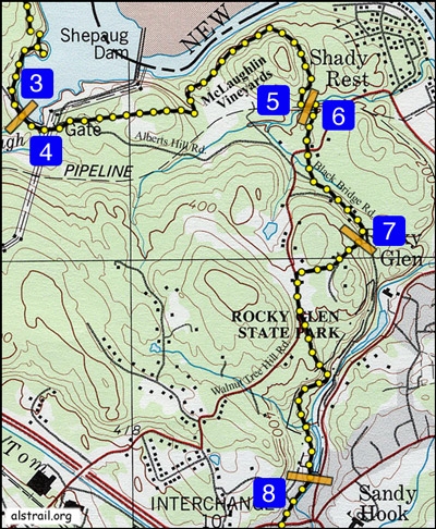
Al's Trail is 10.7 mile trail through a greenway in Newtown that winds its way through a state forest, a state park, town forests, town open space and private property. Along the way one can see eagle roosting areas, a family-owned vineyard, abandoned gold and feldspar mines, steep rock cliffs, and one of Connecticut's best trout streams. The trail is divided in seven sections (between orange bars):
- Upper Paugussett
- McLaughlin Vineyards
- Black Bridge Road
- Rocky Glen
- Dayton Road
- Pootatuck River
- Deep Brook
This cache is on the Black Bridge Road segment and is actually located on the Knott's Memorial Trail Preserve which is a Newtown Forest Assocation property. See waypoints for the best parking (see Blue Box #6). You need to bring your own pen.
For more information see the following link: Black Bridge Road
Also see the Newtown Forest Association link Knott's Memorial Trail
Congratulations to:
Maddog1973 on FTF!
Madcat2018 on FTF!
Gaborik10 on number 100!