About Tanna
Tanna (sometimes spelled Tana) is an island of Vanuatu. It is 40 km (25 mi) long and 19 km (12 mi) wide, with a total area of 550 km² (212 sq mi). Its highest point is the 1,084 m (3,556 ft) summit of Mount Tukosmera in the south of the island.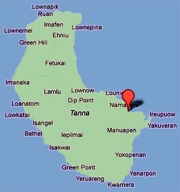 In the east, northeast of the peak, close to the coast, is where Siwi Lake was located until mid April 2000 when, following unusually heavy rain, the lake burst down the valley into Sulphur Bay, destroying the village with no loss of life. It is the most populous island in Tafea Province, with a population of about 20,000, and one of the more populous islands in the country. Isangel, the provincial administrative capital, is on the west coast near the island's largest town of Lénakel. Mount Yasur is an accessible active volcano which is located on the southeast coast.
This Earthcache
The islands that make up Vanuatu sit above a tectonic subduction zone where the Indo-Australian plate is subducting under the New Hebrides plate. This interaction between the tectonic plates is the reason for the volcanic nature of the Vanuatu islands, including the present activity at Mt Yasur, a few kilometres to the south east of these hot springs. The plates move at an average of 1 to 10cm per year and the subduction zone has produced 15 earthquakes greater than 7.0 magnitude since 1976.
The very same geological forces that keep Mt Yasur erupting and putting on pyroclastic displays and lava fountaining, are those that cause the heating of the water that flows from the springs at Sulphur Bay.
Heat from the magma beneath Mt Yasur radiates through the bedrock and heats the spring water deep beneath the island before it percolates upwards where it surfaces along the stretch of river where this earthcache is located.
Hot springs are also present elsewhere around the area, including some very hot ones used by the villagers that outside visitors are not permitted to view (due to land disputes) and also some at Port Resolution.
For a small fee the local villagers will guide you to these hot springs, and you will be able to undertake the tasks required to complete this earthcache. The published coordinates will take you to a section of riverbed amongst a number of hot springs. There are a number of easily locatable and accessible hot springs in the vicinity.
Logging Requirements
To claim a find on this earthcache, please complete the tasks outlined below. Answers to the questions should be emailed to the cache owner and not mentioned in your online log.
1. Locate at least three springs in this area, and as close to the source of each as possible, measure the temperature of the water (in degrees Celsius).
2. For each of the springs used for task 1, take a reading of their coordinates using your GPS unit.
3. Explain what you believe is the reason for different hot springs, in this relatively small area, producing water at different temperatures.
4. Name at least 3 uses of water from the hot springs by the villagers.
5. (Optional) Please take a photo of the river and/or a spring including your GPS unit, and post this with your log online.
You can log this cache straight away after you have emailed your answers to the cache owner, no need to wait for confirmation. Please include the name of this earthcache in the email - you'd be surprised how many people forget. Also, when contacting us with answers, if you want a reply, please include your email address. Any problems with your answers we'll be in touch.
Happy Earthcaching!!!
 Jykk€ & Katjuusa