As an earthcache, there is no “box” or
“container” to discover. Rather, with this cache, you
discover something about the geology of the area. For more info
about Earth Caches take a look at www.earthcache.org
On arrival at GZ,
welcome to the live showing of "An Oxbow in the
Making"......However, I wouldn't suggest you wait around
for the end of the show as it may take a
while!
From looking at the maps and aerial photo of
the area, I would suggest that in this area the ox bow isn't
completely natural and there has been a man made attempt to
straighten the river.

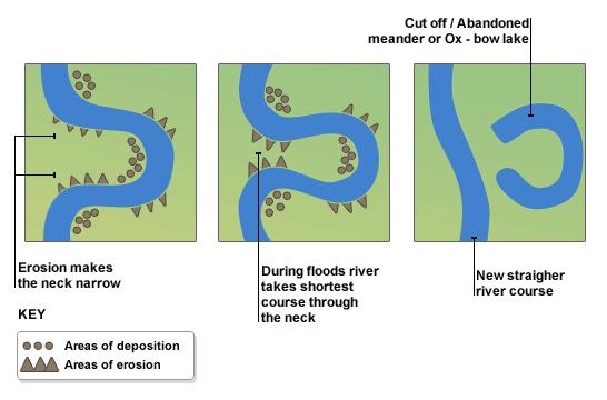
An Oxbow lake is a crescent-shaped land
formation usually caused by flowing water of a stream or river. A
river will flow in the direction of least resistance and will start
to meander. Deposition occurs on the convex bank (the smaller
radius). Lateral erosion and undercutting occur on the concave bank
(the greater radius.)
The continuous deposition on the convex bank
and erosion of the concave bank of a meandering river causes the
formation of a very pronounced meander with two concave banks
getting closer. The narrow neck of land between the two neighboring
concave banks is finally cut through, either by lateral erosion of
the two concave banks or by the strong currents of a flood. When
this happens, a new straighter river channel is created thus
cutting off the meandering loop. When deposition finally seals off
the cutoff from the river channel, an Oxbow lake is formed. The
process occurs over a time scale from a few years to several
decades.
An animation of a meandering stream
forming an Oxbow can be seen at HERE
LOGGING
REQUIREMENTS
Do NOT post your answers in your log
or your log will be
deleted!
To log this EarthCache one must submit to me
through my profile the answers to the following questions:
1. What is the distance between the river bank and the upstream
edge of this Oxbow crescent?
2. Observe what is happening at the downstream end of the Oxbow,
and tell me what and why?
3. Which bank of the Oxbow, inner crescent or outer crescent has
the highest elevation & why is there a difference in
height?
4. (Optional) Please post a photo of your GPS unit with the Oxbow
in the background.

Doyboyz amazing Photo at
GZ
Well done on the FTF to Milvus
Milvus

