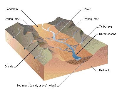
Lam Tsuen Valley.
The Lam Tsuen Valley is one of the largest river valleys in Hong
Kong. It is about 6 km long, and up to 1 km wide. The valley is
characterised by mostly flat land, which to this day is in use for
agriculture.
The main river is the Lam Tsuen River, which starts near
Kadoorie Farm in the south-west end of the valley, running
north-east before turning south-east and later east towards Tai Po
where it drains in the Tolo Harbour. There are numerous other
streams in this valley that feed Lam Tsuen River.
Origin of the floodplain.
A floodplain comes into existence when a river fills up an
existing valley with sediments. The river usually has a well
defined, often meandering path in the valley, depositing sediments
on the rest of the terrain only during floods. Not all such rivers
flood: mature rivers have deposited so much sediment that only in
extreme cases they can flood their valley, or the local climate has
changed in a manner that the current river has far less water than
they used to have. Natural levees may also form. Besides, Lam Tsuen
River has been extensively modified to prevent erosion of its
banks, and to prevent floods.
Lam Tsuen Valley is also characterised by river terraces. These
are formed when a river continues to erode its bed below the
existing floodplain, usually when there is a change in base level
(see below) or when the land is raised. Subsequent events may leave
multiple terraces. This cache highlights one of these terraces, in
this case a tributary that carved its bed into a higher level
terrace of Lam Tsuen River. This smaller stream has created its own
floodplain here.
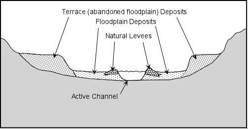
Base level.
Base level is defined as the level below which a river can not
erode. The general base level is sea level: a river can never go
below sea level. Local base levels exist as well, such as lakes
caused by (natural) dams, or highly resistant rock formations a
river has to run over, often causing a waterfall on the other side.
The base level of a tributary is usually the local level of the
river it drains into.

Base level changes for the Lam Tsuen river include changes in
sea level, and a major realignment of the river: it used to turn
north and run via what is now Fanling, but prehistoric changes in
the terrain forced the river to change to its modern course, which
is shorter and as such allows for a lowering of the river bed in
the Lam Tsuen Valley.
The cache.
The listed coordinates bring you to a vantage point highlighting
the floodplain and terraces from a tributary. It is located in a
mostly agricultural area, with many still active farms. Waypoints
WP1 and WP2 are en-route to the listed coordinates, you may want to
check out those first. On the way there walking from Lam Kam Road
depending on your route you will notice a few sudden terrain level
changes, this are the terraces. WP1 and WP2 are on either side of
the same floodplain, you cross the stream en-route between
them.
At the listed coordinates you are standing on the edge of a
terrace (do not leave the path - don't worry if GPS tells you to,
just ignore it). It gives you a good vantage point: to the east is
the old floodplain at the level you are standing on, to the west is
the floodplain of a tributary. A little further you can see another
embankment, that's the other side of the tributary's floodplain.
Some houses are built up there.
Logging tasks.
- At GZ: estimate the height difference between your level
and the floodplain below, and estimate the width of the floodplain.
Realise that this floodplain has been carved out by the small
stream you cross between WP1 and WP2.
- At WP1: next to the path you see a man-made retaining
wall. This wall was built with stones found nearby, built well
before the era of shotcrete. The stones in this wall are typical
river stones. Describe the stones, and why their shape is typical
for stones found in the lower reaches of a river.
Getting there.
Take bus 64K from Tai Po Market Station or Tai Wo Station
(direction Yuen Long), or from Yuen Long Station or Kam Sheung Road
Station (direction Tai Po Market), get off at San Tsuen, and walk
east along Lam Kam Road to She Shan Road. Or take minibus 25K from
Tai Wo Station, ask the driver to get off at She Shan Road.
Walk about 200m along She Shan Road (heading south) before
turning right on the concreted footpath towards WP1.
Final notes.
At no place you need to leave the footpaths. If GPS guides you
off the path, then that's just inaccuracy.
The cache is located in one of the most rural areas of Hong
Kong, where farming is still a way of life for many people. Walking
around this area shows you how our vegetables look like before they
arrive on your plate. Do look at them, but respect the farmer's
property and do not trespass on their fields.
Send your answers to the above questions to me by personal
message, do not post answers in the log. Logs with answers will be
removed without prior notice.
The most exciting way to learn about the Earth and its processes
is to get into the outdoors and experience it first-hand. Visiting
an Earthcache is a great outdoor activity the whole family can
enjoy. An Earthcache is a special place that people can visit to
learn about a unique geoscience feature or aspect of our Earth.
Earthcaches include a set of educational notes and the details
about where to find the location (latitude and longitude). Visitors
to Earthcaches can see how our planet has been shaped by geological
processes, how we manage the resources and how scientists gather
evidence to learn about the Earth.