A walking tour of Newport, The City by the Sea. This cache will bring you to several interesting locations within Newport, giving you a little background and history of America's First Resort.
At each intermediate stage you will need to collect a number that will be used to determine the location of the cache container. The information necessary will be in BOLD text below, after the brief history lesson for each location. You can visit the stages in any order, but the listed order is the most efficient if you are walking. Parking is difficult (to put it mildly) in the summer, so I strongly recommend you find a parking spot, and do the cache by foot. From Stage 1 to the final is about 1.5 miles. Depending on where you park and the route you take, it may be more.
The final cache is a film can sized container and is located at:
41 29.abc
71 18.def
Have fun, and enjoy your tour.
Stage 1 - The Liberty Tree
Almost 240 years ago William Read donated a small triangular plot of land at Thames and Farewell streets to William Ellery and other Sons of Liberty, shortly after the successful struggle to force the British Parliament to repeal the Stamp Act.
The donation was welcomed not for the land, but for the tall buttonwood tree, known as "The Liberty Tree," that stood on the property.
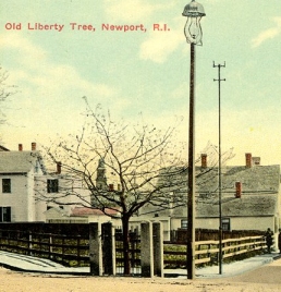
Sometime in 1765, the Sons of Liberty began rallying at the tree to protest the hated Stamp Act that the colonists believed was unjust taxation and the latest case of oppression by Parliament. Andrews said the nearby Common Burying Ground was a backdrop for mock funerals the protesters held for "Liberty." The group also hung in effigy people who defended the British policies.
The Liberty Tree remained a gathering point during the decade leading up to the Revolutionary War, Andrews said. The local tree became such an icon for the independence movement that Gen. Thomas Gage ordered it be cut down some time after the British occupied Newport in December 1776, Andrews said.
In celebration of victory in war, the departure of the British and the signing of the Treaty of Paris, Newport residents planted an oak tree at the site in 1783 that became the second Liberty Tree. It flourished until the early 1860s, as documented by paintings and illustrations. Andrews said a new oak tree was planted at the site in 1876, but died just 21 years later.
The present leaf beech tree at the site, the fourth Liberty Tree, was rededicated in 1919, when Henrietta C. Ellery deeded the property and the tree to the city. It is now William Ellery Park, a small "pocket park."
From the Newport Daily News, April 29, 2006.
Across Thames from this small park is the site of the home of William Ellery, one of the two signers of the Declaration of Independence from Rhode Island. His house was burned to the ground by the occupying British Army after he signed the famous document.
William Ellery recounted years after signing the Declaration of Independence that, "I was determined to see how they all looked as they signed what might be their death warrant. I placed myself beside the secretary, Charles Thomson, and eyed each closely as he affixed his name to the document. Undaunted resolution was displayed in every countenance."
More than one record indicates that at the time of the signing, Benjamin Harrison, a heavily-built man said to the thin-framed Mr. Ellery, "I shall have a great advantage over you, Mr. Ellery, when we are all hung for what we are now doing. From the size and weight of my body, I shall die in a few minutes, but from the lightness of your body you will dance in the air for an hour or two before you are dead."
From the plaque at the tree "...a copper plate placed on the tree in 182b..."
Stage 2 - Washington Square
Downtown between Thames and Spring streets, next to the Brick Marketplace shopping mall, is Washington Square, the center of colonial Newport. At the western tip of the square is the Brick Market, a Newport landmark which now houses the Museum of Newport History.

At the other end of the square stands the Old Colony House, center of Newport governmental affairs from its construction in 1739 until the Rhode Island General Assembly (which met in Newport in the summer) last used it in 1900. It was from the Colony (later State) House's balcony that the Declaration of Independence was read to Rhode Islanders. In the assembly room is Gilbert Stuart's famous portrait of George Washington.
On the western end of the park stands a statue of Commodore Oliver Hazard Perry by William Green Turner (a Newport native). Commodore Oliver Hazard Perry, born August 23, 1785 in South Kingstown, Rhode Island, was an officer in the United States Navy. He served in the War of 1812 against Britain and earned the nickname "Hero of Lake Erie" for leading American forces in a decisive naval victory at the Battle of Lake Erie, where he commanded all U.S. Naval forces. After defeating the British fleet on September 10th, 1813, Perry dispatched his famous message to Maj. Gen. William Henry Harrison: "Dear Gen'l: We have met the enemy, and they are ours, two ships, two brigs, one schooner and one sloop. Yours with great respect and esteem. H. Perry."
The park is another nice place to stop along your walking tour of Newport. There are plenty of shaded benches where you can have a seat and relax, and watch the hustle and bustle of downtown Newport.
At the posted coordinates is a small stone marker. It was dedicated 2f July 1960.
Stage 3 - Trinity Church
Trinity Church was built in 1726, with members of the congregation building their own box pews, to help defray the cost of construction. This resulted in pews of various shapes and sizes. Additional bays were added in 1762 as the congregation grew.
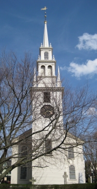
Trinity Church is home to the only remaining three-tiered wineglass pulpit remaining in its original position in the center of the aisle, in America. It indicates the importance of preaching during the colonial period, and the sermon at Sunday services is still given from it today. Most colonial churches had central pulpits, but many later moved them to the side.
On the south side of the main aisle, adjacent to the Clerk's Desk, is a box pew ornamented with engraved silver plaques commemorating visitors of special significance who were seated there. The earliest of these is George Washington; others include Queen Elizabeth II, Prince Andrew, and Archbishop Desmond Tutu and his wife Leah.
From 1985 to 1987, Trinity Church underwent a major restoration under the "Save Historic Trinity" program to stabilize the grand old building, which had developed a serious list from centuries of pressure from ocean winds. After careful research, the interior and exterior of the church were painted in their original colors. The tower clock was taken down, cleaned, and polished.
Today, visitors to Trinity are welcomed by members of the Guides Committee, fondly known as the "Sitting Saints," who delight in pointing out all the fine details of the church. Tours are given per the following schedule:
May 1st – June 15th: Monday – Friday 10:00 am – 1:00 pm
June 16th – July 7th: Monday – Friday 10:00 am – 4:00 pm
July 7th – Sept. 1st: 7 days a week 10:00 am – 4:00 pm
Sept 2nd – Oct 14th: Monday – Friday 10:00 am – 4:00 pm
Oct 15th – Oct 31st: Monday – Friday 10:00 am – 1:00 pm
Tours are also conducted immediately following the 10:00 a.m. Sunday service year round.
The church has been seen in several films, including Amistad and Evening. The Tiffany stained glass windows are valued at more than $3 million, and the organ was tested by Handel before being sent from England.
From the plaque to the right of the side door, "August 2a, 193d"

Stage 4 - St. Mary's Church
St. Mary's Church is the oldest Parish in the Diocese of Providence. It was founded in 1828, and construction of the current church was started in 1848. Father Woodley's pastorate, which lasted three years starting in 1828, included Providence, Pawtucket, Woonsocket, New Bedford, Fall River, Taunton, and the entire state of Connecticut.
St. Mary's is probably best known as the site of Sen. John F. Kennedy's and Jacqueline Lee Bouvier's wedding on September 12th, 1953.
From the sign in front of the church, "Consecrated on August 1e, 1884."
Stage 5 - Tennis Hall of Fame
The Tennis Hall of Fame at the Newport Casino, site of the first U.S. National Championships in 1881, was founded by tennis innovator James Van Alen in 1954 as "a shrine to the ideals of the game." The Tennis Hall of Fame was officially sanctioned by the United States Tennis Association in 1954 and was recognized by the International Tennis Federation in 1986. Over the last ten years, the Hall of Fame complex and Museum have been restored to their original splendor with the 1997 completion of a five year, $7.5 million renovation and endowment project.

Built in 1880 by the firm of McKim, Mead and White, the Museum's galleries chronicle the rich history of tennis through interactive exhibits, dynamic videos, and popular memorabilia from historic champions and the superstars of today. Dramatically set in the original club rooms of the Casino, visitors of all ages delight in Stanford White's architectural detail as well as the state-of-the-art gallery experience. In Enshrinee hall, plaques commemorate the great players, coaches, administrators and writers that have been inducted into the International Tennis Hall of Fame.
The 207 Hall of Famers (including the Class of 2008) represent 174 Players, 31 Contributors and 2 Court Tennis Players. Of the 58 women and 149 men, there are 18 left-handed players and 158 right-handed players. Of 18 countries represented, 119 are from the United States; 25 from Australia; 24 from Great Britain; 10 from France; five from Sweden, four each from Germany and the Czech Republic; three from Spain, two each from the Republic of South Africa, Argentina and Italy; and one each from Brazil, Ecuador, Ireland, Mexico, New Zealand, Peru and Romania.
From the plaque to the left of the entrance, "198c"
Final Stage - The Old Stone Mill
Cache is located in the same park as the tower. If you feel like trying to find it without visiting the other stages, knock yourself out!

The Newport Tower, a Newport iconic landmark, is located in Touro Park, at the top of Mill Street.
The tower has a height of 28 feet and an exterior width of 24 feet. At one time the sides were coated with a smooth coating of white plaster, the remains of which can still be seen clinging to the outer walls. It is supported by eight cylindrical columns that form stone arches, two of which are slightly broader than the other six. Above the arches and inside the tower is evidence of a floor that once supported an interior chamber. The walls are approximately 3 feet thick, and the diameter of the inner chamber is approximately 18 feet. The chamber is penetrated by four windows on what used to be the main floor, and three very small ones at the upper level. Almost (but not quite directly) opposite the west window is a fireplace backed with grey stone and flanked by nooks.
In a document of 1741 the tower is described as "the old stone mill." In 1760 the Tower was used as a haymow, while in 1767 it was described as having been used as a powder store "some time past". De Barres' plan of Newport, published in 1776, marks it as "Stone Wind Mill." During the American Revolution, the tower was used by the Americans as a lookout, and by the British to store munitions.
Most historians believe the tower is the mill that was constructed from the ground up in the middle or late 17th century by or for wealthy Rhode Island colonial governor Benedict Arnold, great-grandfather of the Revolutionary War general, Benedict Arnold. The tower is located at the upper end of the plot behind the now-demolished mansion built by Arnold, who moved into the area in 1661. In 1677 Arnold mentions "my stone build Wind Mill" in his will: the site for his then-new burying-ground, which survives to this day, is between this mill and his mansion. The phrase has therefore generally been accepted as referring to the Newport Tower, and is evidence the tower was once used as a windmill.
To this day, the tower remains at the center of controversy, with several theories as who built the tower, and why. Various efforts have been undertaken to try to ascertain more information about the tower. Several archaeological digs have been conducted.
The results of a dig in 1948, published in Godfrey's 1951 Ph.D. dissertation, concluded that all the artifacts discovered were from the 17th century.
In 1992, radiocarbon dating tests of the tower's mortar were undertaken by a team of researches from Denmark and Finland. The results support a construction date between 1635 and 1698.
In October and November 2006 and again in October and November 2007, the Chronognostic Research Foundation conducted an archaeological investigation of the anomalies discovered in Touro Park during geophysical studies of the past three years. Press reports following the first digging season clearly show that the earliest date of any one of the many artifacts excavated was 17th century.
At the end of the second digging season, in November 2007, Janet Barstad, president of the Chronognostic Foundation, surprised Newport city councilors by refocusing attention on the astronomical alignments as evidence for a medieval date of construction, on the basis that the archaeological excavations had not found anything conclusively related to the tower.
There have been numerous alternate hypothesis put forth over the years. I have listed them here, and it is left up to the reader to do more investigating on their own, and to come to their own conclusions.
- In 1837 the Danish archaeologist Carl Christian Rafn in his book Antiquitates Americanæ, proposed a Viking origin for the tower.
- In the 1990s, William Penhallow, an astronomy specialist at the University of Rhode Island (now professor emeritus) studied the windows in the tower and said that he found a number of astronomical alignments.
- The amateur historian Gavin Menzies argues in 1421: The Year China Discovered America that the tower was built by the Chinese navigator Zheng He in 1421.
- During the early 20th century, Edmund B. Delabarre's investigations of the Dighton Rock led him to propose that the tower was constructed as a signaling beacon by Portuguese navigator Miguel Corte-Real.
- Another hypothesis holds that it was constructed by the Scottish earl Henry Sinclair, who is claimed by some to have visited Nova Scotia and New England in the year 1398.
- Pre-Colonial maps by Gerardus Mercator and others are claimed to mark the tower's location.