In compass navigation, there are two kinds of “north,” “magnetic north” and “true north”. The difference between the two is measured as “magnetic declination,” and this multi-cache seeks to point out the difference in a practical way.
“True north” is the direction in which the geographic north pole is located along the earth’s rotational axis. “Magnetic north” is the direction a magnetic compass needle points along a local geomagnetic field, generally in the direction of the north magnetic pole, which is not the same as the geographic pole. Many factors affect the geomagnetic field in which a compass is used, including quantities of iron ores in the earth’s crust and fluctuations in field strength. It changes over both distance and time. The north magnetic pole of the earth (estimated in 2005 to be at 82.7°N 114.4°W) is moving. In fact, it’s moving so much so fast that some airport runways in Florida have had to shut down, change their navigational signage and reopen in the last couple of years.
A line known as the “agonic line” runs from western Lake Superior down into the Gulf of Mexico; it is the line through the U.S. indicating where true and magnetic north are functionally the same. This is where the line was in 2004:

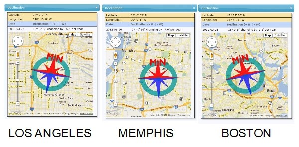
As of 3/26/2012 Minneapolis, St. Louis, Memphis and New Orleans all have a magnetic declination of zero degrees and some minutes and seconds, making most magnetic compasses in use there very accurate for finding true north. West of the agonic line a compass will give a reading east of true north (positive declination), and east of the agonic line will, conversely, give a compass reading west of true north (negative declination).
Here are screenshots from the magnetic declination tool at the NGDC (National Geophysical Data Center) website:
Here’s an example of how magnetic declination changes over time. On 3/26/2012 Omaha had an estimated magnetic declination of 3° 9' 34". But two years later, on 3/26/2014, the NGDC predicts that Omaha will have a magnetic declination of 2° 54' 11". And the NGDC reports that Omaha would have had a magnetic declination of 9° 36' 53" on March 26, 1912, 100 years ago and just a few weeks before the sinking of RMS Titanic. (One of the traditional mythic explanations for aircraft being lost in the Bermuda Triangle was its location on the agonic line, where true and magnetic north are the same. As you can see, the agonic line has shifted since then.)

Good compasses have an inner magnetic declination scale you can use to determine true north. Most GPS units calculate true north by default, and automatically compensate even when set to magnetic north. An etrex Legend works in “True,” “Magnetic,” “Grid” and “User” compass modes (the "user" mode is where you can set the declination to zero and use magnetic north).
The listed coordinates point to the first in a long line of objects that line up and point to true north pretty well. Call this number 1. To find stage 1, proceed from here true north until you get to number 79. Notate what you find there. Now imagine having used magnetic north instead, about 4 degrees away, to find stage 2. Combine what you find there with the previous information for the final location, stage 3. Have fun!
Clearly this area is a total muggle zone on game days. You may be better off working this one when there aren't a lot of practices or games happening.
Obviously, Omaha is close enough to the agonic line so that the magnetic declination is not greatly significant for most terrestrial navigation. But imagine navigating the US coastlines, particularly in search of treasure delineated on centuries-old maps, and the difference could be great indeed.