Ruined Castle EarthCache
-
Difficulty:
-

-
Terrain:
-

Size:  (other)
Please note Use of geocaching.com services is subject to the terms and conditions
in our disclaimer.
Ruined Castle is located at Falls Creek and is accessible via Pretty Valley Road in the off season. It is best attempted from November through to April - this is an alpine region and therefore the formation may be obscured by snow in the winter months. During the winter (peak) season there will be a charge to access the mountain, please check the Falls Creek website to confirm prices & accessibility (eg. whether chains are required to access the mountain, etc).
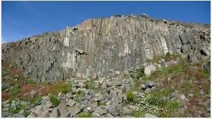
The rock feature that this earth cache brings you to is a wonderful example of a basalt "columnar structure". The volcanic eruption that was responsible for the creation of this outcrop occurred millions of years ago. Approximately one million years ago, an uplift of the area took place, forming the Bogong High Plains. Since then the terrain has continually changed through denudation and erosion and so exposing the rock outcrop as you see it today.
How columnar structures are created
During the cooling of a thick lava flow it contracts, the lava can shrink vertically without fracturing but will fracture with horizontal contraction. It is this multiple fracturing, or network fracturing, that results in the formation of columns. The resultant column is a polygon and can vary in shape from 3 to 12 sides.
For further in formation on basalt and columnar structures click here.
For other examples of columnar structures throughout the world click here.
Ruined Castle is one of the few remaining examples of columnar jointed basalt in the area. The starting co-ordinates will take you to a sign outlining the geographical history of the area.
To log this earthcache, please provide the following information via email (please DO NOT provide any answers in your log):
1. From the information available at the starting co-ordinates, what is the rock outcrop evidence of and how many years ago did this occur?
2. What is the predominant shape of the columns according to the sign?
3. Head along the formed walking track to the base of the formation to the following co-ordinates:
S 36 52.440
E 147 15.991
Advise your elevation at this point, we will accept variations within 5m
4. Looking at the rock formations, advise the rate of cooling of the basalt in this area and substantiate your reasoning for this answer (refer the Wikipedia link and scroll to the Columnar Basalt section)
5. We love photos, a picture of yourself or GPS in front of the feature would be appreciated but is purely optional (as per earthcache guidelines)

Additional Hints
(No hints available.)
Treasures
You'll collect a digital Treasure from one of these collections when you find and log this geocache:

Loading Treasures