The Cache:-

The first noted reference to Pirton was in the Domesday Book (A.D. 1086) where it was called "Peritone". This derives from 'peri-', meaning a pear tree, and 'ton–', meaning homestead. Pirton's most notable medieval monument is the Motte and Bailey castle ("Toot Hill") and within its precincts lies the 11th century parish church of St Mary's.
Until the 19th century the economy of the village was based on agriculture, growing crops such as wheat, oats, peas and beans, and barley for the malting trade in Hitchin. However, as the Luton hat trade grew in the middle of the 19th century Pirton became a straw plaiting village. By the start of the 20th century this activity started to decline and today Pirton is a commuter village.
The Geosquare Series:-
The Ordnance Survey (OS) National Grid provides a unique reference system, which can be seen on all Ordnance Survey maps of Great Britain. Great Britain is covered by 100 kilometre grid squares, each grid square is identified by two letters. On Ordnance Survey maps these squares are further divided into smaller 1 km squares by grid lines representing 1 kilometre spacing, each numbered from 0 to 99 from the south-west corner, in an easterly (left to right) and northerly (upwards) direction.
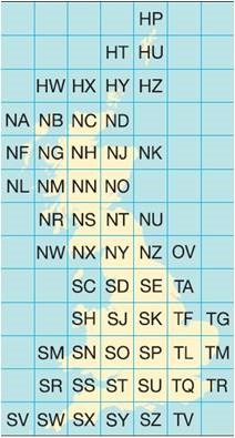
In the Geosquare series the cache is named after the square in which it is placed. Others are welcome to add to the series, using the logo, sidebar and description. Visit SuperTed's Profile page to see some other ideas on how he sees this series expanding.