There are 2 stages for this Earthcache both are along Highway 520. Stage 1 is located in James G. Bourbeau Memorial Park, and stage 2 is located at the Leroy Wright Recreation Area. Both stages are within .4 mile of each other. The parks are open 24 hours a day although this Earthcache is not recommended at night due to visibility and alligators.
NOTE: This is an earthcache, there is no physical container to find at the coordinates. To get your smiley for the cache you will need to e-mail your answers to the questions below to the cache owner.
The St. Johns River is the longest river in Florida at 310 miles long. It also has an interesting direction of flow which we hope you discover by doing this Earthcache. The total drop of the river from its source to its mouth is less than 30 feet (approx 1 inch per mile), which makes it one of the laziest rivers in the world!
What is a Meandering River?
Rivers that flow over gently sloping ground and begin to curve back and forth are called meandering rivers.
How is a Meandering River Formed?
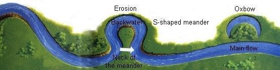
A meandering river erodes sediment from the outer curve of one river channel and then deposits the sediment to the inner curve of the river channel a bit downstream. Due to erosion of the outer curve the bank becomes deeper which causes the water to flow faster, and more sediment to be pushed to the inner curve. As time goes on this process makes the inner bank become shallower and point bars form.

What is an Oxbow Lake?
As the meanders grow bigger and bigger over time they begin to travel back and forth making loopy “S” shapes in the earth. Over time the necks of the “S” shaped meanders will get closer and closer together, and eventually join together. Once joined, the flow of water slows down and sediment begins to build up. After the sediment has built up enough the meander is cut off from the main flow of the river. The water left in the loop is called an oxbow lake. The process of forming an oxbow lake can occur anywhere from a few years to many decades. In areas with heavy rains and flooding, oxbows will form quicker.
How is the Amount of River Water Measured?
River water is measured by the rate of water flow. The rate of water flow in a river is the amount of water which passes through a section of a river channel per units in time. River flow is commonly measured in feet per second. The measurement is calculated by using the depth and width of a cross section of the river then calculated in square feet (Depth X Width = Area).
After the area is figured the next step is to measure the speed of flow (velocity) in the same section. This can be done by watching something float down the river and timing how long it takes to get from one point to another. Once this data is collected the total rate of water flow can be calculated as follows: (Area X Velocity = Discharge or water flow).

Note: For the purpose of this Earthcache due to alligators we will only be measuring velocity of the river.
Now it’s time for the application part of the cache. When answering the questions do your best. It is more important that you learn a new concept about our earth and can apply your knowledge, rather than have a precise answer.
Questions to answer: Stage 1: Standing near the icon coordinates (N28 22.039, W 80 52.319) at James G. Bourbeau Memorial Park: Mark 2 locations (using rocks or sticks) 10 feet apart from each that run parallel to the river bank. Look in the river for a piece of grass, leaf, or small stick floating along parallel to the shore. DO NOT throw trash into the river, if you cannot see something floating in the water use a small blade of grass or leaf.
1. How many seconds does it take for the floating object to travel 10 feet? How does your data compare to the average velocity of the St. Johns River flow of 10 feet per 20 seconds?
2. Notice which direction the objects float in the river. From this observation, what direction is the St. Johns River flowing? (This is a very neat fact as not many rivers in the United States do this).
For stage 2 you can walk if you don’t mind walking through some weeds or drive. If you do decide to walk there is a sidewalk part of the way along the waters edge underneath the highway. Stage 2: Walk along the boardwalk and stand at the coordinates (N 28 22.343, W 80 52.316) at Leroy Wright Recreation Area to answer the following questions:
3. Describe the color and clarity of the water in the river. What is the width of the river in feet?
4. Now look west and notice the meandering curve of the river. Which bank of the river is being eroded? What do you think about the chances of an oxbow forming here?
5. Why do you think the St. Johns River has so many meanders?
Thank you for visiting this earthcache. Please send your answers to the above questions to the cache owner. In your "found it" log feel free to write about your experience, but don't include the earthcache answers. Thanks and we hope you enjoy the beautiful St Johns River!
CONGRATULATIONS TO FLAXJER FTF!!!

Sources:
http://www.onegeology.org/extra/kids/earthprocesses/meanderingRivers.html
http://www.limpoporak.com/en/river/hydrology/principles+of+hydrology/surface+water/stream+order.aspx?print=1
http://en.wikipedia.org/wiki/River