 Located at Field's Point Landing and placed with permission. Fields Point was developed jointly by the U.S. Forest Service and the National Park Service to provide orientation and secure parking for visitors to Lake Chelan. Information, snacks, restrooms, picnic facilities, souvenirs, and a pay phone are available at the landing.
There may be seasonal periods that the parking lot will be closed. In those instances permission has been granted for geocachers to walk around the fence to gain access to the cache.

Lake Facts:
The name "Chelan" is derived from a modification of Tsill-anne, the Indian name for the lake, meaning "deep water." The lake is 1486 feet deep, making it the third deepest lake in the country and the 25th deepest in the world. (Only two lakes in the United States, Crater in Oregon and Tahoe in the high cradle of the Sierra Nevada are deeper.) A pebble dropped from one of the glacial summits would fall more than 7,000 feet, settling at a lake floor some 400 feet below sea level! In volume it would cover the state of Washington to a depth of almost 4 and 1/2 inches! While the average width of the lake is one mile , it is 55 miles long. Chelan is a cleft in the mountains, a bigger dent in the earth than the Grand Canyon.
 Origin of The Lake:
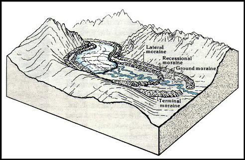
Lake Chelan is the product of a clash between two great masses of ice during the last ice sheet that covered British Columbia, Canada. The Cordilleran Ice sheet flowed down the Columbia River basin, through what is now the Chelan river basin, and into the east portion of what today is Lake Chelan. In the city of Chelan is found the terminal moraine of that ice sheet. A terminal moraine is also called an end moraine. It is a moraine that forms at the end of the glacier called the snout. Terminal moraines mark the maximum advance of a glacier.
At the same time, an alpine glacier formed on the eastern slopes of the Cascade Mountains and flowed into the area that is Lake Chelan from the west. The Glaciers collided, pushing against each other and increasing the downward digging and scouring action that formed the lake.
You may wonder what the difference is between an ice sheet, or continental glacier, and an Alpine Glacier. Glaciers are categorized in many ways by their morphology, thermal characteristics and their behavior. Alpine glaciers form on the crests and slopes of mountains and are also known as "mountain glaciers", "niche glaciers", or "cirque glaciers". An alpine glacier that fills a valley is sometimes called a valley glacier. Ice sheets, on the other hand are the the largest glacial bodies. Ice sheets or continental glaciers, cover more than 20,000 miles, are very deep, and can obscure the underlying topography.
Today, remnants of the Alpine glacier still cling to the mountain peaks on the west end of Lake Chelan above the small community of Stehekin. The Cordilleran Ice Sheet retreated far north into British Columbia where remnants of it still exist. Water melting from these glaciers and from winter snow around the lake still feeds Lake Chelan and the Chelan River, continuing the process and sedimentation that has been going on for a very long time.
Lake Levels
Lake Chelan has had many different water levels since the time of the glaciers. Evidence of these levels has been found in several locations. One of the greatest impacts on water levels has been the construction of the Lake Chelan Dam completed in 1927. Dam development occurred for navigation, power generation, water supply and to prevent a recurrence of flooding. Many factors now affect lake level including precipitation, temperature, snowpack conditions, and the amount and timing of spring runoff, as well as compliance with the dam's hydro project’s federal operating license and environmental objectives.

To qualify as a "find", email, (do not post online), the answers to the following questions. Please e-mail us at the same time you log your find. Failure to do that in a timely manner will result in a log deletion.
According to the sign located at the coordinates: (Please do not take a picture of it.)
1) What impact does the cold, clean water have on the lake?
2) What percentage of the lake's total volume is below sea level?
3) What is the region's favorite natural fish that is currently in drastic decline?
4) Since the lake level changes constantly throughout the year, estimate how much of the dock's support pole is visible above the water level. (See picture below).
If possible please post a picture of you or your GPSr with some of the views found at Lake Chelan.
I hope you have learned a thing or two about Lake Chelan. Thanks for visiting!

 |
Warning: Earthcaches come with a unique set of rules and activities that must be met
before successfully logging. Failure to comply will result in a log deletion.
|
|