[Cesky]
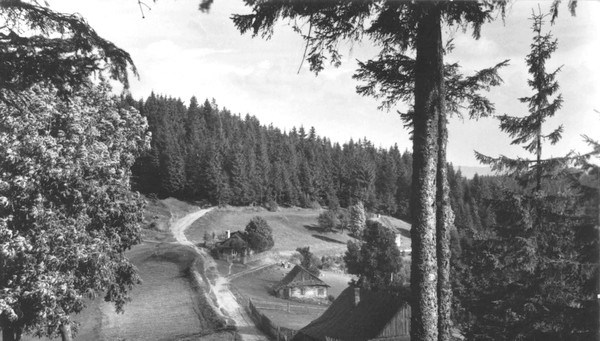
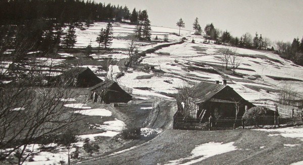
Cesta za keší Vás zavede do jižní části Beskyd, do sedla ležícího asi 500 m za vrcholem Beskyd (900 mnm) východním směrem k turistické chatě Kmínek. Sedlo leží v nadmořské výšce 850 mnm a je místem, kde se historicky rozkládala osada Smutníky. Tato osada obsahovala několik chalup, z nichž dnes stojí již jen dvě. Pohled na osadu ukazují historické fotografie.
Podle vyprávění dnes už bohužel zemřelých starousedlíků vedla do sedla z obce Bílá údolím Smradlavé stará obchodní cesta. která se zde větvila. Jedna část pokračovala na Slovensko směrem na Makov, druhá úbočím kopce vlevo směrem k chatě Kmínek. Trasou z obce Bílá do sedla dnes vede kolem Maxovy nádrže zelená turistická značka. Trasou na Slovensko přes osadu Hlboké směrem na obec Makov dnes vede ze sedla modrá turistická značka. Ze staré cesty směrem na Kmínek úbočím jsou již jen zbytky, dnešní červená turistická značka z Bumbálky přes vrchol Beskyd a dále na Kmínek vede po hřebeni.
Ze sedla je pěkný výhled jižním směrem na hřebeny Kysuc. Ve výhledu severním směrem na hlavní hřeben Beskyd bohužel brání vzrostlé smrky. Doufám, že se budou líbit historické fotografie osady. Do tohoto sedla se také můžete dostat v rámci výpravy do Himalájí, nejlépe při sestupu. Keš je umístěná přímo v sedle hned u cesty. Za pěkného počasí tu občas bývají turisti, tak prosím opatrně. Mírné násilí zleva povoleno, žádné speciální nástroje nejsou třeba.
[English]
The way for the cache will take you to the southern part of Beskydy to the saddle lying about 500 m behind the peak Beskydy (900 m) east to the tourist cottage Kmínek. The saddle lies at an altitude of 850 meters and is a place where historically was Smutníky settlement. This settlement contained a few cottages, which now stands only two. There are two historical photografies of the settlement.
According to legend old trade route led to the saddle from the Bila village. which are branched there. One part went to Slovakia towards Makov, the second on the left flank of the hill towards the cottage Kmínek. Route from the Bila village now leads to the saddle around Max's lake green trail. Route to Slovakia through the settlement towards the Makov village today goes from blue tourist sign.
There is a nice view to the south of the ridges Kysuce from the saddle. The outlook on the main north ridge Beskydy unfortunately prevents mature trees. I hope you will enjoy the historical photographs of the settlement.The cache is located right in the seat next to the road. There are tourists in fine weather sometimes, so please be carefull.