Skip to content

Perth's Watershed Divide Traditional Cache

This cache has been archived.

K'J': Container has been picked up. Thanks to everyone who dropped by the watershed divide!

More
Hidden : 7/3/2012
Difficulty:
1 out of 5
Terrain:
1.5 out of 5

Size: Size:   small (small)

Join now to view geocache location details. It's free!

Watch

How Geocaching Works

Please note Use of geocaching.com services is subject to the terms and conditions in our disclaimer.

Geocache Description:

Cache is an easy park and grab meant to bring you to an interesting educational spot. You're looking for a small container with room for tradeables and trackables. The grab is meant to be quick so you can spend time looking at the sign.


At the posted location you will find a large 15 foot sign indicating that you are located on a watershed divide.

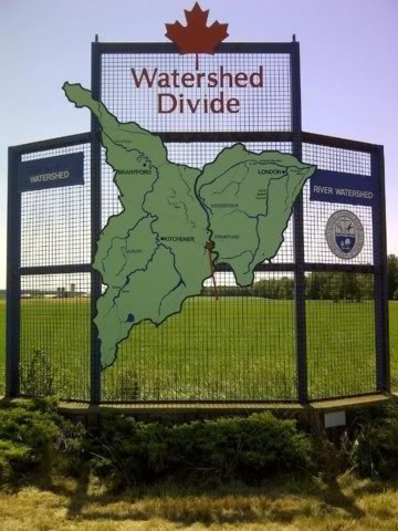
From this point, water falling to the east of this sign will flow 120 kms into Lake Erie via the Grand River while water falling to the West will flow 180 kms into Lake St Clair via the Thames River.

*********EDUCATION ALERT***********

A watershed starts at the highest points on the landscape, like mountain peaks, ridgelines, and hilltops that divide one valley or drainage from another. In every watershed, small streams flow into larger streams, which flow into rivers, lakes, and bays. The imaginary line that connects those high points is called the watershed divide. The watershed is normally named after the largest river or body of water at the lowest point in the landscape. To your left is the Grand River watershed and to your right is the Upper Thames watershed.
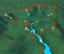
View of a watershed

Hope you enjoyed the spot!

Additional Hints (Decrypt)

Unatvat oruvaq. Ba gur Tenaq Evire fvqr.

Decryption Key

A|B|C|D|E|F|G|H|I|J|K|L|M
-------------------------
N|O|P|Q|R|S|T|U|V|W|X|Y|Z

(letter above equals below, and vice versa)