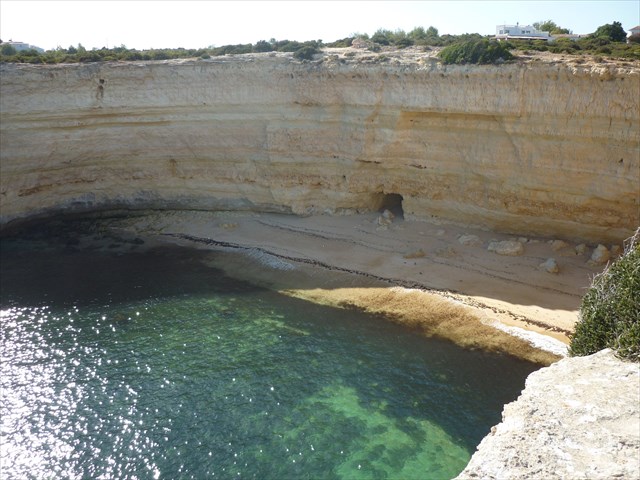
'Algares' (natural pits) are peculiar forms of relief, shaped amongst the limestone rocks that make up the coastline.
These formations, associated with naturally eroded limestone geomorphology, include a series of cavities with a variety of shapes and sizes. They arose and evolved as a result of erosion over million years.
Extensive fracturing of limestone structures encountered in this area facilitates the infiltration of rain water which, due to its high carbon dioxide content becomes acidified and dissolves the limestone. This continual process progressively increases the cracks in both width and depth, and gradually form natural pits, known in Portugese as 'algares'.
These formations establish connections between surface and the network of underground galleries and grottoes. They are naturally extremely fragile and often reveal areas with kinds of natural consoles, as well as unstable ridges, disintegrating walls, etc.
The pits at this site have occured due to the collapse of roofs of underground galleries.
Naturally eroded cavities are sometimes filled with reddish coloured, sandy-clayey deposits which offer little resistance against sea and land surface erosion. The fast erosion of these deposits in amongst the limestone structure means they are swept away from the coastline, leaving rocky outline with its intricately sculpted shapes, and many conspicuous rocky edges and islets.
In the Lagoa municipal area, the limestone rocks that from these pits and caverns are the basic lithological foundation of the cliffs, and from an extremely attractive stretch of coast.
As rochas calcárias que constituem o litoral do concelho de Lagoa são extremamente fracturadas. Tal facto permite uma rápida infiltração da água - fenómeno associado a uma considerável secura superficial e a uma intensa circulação subterrânea. A característica vegetação mediterrânica observável na região está bastante relacionada com este facto.
A água da chuva, carregada de dióxido de carbono, e por isso bastante acidificada, provoca a dissolução dos calcários, enquanto a rede de fracturas permite o seu transporte, por vezes a grandes distâncias.
Durante este processo a rocha vai sendo desgastada e as fendas vão sendo progressivamente alargadas formando, por vezes, poços naturais, denominados por algares. Estes estabelecem comunicações entre a superfície e a rede de galerias e grutas subterrâneas dado origem a uma paisagem típica denominada por paisagem cársica.
Muitas desta estruturas correspondem ao colapso dos tectos das galerias e apresentam frequentemente sectores em consola, arestas pouco estáveis e paredes em desagregação.
As cavidades cársicas podem, por vezes estar preenchidas por depósitos de areias argilosas, de cores avermelhadas, ponco resistentes à erosão marinha, vento, chuva e escorrência superficial. A erosão rápida deste preenchimento motiva o seu desaparecimento da faixa costeira, dando lugar a um contorno litoral rendilhado, com numerosos leixõs destacados.
 To log this cache mail the answer of the following questions to me.
You don't have to wait for my answer to log. I will contact you if your answer is wrong.
Questions to answer:
From what kind are the erosions that happened over million years? (Because the info-board is no longer readable, please answer by consideration or internet research.)
What is the diameter and the depth of the Algar? (Your GPSr can help you!)
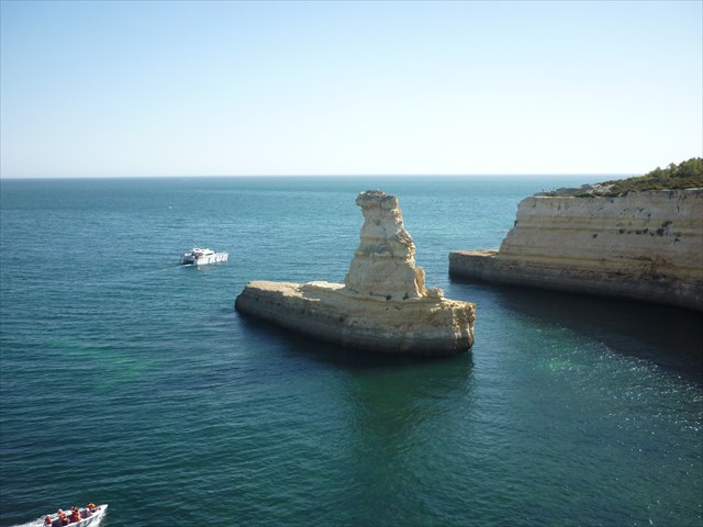
I would be pleased if you would upload a picture of you or of your GPSr with 'Submarine Rock' (picture above) in backround.
Para registrar este e-mail de cache a resposta das seguintes perguntas para mim.
Você não tem que esperar pela minha resposta para efetuar login. Entrarei em contato com você, se sua resposta está errada.
Perguntas a responder:
De que tipo são as erosões que aconteceram ao longo de milhões de anos? (Porque a placa de informações não é mais legível, responda por consideração ou pesquisa na internet).
Qual é o diâmetro e a profundidade do Algar? (O GPSr pode ajudá-lo!)
Eu ficaria contente se você carregar uma foto sua ou do seu GPSr com 'Submarine Rock"(foto acima) em backround.