Be smart, be an EarthCacher - geology rulez! ;)
Credits: Państwowy Instytut Geologiczny / Warszawa
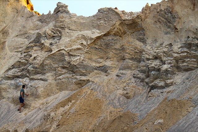
Just a part of Posejanka`s big "postglacial" wall... / Photo by Hanbei

Pojezierze Suwalsko-Augustowskie, zarówno pod względem ukształtowania terenu jak i bogactw naturalnych, jest regionem szczególnie bogatym w pozostałości po plejstocenie. Czwartorzęd - w skład którego wchodzą plejstocen i trwający do dziś holocen - jest okresem geologicznie na tyle krótkotrwałym (2,6 mln lat), że pozostałe po nim osady nie uległy utwardzeniu, skonsolidowaniu ani procesom metamorficznym (przemiany pod wpływem wysokich temperatur i ciśnienia). Osady te pozostały więc sypkie i niezwięzłe.
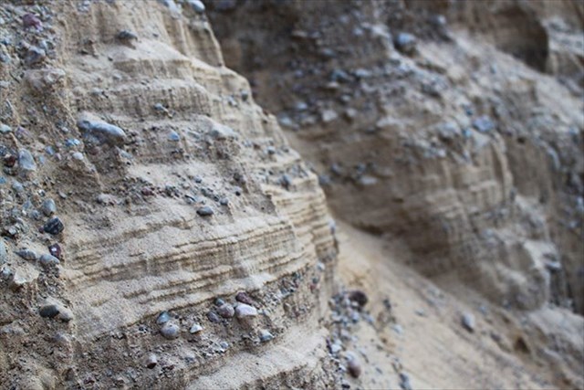 Outwash plain` sedimentations in Posejanka / Photo by Hanbei
Najbardziej charakterystycznymi pozostałościami po plejstocenie są tzw. osady akumulacji lodowcowej. Pojęcie to określa typowe utwory lodowcowe, powstałe pod lądolodem lub na jego krawędziach. Zalicza się do nich między innymi sandr, płaski i rozległy stożek napływowy, powstały podczas regresji lodowca lub lądolodu. Sandry są zbudowane ze żwirów i piasków, wypłukanych a następnie naniesionych i osadzonych przez wody topniejącego lub cofającego się lodowca na jego przedpolu.
Z geologicznego punktu widzenia sandr w Posejance jest interesujący przede wszystkim ze względu na doskonałe odsłonięcie: "wydobywany" jest tu żwir. Osiadłe na Suwalszczyźnie polodowcowe żwiry i piaski są największym bogactwem tego regionu Polski. Ich złoża ocenia się na ponad pół miliarda ton.
Posejański sandr znakomicie ilustruje możliwości akumulacji lodowcowej. Widać tu bardzo wyraźnie równolegle naniesione warstwy; na przemian piasku, żwiru oraz iłu piaszczystego. Miejscami widoczna jest glina ablacyjna jak i mniejsze lub większe otoczaki.
Posejański Eartchcache posiada dwa bonusy:
- paleontologiczny: jeśli trochę poszukacie u podnóża ściany, napewno znajdziecie skamieniałości
- ornitologiczny: bardzo liczne gniazda jaskółki brzegówki (Riparia riparia) tuż pod "okapem" skarpy
UWAGA: Samochód musi(!) zostać na poboczu drogi Sejny-Giby. Proszę zachować ostrożność: jeśli na terenie żwirowni ładowany jest żwir, wstęp na jej teren jest zabroniony. Prace takie są bardzo nieregularne, widać wtedy pod skarpą samochód ciężarowy z mini-koparką na pokładzie. Jeśli żwirownia jest pusta, można wejść na jej teren, jednak na własną odpowiedzialność(!). Poruszanie się jest dozwolone tylko po drodze prowadzącej wzdłuż ściany sandru.
Odpowiedzi proszę wysyłać za pomocą mojego profilu. Nie trzeba czekać na odpowiedź, można od razu logować. Jeśli odpowiedź będzie niepoprawna, zgłoszę się sam. Pamiętajcie proszę, że logi bez podesłanych odpowiedzi będą kasowane.
ZADANIA:
- Oszacuj wysokość odsłoniętej ściany sandru. Nie wchodź na jej szczyt, nie wspinaj się również skarpą na górę. Grozi to osunięciem się ściany i najgorszymi z możliwych konsekwencji dla ciebie!
- U podnóża skarpy widać struktury spływowe, tak piasku jak i żwiru. Są one oczywiście spowodowane ingerencją człowieka: wybieraniem kruszca mineralnego. Oszacuj średnią ziarnistość znajdującego się tu żwiru
- Czy glina ablacyjna jest tu często widoczna? Do jakiej głębokości - licząc od szczytu skarpy i widocznej tuż pod nią warstwy gleby - można ją zobaczyć?
- Jakiego koloru są tutejsze iły piaskowe?
- Po lewej stronie odsłonięcia osady sandru przebiegają równolegle do powierzchni, po prawej wyraźnie skosem w dół. Opisz powód tego ukształtowania?
- Zadanie opcjonalne: zdjęcie twoje lub twojego gpsa na tle wybranego fragmentu sandru

Suwalki-Augustów-Seenplatte ist sowohl landschaftlich wie auch, wenn es um Erzlagerstätten geht, sehr reich an Hinterlassenschaften des Pleistozän. Quartär - zu dem Pleistozän und der bis heute andauernde Holozän zählen - dauerte geologisch zu "kurz" (2,6 Mio. Jahre), so dass die von ihm hinterlassenen Ablagerungen und Schichten keine Zeit hatten richtig zu versteinern. Desweiteren wurden sie keinen metamorphen Umwandlungen unterzogen (Gestein, das bei großem Druck und hohen Temperaturen innerhalb der Erdkruste entsteht). Somit blieben die Ablagerungen lose.
Pleistozän-Spuren auf Suwalszczyzna findet man vor allem in Form glazialmorphologischer Akkumulationen. Unter anderem zählt dazu ein
Sander. Hierbei handelt es sich um einen breiten, schwach geneigten Schwemmkegel. Solche Kegel wurden im Vorfeld des skandinavischen Inlandeises während seiner Regression gebildet. Sander entsteht, wenn Gletscherschmelzbäche die Endmoräne durchschneiden und sich in der Ebene dahinter als verflochtener Fluss verbreitern. Dadurch verliert der Schmelzbach stark an Geschwindigkeit und lagert das mitgeführte Material als glazifluviales Sediment ab.
Im Fall dieses Eartcaches kann man sagen, dass er relativ nah an der früheren Endmoräne liegt. Denn: gröberes Material lagert sich nahe an dieser ab, wohingegen feinerer Kies und Sand noch weit flussabwärts getragen werden.
Geologisch gesehen ist der Sander in Posejanka grade deswegen interessant, weil er vollständig freigelegt wurde: hier wird Kies abgebaut. Dieses mineralische Erz wird in Suwalszczyzna auf eine halbe Milliarde Tonnen geschätzt.
In der Akkumulation sind mehrere Ablagerungen zu sehen, größtenteils horizontal aufgeschichtet: Kies, Sand, auch glazialler Lehm und mehrere Schluffschichten.
Dieser
Eartcache hat zwei Bonus-Punkte:
- einen paläontologischen: sucht ihr ein wenig am Fusse der Wand, findet ihr sicherlich paar Versteinerungen
- einen ornitologischen: unterhalb der Sanderkante sind mehrere Nestlöcher der Uferschwalbe (Riparia riparia) zu bewundern
WICHTIG: Der Wagen muss auf dem Straßenrand der Hauptstraße Sejny-Giby abgestellt werden, ansonsten blockiert ihr die Durchfahrt. Wird grade der Kies abgebaut, darf das Gelände nicht betretten werden! Dies passiert recht selten und in unregelmäßigen Abständen. Nachmittags ist das Gelände immer frei.
Betreten des Geländes erfolgt auf eigene Gefahr. Man darf sich nur auf dem vorhandenen Weg bewegen. Die Abbruchkante darf auf keinen Fall über die Sander-Wand bestiegen/erklättert werden: Erdrutsch-Gefahr!
Bitte sendet eure Antworten über mein Profil. Ihr könnt direkt loggen, ohne auf meine Rückmeldung zu warten. Falls eure Antworten falsch sind, werde ich mich melden. Denkt daran: Log-Einträge ohne die entsprechende Antwort-E-Mail werden gelöscht.
AUFGABEN:
- Schätze die Gesamthöhe der Sander-Wand ab. Kein genauer Wert wird hinterfragt: du musst nicht die Abbruchkante erreichen. Sie darf nicht über die Wand erklättert werden, da dies mit einem Erdrutsch und fatalen Konsequenzen drohe!
- Am Wandfuss findet man Kiesablagerungen vor: schätze die durchnittliche Kieskörnigkeit ab (mm-cm)
- Wie tief, gemäßen von der Abbruchkante, reichen die Lehmablagerungen (m)?
- Wie sind die hiesigen Schluffschichten gefärbt?
- Im linken Wandteil sind die Ablagerungen horizontal, im rechten wiederum sichtbar schräg. Warum?
- Optionale Aufgabe: ein Bild von dir oder deinem GPS vor dem Hintergrund der Wand oder ihres Abschnittes.

In terms of natural topography and resources, the Suwałki-Augustów Lake District is particularly rich in Pleistocene remnants. The Quaternary Period, which consists of two geologic epochs, the Pleistocene and Holocene (the latter continues to the present), lasted for a relatively short time in geological terms (2.6 million years), therefore its remaining deposits did not undergo any process of lithification, consolidation or metamorphism (that means changes produced with increasing pressure and temperature conditions). This is why the deposits remain loose. Among the most characteristic remnants of Pleistocene are glacial accumulation deposits. This term refers to typical landforms created either under the continental glacier or on its edges. They include, among others, the
outwash-plain-wall.
In Posejanka you will find tracks from the past: glacial prints of pleistocene. On the coordinates you stand in front of "unveiling" outwash-plain-wall. Unveiling because of gravel quarrying. If the job is going on, keep off the area. The works are made rare and uneven: in the afternoon the area is mostly free. Note that you go here by your own risk. Don`t climb the wall, it is dangerous: landslide!
This Earthcache has two bonus-points:
- a paleontologic one: keep your eyes open and you will surely find on the wall`s base a fossil
- an ornithologic one: on the breakeline you will see many nest-holes of the Sand Martins (Riparia riparia)
IMPORTANT: Your car
must stay on the roadside (Sejny-Giby) or you will bar the way to the gravel pit! Don`t climb the wall (landslide), walk only the sandy road!
Please answer the following questions and send the answers via my Geocaching profile. There is no need to wait for my reply, feel free to log immediately after. If the answers are incorrect, I will let you know. Please bear in mind that logs posted by persons who hadn't sent in the answers will be deleted. TASKS:
- Estimate, how high is the outwash-plain-wall (no precise measurement)?
- On the wall`s base you will find some natural gravel deposits. Estimate the average grain size (mm-cm)
- How deep you still can see the postglacial loam (measured from the breakeline) (m)?
- What are the colors of silt`s sedimentations?
- In the left part of the wall all sedimentations are horizontal. On the right side they trend inclined. Why?
- Optional work: make a photo with your gps in front of the most interesting part of the wall. Of course, by your "most interesting" choice ;)
Earthcaches are cool, just think and cache them ;))
