L'inversion de relief est un phénomène dû à l'érosion qui fait qu'une coulée de lave qui primitivement se trouvait au fond d'une vallée se retrouve, des millions d'années plus tard, comme un plateau dominant le paysage.
Dans la région d'Olloix les inversions de relief sont très nombreuses: la plus spectaculaire et la plus connue est la Montagne de la Serre, vaste plateau en pente douce qui s'étend du Lac de La Cassière jusqu'au village du Crest; la plus significative historiquement est le plateau de Gergovie.
Inversion of relief, inverted relief, inverted topography, or topographic inversion refers to landscape features that have reversed their elevation relative to other features. It most often occurs when low areas of a landscape become filled with lava or sediment that hardens into material that is more resistant to erosion than the material that surrounds it. Differential erosion then removes the less resistant surrounding material, leaving behind the younger resistant material which may then appear as a ridge where previously there was a valley. Terms such as "inverted valley" or "inverted channel" are used to describe such features.
In the region of Olloix inversions of relief are numerous: the most spectacular and best known is the Montagne de la Serre, a wide gently sloping plateau which extends from the Lac de La Cassière to the village of Le Crest; the most historically significant is the plateau of Gergovie.
Comment des coulées de laves qui étaient moulées au fond de vallées se retrouvent aujourd'hui comme des plateaux en relief :
How lava flows that were molded in the depths of valleys are found nowadays as relief plateaux:
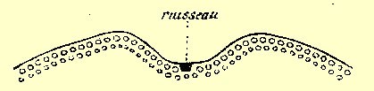
Etape 1 / Stage 1
Un ruisseau creuse une vallée dans des sédiments.
A stream forms a valley in sediments.
|
|
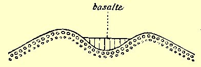
Etape 2 / Stage 2
Une coulée de basalte se moule dans la vallée et la comble en partie.
A flow of basalt molds itself into the valley and fills it up partly.
|
|
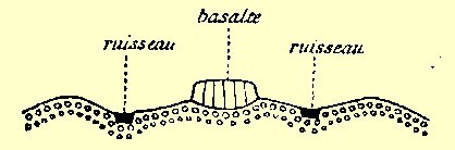
Etape 3 / Stage 3
La coulée de basalte protège les sédiments sur lesquels elle repose. Le ruisseau ne pouvant pas démolir la coulée donne naissance à deux nouveaux ruisseaux qui créent ainsi deux nouvelles vallées dominées par un plateau basaltique.
The basalt flow protects sediments on which it rests. The stream can not demolish the basalt and now forms two new streams creating two new valleys dominated by the basalt plateau. |
|
Pour loguer cette Earthcache:
1. Rendez-vous aux coordonnées de la cache et admirez le paysage tout autour de vous, en particulier la Montagne de la Serre qui va jusqu’ à Nadaillat.
2. Réalisez que le plateau sur lequel vous vous trouvez, était autrefois dans une vallée.
3. Notez l’animal dessiné sur la table panoramique dans le pré au pied de la Montagne de la Serre.
4. Envoyez-nous un mail avec le nom de l’animal et une petite explication de la formation d’une inversion de relief.
5. Pas besoin d’attendre notre réaction pour loguer.
To log this Earthcache:
1. Go to the given coordinates and enjoy the view all around you, especially La Montagne de la Serre which goes up to Nadaillat
2. Realise that the plateau that you are now standing on, was a valley millions years ago.
3. Note which animal is painted on the panorama table in the field at the bottom of the Montagne de la Serre.
4. Mail us the name of the animal and a short explication of the formation of inversion of relief.
5. You don’t need to wait for our answer to log this cache.
