Deutsch
Hier am Darßer Ort befindet Ihr Euch in einem Anlangungsgebiet. Anlandung oder auch Aggradation bezeichnet im Gegensatz zur Verlandung eine Ablagerung von Bodenmaterial, das von außen antransportiert (z. B. Kies, Sand, Lehm), an Küsten abgelagert wird und dort zur Auffüllung des Gewässers und damit zur Landgewinnung führt.
Vor Ort könnt Ihr die verschiendenen Arten von Küstendünen - Weißdüne, Graudüne und Braundüne - sehen. Zudem seht Ihr hier eine weitere Besonderheit, die bei Anlandungsprozessen vorkommt: einen Strandsee.
ACHTUNG: Ihr befindet Euch hier im Naturschutzgebiet "Nationalpark Vorpommersche Boddenlandschaft"! Bitte bleibt also unbedingt auf den vorgegebenen Wegen. Es besteht kein Grund, diese zu verlassen.
Die Weißdüne
Zunächst bilden sich bei der Anlandung die sogenannten Weißdünen.
Die Weißdüne, auch Sekundärdüne oder Haldendüne, besteht aus reinem Quarzsand aus der Primärdüne. Hier sind erste Anzeichen der Bodenbildung erkennbar, es bleibt aber bei einem Rohboden (Lockersyrosem) mit geringem Nährstoffgehalt. Daher ist sie nur zu 10–30 % mit Pflanzenbewuchs bedeckt. Typische Pflanzen sind Strandhafer, Strandroggen, Filzige Pestwurz und Stranddistel.
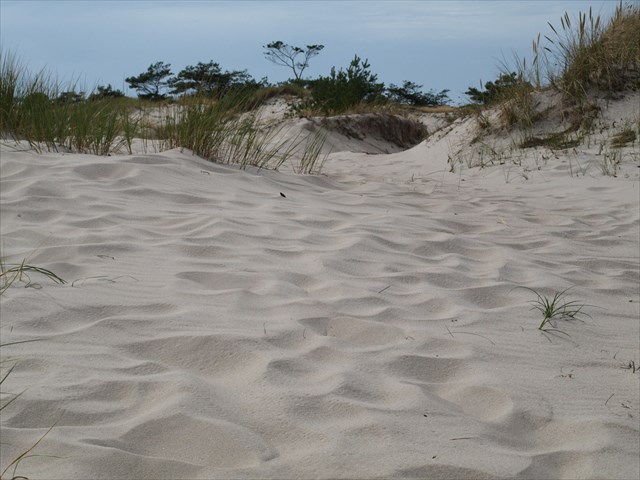 Weißdüne am Darßer Ort mit Graudünen im Hintergrund
Die Graudüne
Weißdüne am Darßer Ort mit Graudünen im Hintergrund
Die Graudüne
Aus der Weißdüne entwickelt sich die Graudüne. Die Graudüne wird zusammen mit der Braundüne auch als Tertiärdüne bezeichnet.
Auf der Graudüne, gekennzeichnet durch den grau scheinenden Boden wie auch viele weiß-grau behaarte Pflanzen, reichert sich immer mehr Humus an, der sich aus zersetzen Pflanzen bildet. Damit wird sie zum geeigneten Lebensraum für Zwergsträucher. Der pH-Wert einer Graudüne sinkt in der Zeit ihres Bestehens von etwa pH 6 bis 7 auf pH 4 bis 5.
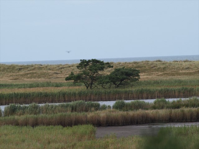
Die Braundüne
Nächste Entwicklungsstufe ist die Braudüne, die wie die Graudüne auch Tertiärdüne bezeichnet wird.
Hier wachsen sogar größere Sträucher und Trockenheit ertragende Bäume. Die Bodenfarbe hat sich zu einem Braunton verändert, eine Braundüne hat sich entwickelt.
 Braundüne mit Baumbestand am Darßer Ort
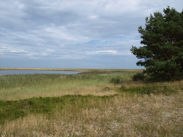
Der Strandsee
Braundüne mit Baumbestand am Darßer Ort
Der Strandsee
Strandseen sind ehemalige Meeresarme, die durch Anlandungsprozesse vom Meer abgeschnürt wurden. Der Libbertsee hier vor Ort ist ein Beispiel dafür. Der Salzgehalt des Wassers dieses Sees nimmt seit seiner endgültigen Abtrennung von der Ostsee ständig ab, so dass sich immer mehr Süßwasserpflanzen ansiedeln, wie zum Beispiel das Schilf.
 Libbertsee
Um diesen Earthcache zu loggen, müsst Ihr folgend Frage beantworten / folgende Aufgaben erfüllen (Achtung: die bisher vorhandene Infotafel wurde offenbar entfernt; daher ggf. Internetrecherche erforderlich):
1. Woher kommt die charakteristische Färbung der Graudüne?
Libbertsee
Um diesen Earthcache zu loggen, müsst Ihr folgend Frage beantworten / folgende Aufgaben erfüllen (Achtung: die bisher vorhandene Infotafel wurde offenbar entfernt; daher ggf. Internetrecherche erforderlich):
1. Woher kommt die charakteristische Färbung der Graudüne?
2. Was reichert sich in der Graudüne immer mehr an, so dass sich diese zur Braundüne entwickelt und Lebensgrundlage für weitere Pflanzen bildet?
3. Wann erfolgte die endgültige Abtrennung des Libbertsees von der Ostsee?
4. Warum haben im Libbertsee bislang noch keine Frösche und Kröten abgelaicht?
5. Macht ein Foto von Euch oder Eurem GPS am Hochsitz und stellt es mit Eurem Log ein.
Schickt mir VOR DEM LOGGEN eine E-Mail mit Euren Antworten, Eurem Cachernamen und Eurer E-Mailadresse durch mein Profil. Bitte die Antworten nicht in Eurem Log einstellen! Anschließend dürft Ihr den Cache loggen; Ihr müsst nicht die Logfreigabe abwarten. Wenn etwas mit Euren Antworten nicht stimmt, melde ich mich bei Euch.
English
Here at Darßer Ort you find yourself in an landing area respectively in an aggradation area. Landing or aggradation means deposition of soil material that is transported to the site from the outside (eg, gravel, sand, clay) at the coasts, where it leads to the filling of the water and thus to land reclamation.
In addition to the various types of coastal dunes - yellow dunes, grey dunes and brown dunes - you will find another feature of aggradation at this site: a beach lake (the Libbertsee).
the yellow dune
Yellow dunes are sand dunes that develop after the first set of embryo dunes appear. With an average depth of about 5m, with a soil to sand ratio that is small on the soil side (hence yellow dunes).
The percentage of exposed sand on these dunes is generally about 20%. At the site only about 10 - 30 % of the surface is covered with vegetation. The plants on these dunes can withstand the slightly alkaline sand an example of the plants would be marram grass spinifex.
The moisture content of these dunes is relatively low so the plants still have very strong root structure and are capable of getting every drop of water that comes their way.
the grey dune
Grey dunes are fixed, stable sand dunes generally located 50–100 m from the edge of the ocean. Grey dunes occur on the landward side of bare white dunes. Grasses and lichens such as the Cladonia species grow on the grey dunes.
the brown dune
The next stage of development is the brown dune that contains even more humus than the gray dune.
Even larger shrubs and drought-enduring trees grow on the brown dune The base color has changed to a brown color (hence brown dunes)
the beach lake
Beach lakes are former estuaries that have been cut off from the sea by aggradation processes. The local Libbertsee is an example. The salinity of the water of this lake is steadily decreasing since its final separation from the Baltic Sea, so that more and more freshwater plants colonize, such as the reed.
To log this earthcache you have to answer following questions:
1. Where does the grey colour of the grey dunes come from?
2. What accumulates in the grey dune more and more, so that it becomes a brown dune and livelihood for more plant forms?
3. When was the Libbertsees (local beach lake) finally separated from the Baltic Sea?
4. Frogs do not spawn in the Libbertsee yet. Tell me why?
5. Take a photo of yourself or your GPS at the deerstand and upload your picture with your log.
Send me an E-Mail with your answers, your caching name (eg erdnus) and your email address through my profil BEFORE YOU LOG. Afterwards you can log the cache as a find and upload your picture. Please do not reveal the answers in your log! You don't have to wait for my confirmation. I'll contact you if there is anything wrong with your answers.
In memoriam Mibine