Entstehung eines Salzsattels EarthCache
Entstehung eines Salzsattels
-
Difficulty:
-

-
Terrain:
-

Size:  (not chosen)
Please note Use of geocaching.com services is subject to the terms and conditions
in our disclaimer.
Entstehung eines Salzsattels – der Hildesheimer Wald

Der Hildesheimer Wald stellt eine geologische Besonderheit dar, da er weder glazialen, noch tektonischen Ursprungs ist, sondern durch Halokinese entstand.
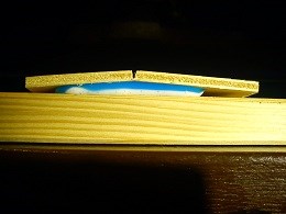
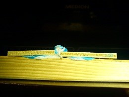
Dem zugrunde liegt ein putziges physikalisches Phänomen: Salzkristalle reagieren unter hohem Druck plastisch, d.h. wie Kaugummi nur sehr viel zäher. Nachdem sich im Perm (299-251 Mio a) das Zechsteinmeer gebildet hatte und mehrfach wieder verdunstet war, lagerten sich über den dabei kristallisierten Zechsteinsalzfolgen verschiedene Gesteinsschichten ab, u.A. Buntsandstein. Dieser und viele weitere Gesteine lasteten tonnenschwer auf der Salzschicht. Als Europa in der Kreidezeit (145-65 Mio a) tektonisch in Bewegung kam, bildete sich im Gebiet des Hildesheimer Waldes eine Bruchlinie und das plastische Salz brach die Deckschicht aus Buntsandstein auf und bahnte sich seinen Weg nach oben. Dabei drückte es das über dem Buntsandstein liegende Material ebenfalls nach oben und auf dem Ergebnis stehst du nun – auf dem Hildesheimer Wald, einem sogenannten Salzsattel.
An den Koordinaten findest du den durch eine Betonplatte abgedeckten Schacht des Bergwerks Mathildenhall – einen industriellen Zeugen für einen oberflächennahen Salzstock. Das Bergwerk war bis 1959 in Betrieb und wurde noch bis in die 90er Jahre als Reservebergwerk offen gehalten. Gefördert wurden verschiedene Kalisalze, u.A. Silvit (KCl) und Carnallit (KMgCl3 · 6H2O).
Modell mit erkennbarer Bruchlinie


Modell mit geborstener Bruchlinie und entstandenem Salzsattel
Logaufgaben:
1) Begib dich an die Koordinaten und finde heraus, wie tief unter dir der Salzstock liegt. Die Antwort findest du auf der Abdeckung des Schachtes. (Schwindelfrei bleiben!  ) Ein Foto von dir vor Ort erfreut, ist aber keine Logedingung.
2) Baue ein eignes Modell, das die Halokinese demonstriert, und mache davon ein Foto.
Bewährt haben sich 3 Bretter o.Ä. als Gestein und Kaugummi, Knete, Zahnpasta, Pudding o.Ä. als Salz. Lade das Foto im Log hoch.
Sende die Antwort auf Frage Nummer 1) an mich und du darfst sofort loggen. Bei Fehlern melde ich mich.
Viel Spaß wünscht
Miraculix84
Quellen und weiterführende Literatur:
Gerhard Meier-Hilbert: Geographische Strukturen - das natürliche Potential
Wikipedia: Kaliwerk Hildesia
Bildquellen: Eigenes Werk
Origin of an arch upfold – der Hildesheimer Wald

Hildesheimer Wald is from the geological point of view something very special, as its origin is neither glacial nor tectonic, but salt tectonic.
The reason is a physical phenomenon: Cristals of salt behave plastically, if they are under really high pressure – just like a chewing gum but much more sticky. 250 Mio years ago the biggest part of central Europe was covered by a very large semi-enclosed sea. As there was only very few connection to the oceans, there was hardly any exchange of water, and as the climate was very hot, the semi-enclosed sea behaved just like a huge salt pan. So the different salts, soluted in the sea, precipitated one by one. After that the salt was covered by different kinds of stones f. e. bunter. These were very heavy and caused a high pressure onto the salt. When there was a tectonic movement in Europe in Cretaceous period (145 – 65 Mio a ago), a fault was formed in Hildesheimer Wald and the plastical salt broke the cap rock and cleft its way up to the top. At that it pushed the overlaying material of bunter to the top as well and the result is to be seen right beside your feet – Hildesheimer Wald – an arch upfold.
Right at the coordinates you will find an ancient pit of the mine Mathildenhall covered by a concrete slab – an industrial witness for a salt dome near to the surface. The mine was in operation until 1959 and was kept in stand-by mode until to the nineties. Different potash salts were banked: e. g. Silvit (KCl) and Carnallit (KMgCl3 · 6H2O).
Model with recognizable break line


Model of broken break line and formed arch upfold
Conditions to log:
1) Go to the coordinates and find out, how deep the salt dome below you is. The answer can be found on the concrete slab. (Don't lose your balance!  ) A picture of the location to prove your presence would be a pleasure for me, but this is no condition for logging.
2) Build your own model to show what happened. Take a picture of your model and upload it with your log.
Have fun!
Miraculix84
Further literature:
Gerhard Meier-Hilbert: Geographische Strukturen - das natürliche Potential
Wikipedia: Kaliwerk Hildesia
Bildquellen: Eigenes Werk
Additional Hints
(No hints available.)