Karst Cave - Cueva Karstica
|
|
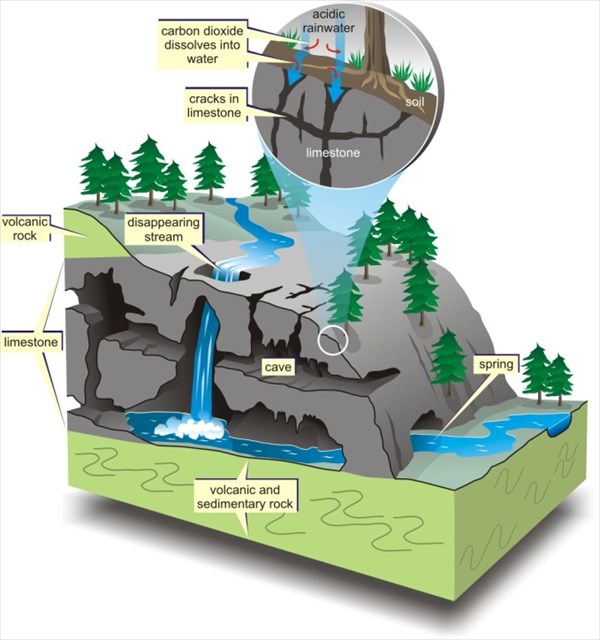
 Karst topography is a geological formation shaped by the dissolution of a layer or layers of soluble bedrock, usually carbonate rock such as limestone or dolomite, but has also been documented for weathering resistant rocks, such as quartzite, given the right conditions. Karst topography is a geological formation shaped by the dissolution of a layer or layers of soluble bedrock, usually carbonate rock such as limestone or dolomite, but has also been documented for weathering resistant rocks, such as quartzite, given the right conditions.
|
 Con el nombre de karst (de Karst nombre alemán de la región eslovena de Carso), carst o carso se conoce a una forma de relieve originada por meteorización química de determinadas rocas, como la caliza, dolomía, yeso, etc., compuestas por minerales solubles en agua. Con el nombre de karst (de Karst nombre alemán de la región eslovena de Carso), carst o carso se conoce a una forma de relieve originada por meteorización química de determinadas rocas, como la caliza, dolomía, yeso, etc., compuestas por minerales solubles en agua.
|
 |
|
Since dissolution is the most important process in the development of a karst, we can say that any rock can be part of a karst whenever it is soluble and has discontinuities through which water can penetrate. The materials that are more often karstified are the carbonates (limestone and dolomite), basically due to their solubility (in the presence of CO2) and because they are abundant in the earth's surface compared to other soluble rocks.
Origin and Classification:
A limestone is defined for its composition, its calcitic mineralogy. However, the source can be very diverse and it can be splited into two main groups:
- Limestone alien: those formed by grains or particles detached by erosion to other limestones. These particles are moved by a means of transport, such as underwater currents, and sedimented in a watershed.
- Limestone native: They are also composed of particles of different sizes, but these have not been plucked from a preexisting rock but have generated within the basin due to the action of living things.
|
Al ser la disolución el proceso más importante en el desarrollo de un karst, puede decirse que cualquier roca es karstificable mientras sea soluble y tenga discontinuidades por donde el agua pueda penetrar. Los materiales más frecuentemente karstificados son los carbonáticos (calizas y dolomías), fundamentalmente por su solubilidad (en presencia de CO2) y debido a que son muy abundantes en la superficie terrestre en relación a otras rocas solubles.
Origen y Clasificación:
Lo que define a una caliza es su composición, su mineralogía calcítica. No obstante, el origen puede ser muy diverso y se puede subdivir en dos grandes grupos:
- Calizas alóctonas: aquellas formadas por granos o partículas arrancadas por erosión a otras calizas. Estas partículas son movilizadas por un medio de transporte, por ejemplo las corrientes submarinas, y sedimentadas en una cuenca.
- Calizas autóctonas: Están también compuestas por partículas de diferentes tamaños pero éstas no han sido arrancadas de una roca preexistente sino que se han generado en el interior de la propia cuenca debido a la acción de los seres vivos.
|
Birth of the / Nacimiento del
Rio Mundo
|
|
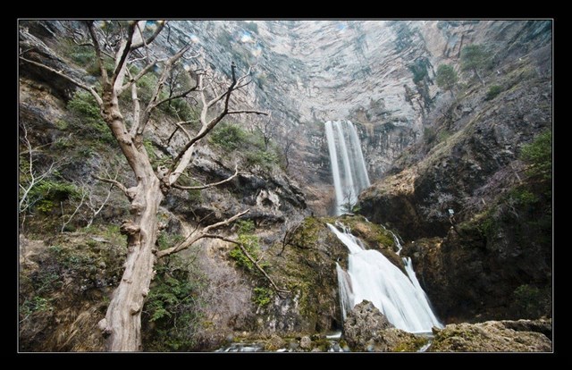
“El Mundo” is a Spanish river, the main affluent of the Segura river that borns in the mountains of the “Calar del Mundo”, in the region of the Sierra de Alcaraz (Albacete).
|
Mundo es un río español, principal afluente del río Segura que nace en la sierra castellana del Calar del Mundo, en la comarca de Sierra de Alcaraz (Albacete).
|
 |
|
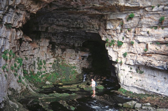
The Calar del Mundo is located in one of the tectonic scales of the Sierra de Alcaraz, with an area of approximately 200 km2. This rock package is formed exclusively of limestones and dolomites belonging to the Late Cretaceous. This package of carbonate rocks has just over 300 meters of thickness and has like a wall the Utrillas facies, which forms an impermeable base. The pit of the cave of the “Chorros” opens in its north wall, the source of Río Mundo.
The volume of water from the falls is highly variable and may be limited in time of drought. But seasonally happens a singular phenomenon because the source is connected to the karst aquifer, composed of numerous chasms and caves. Snow and ice can get to plug the exit of the Chorros cave, so water accumulates inside. There comes a time, when temperatures rise at the beginning of spring, the plug melts and happens the blowout.
|
El Calar del Mundo se encuentra en una de las escamas tectónicas de la Sierra de Alcaraz, con una superficie de aproximadamente 200 km2. Este paquete de roca está formado en exclusiva por calizas y dolomías pertenecientes al Cretácico superior. Este paquete de rocas carbonatadas posee algo más de 300 m de espesor y tiene como muro la facies Utrillas, que constituye una base impermeable. En su pared Norte se abre la boca de la cueva de los Chorros, nacimiento del Río Mundo.
El volumen de agua de las cataratas es muy variable y puede ser escaso en tiempo de sequía. Pero estacionalmente, ocurre un fenómeno singular, ya que el nacimiento está conectado al acuífero kárstico, conformado por numerosas simas y grutas. La nieve y el hielo pueden llegar a taponar la salida de la gruta de Los Chorros, por lo que se acumula el agua en su interior. Llega un momento, cuando las temperaturas suben, al comienzo de la primavera, que el tapón se deshace y se produce el reventón.
|
 |
|
The water goes out as a blasting, with a volume that can be up to one hundred times bigger than any other time. These sharp seasonal variations in water volume in upwelling are also called "Trop plein". The best time to visit is spring, at the dates when an explosion occurs spontaneously producing an extraordinary upwelling of water, this curious karst phenomenon is popularly known for locals as the "Reventón".
Reference material:
Inside the cave (Spanish TV program “Al filo de lo imposible”)
For logging this cache, please send correct answers to questions below to picaraxteam@gmail.com:
- At the coordinates N38º 27.159 W002º 26.234, there is a large rock with a two pipes fountain. What is the temperatura of the water?
- Notice that there is another rock to the left of the fountain that forms an angle. Stand on a sign that says "Recuerde prohibido el baño. Calderetas" you will have to estimate the angle.
- At the coordinates N38º 27.090 W002º 26.210, you will observe calcareous rocks detached from the mountain. Noting some of the broken rock, answer this question: What kind of Karst do you think that predominates in the headwaters of the river Mundo, limestone alien or limestone native?
- Once you arrive at the coordinates N38º 27.077 W002º 26.206, you will have to answer three more questions. First: You will see a geological formation process from the limestone. What do you think is precipitated, for the formation of rocks here?
- Second: all around you can see that on the rock, due to the prevailing moisture, a very common type of plants grow. What kind of plant do you think is it?
- Third: From this point you can see that the water comes from the jig through many sites, apart from the mouth of the cave. What color do you see that takes the limestone due to continuous moisture?
- Finally, in the coordinates N38º 27.149 W002º 26.307 you can see a process of weathering of the limestone creating a formation called scree. How big are most of the rocks that you can see?
- Optional: take a picture with the GPS in hand and the waterfall in the background.
|
El agua sale como un chorro a presión, con un caudal que puede ser hasta cien veces superior al de cualquier otro momento. Estas bruscas variaciones estacionales de volumen de agua se denominan también surgencias en "Trop plein". La mejor época para visitarlas es la primavera, en las fechas cuando se produce espontáneamente una explosión extraordinaria de surgencia de agua; fenómeno kárstico curioso y popularmente conocido en la zona como el "Reventón".
Material de consulta:
Dentro de la cueva (Al Filo de lo imposible)
Para loguear este cache, por favor envía las respuestas correctas de las siguientes preguntas a nuestro correo picaraxteam@gmail.com:
- En las coordenadas N38º 27.159 W002º 26.234 se encuentra una gran peña con una fuente de dos caños. ¿A qué temperatura surge el agua de la fuente?
- Observa que a la izquierda de la peña hay otra roca que forma un ángulo con ella. Sitúate en el cartel que dice "Recuerde prohibido el baño. Calderetas" y estima el ángulo que forman ambas rocas.
- Situándote en las coordenadas N38º 27.090 W002º 26.210, observarás rocas calcáreas desprendidas de la montaña. Observando alguna de las rocas fragmentadas, contesta a esta pregunta: ¿Qué tipo de Karst crees que predomina en el Nacimiento del río mundo, Alóctono o Autóctono?
- Una vez llegues a las coordenadas N38º 27.077 W002º 26.206, tendrás que responder a tres preguntas más. Primero: podrás ver un proceso de formación geológico a partir de la roca caliza. ¿Qué crees que se precipita, para la formación de las rocas aquí presentes?
- Segundo: a tu alrededor podrás ver que sobre la roca crece un tipo de planta muy común sobre la roca calcárea, gracias a la humedad reinante. ¿Qué tipo de planta crees que es?
- Tercero: desde este mirador también puedes observar que el agua surge del calar por muchos sitios, aparte de la boca de la cueva. ¿Qué color observas que toma la roca caliza debido a la permanente humedad?
- Finalmente, en las coordenadas N38º 27.149 W002º 26.307 puedes ver un proceso de meteorización de la roca caliza que crea una formación llamada canchal. ¿Qué tamaño tienen la mayoría de las rocas que observas?
- Opcional: hacerse una foto con el GPS en la mano y de fondo la cascada.
|