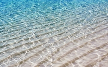
"A tropical beach - must have been a high tide ??" EarthCache
"A tropical beach - must have been a high tide ??"
-
Difficulty:
-

-
Terrain:
-

Size:  (other)
Please note Use of geocaching.com services is subject to the terms and conditions
in our disclaimer.
CWM GWRELYCH - A GEO HERITAGE TRAIL
Discover the internationally important geology of this unique site by following at least some of this amazing geo-trail, using the audio-guides on the footpath.
Situated right on the edge of the South Wales coalfield this secluded valley gives access to rocks that would only be found deep below the valleys of South Wales. Discover coal seams, iron rich rocks and wonderful plant fossils that tell the story of ancient environments and past climate change.This internationally important site has the best sequence of the Upper Carboniferous (Westphalian) rocks in the South Wales Coalfield.
About 500 metres of strata are exposed, a more or less complete representation of the Westphalian age. This is the thickest sequence accessible in natural exposures.
These rocks were formed at the end of the Carboniferous period (359-299 million years ago).
In the early Carboniferous period, limestones were deposited on a continental shelf which deepened towards the south, where there was a major sea area. During earth movements caused by the approach of a continent from the south, shallowing of the sea occurred which led to thick alluvial and coastal plain sediments containing economic developments of coal.

The late or Upper Carboniferous period is often called the Westphalian. When thick sequences of sandstone, siltstone, mudstone, seat earths and coal seams record deposition in a wide variety of environments including coastal plains, floodplains, deltas, river channels, low-lying swamplands and wetland forest. The presence of widespread marine bands indicates periodic inundation by the sea. This was an interval marked by a humid tropical climate and the development of economically important coal deposits that have been exploited in South Wales.
Sedimentation was often cyclic, with a typical cycle comprising a basal coal, overlain by shales, sandy shales and sandstones. These in turn pass up into underclays and root-bearing sediments with an overlying coal reflecting the re-establishment of swamp vegetation and environments.
The excellent exposures found on this Geo-trail are the result of dramatic erosion by glacial and fluvial forces. Ice and water have cut deep gorges and ravines.
Thinner beds of rock formed under marine conditions are visible, as well as bands with fossils of plants, the former indicating flooding of the land.
The rocks were for the most part formed on the floodplains and in river channels and lakes of the equatorial belt of late Carboniferous times, around 320 million years ago. Traces of these coal-bearing deposits and the rainforests of that time are to be found from North America through Europe and into Asia.
Such a well-exposed and complete succession is unique in Europe and is important as a standard from this period, for use as a reference, demonstration and for study.
These rocks contain information about what earth surface environments were like in the past.
A fossil beach is an ancient shore which is preserved in fossil form due to a change in sea level or a shift in elevation. They are formed by shallow water flowing over a bed of sand or other sediments, or by wind-driven wave action in shallow water, again over small sediments. As they are on beaches today.
The formation you see, at about 130 metres above sea level today, was almost certainly caused by shallow, slowly flowing water moving over sandy or muddy areas. At some point in the history of these formations, the ripples were covered with other layers of sediment, without disturbing the patterns we see today. In time there were many other layers deposited here, compressing the previous beds.
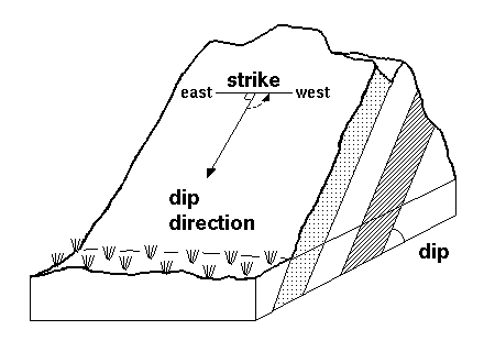
Sedimentary rock units are initially flat lying sequences of deposits. Each layer reflects a change in some aspect of the depositional environment: water velocity, size of sediment fragments, be they clay or boulders, degree of rounding etc.
Once sedimentary rocks are subjected to tectonic forces, they may be folded, tipped on edge, chopped up by faults, or even overturned. The orientation of the rock beds is described using ‘dip’. Dip refers to the downward angle at which the tilted beds now lie. A dip of 90 degrees is vertical. The dip might be stated as “beds dipping 15 degrees to the east”.
Millions of years later, as erosion slowly removed the layers of rock the ripple marks have been exposed and are as we see them today. As erosion is an ongoing process, these remnants will eventually disappear, worn away by the same processes that destroy mountains, turning them into sediments.
GETTING THERE
The main Cwm Gwrelych section is best approached from the north of the village, Pont Walby. You could park in Ynys y Nos Avenue - take care not to bother local residents. There is also a lay-by up the hill, this would be great if you wanted to follow the whole geo-trail.
At the bottom of hill, where the old road that comes from Hirwain enters the village, two footpaths are signed on the road bend. Take the lower path that cuts between several houses follow the path around to the left from where you will be able to see a large Viaduct with a red roofed house to the right. The path is well signposted with really good audio guides at frequent intervals. The eartcache is on the uphill side of this path. The difficulty level is because of walk up!
There are also several traditional caches nearby.
Please EMAIL me the answers ~ From the guidelines: You do not need to wait for permission to log. Requiring someone to wait is not supported by the EarthCache guidelines. You should send your logging task answers , then log the EarthCache. When I review your logging task answers, if there is a problem, I will contact you to resolve it. If there is no problem, then your log simply stands."
PLEASE DO NOT include the answers in your log or upload any photos that would allow others to claim the cache without visiting
- 1. DESCRIBE THE MOST PROMINENT OUTCROP OF ROCK YOU SEE AT THE COORDINATES MENTIONING, SIZE SHAPE, COLOUR, WHAT'S ON THE SURFACE etc..
- 2. ESTIMATE THE SLOPE OF THE ROCK (DIP) AND ITS DIRECTION
- 3. MEASURE THE DISTANCE BETWEEN THE PEAKS OF THE RIPPLES
Go ahead and log your find, I will contact you if there is a problem.
Acknowledgement
Ben Evans (2001) “Upper Carboniferous Stratigraphy and Geological Conservation at Cwm Gwrelych-Nant-Llyn-Fach”. SSSI, National Museum & Galleries of Wales.CCW Contract Science Report No 523
WELL DONE to imbamps on 'FTF" !!!

Additional Hints
(Decrypt)
If you do not email NG NYY then sadly your log will be deleted.
Treasures
You'll collect a digital Treasure from one of these collections when you find and log this geocache:

Loading Treasures