Friendsoftheriver.org define a Floodplain as
By their very nature, floodplains are the low, flat, periodically flooded lands adjacent to rivers, lakes and oceans and subject to geomorphic (land-shaping) and hydrologic (water flow) processes. As distinguished from the floodplain, a river' floodway is the dry zone typically between levees, which is designed to convey flood waters (making wonderful areas for bike trails and parkways because it is only periodically flooded). Unfortunately, a river's floodplain has been viewed as completely separate from a river's active channel. The river and its floodway are usually the focus of construction and control, while fertile, flat and "reclaimed" floodplain lands are usually the focal points for other activities such as agriculture, commerce and residential development. It is only during and after major flood events that the connections between a river, its floodway and its floodplain become more apparent. These areas form a complex physical and biological system that not only supports a variety of natural resources but also provides natural flood and erosion control. In addition, the floodplain represents a natural filtering system, with water percolating back into the ground and replenishing groundwater. When a river is divorced from its floodplain with levees and other flood control facilities, then natural, built-in benefits are either lost, altered, or significantly reduced.
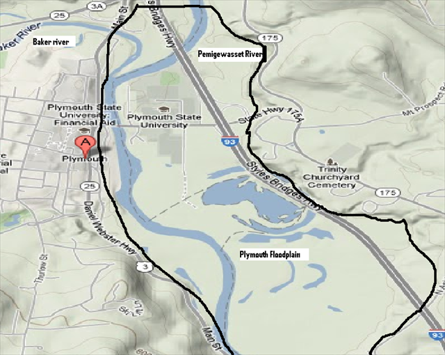
The floodplain here in Holderness/Plymouth stretches roughly from the Route 3/93 intersection to the North where the Baker River and Pemigewasset Rivers confluent and is paralleled roughly by Route 3 to the West and Interstate 93 to the East and as far South as Ashland. I have outlined this area in black on the map, it covers many square miles of land.
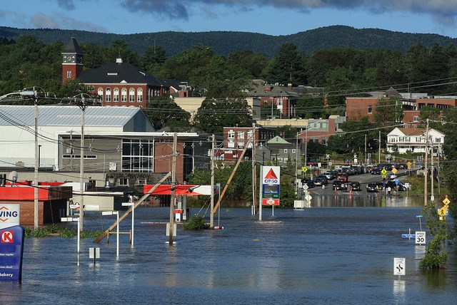
The above picture is where GZ is for this Earthcache, please note the Pemigewasset River is near the top of the photo, just below the white house on the right and the bridge over the river is where the majority of the cars are parked.
This area has seen its fair share of flooding over the years. Most recently during Hurricane Irene in August 2011. The above noted picture was taken during this event.
To get credit for this Earthcache you must go to the posted coordinates and answer the following questions about flood levels, and then email them to me-
a- The flood of 2011 was not the high-water mark at this location. What was the date of the highest recorded level?
b-What was the approximate depth of the water during the 2011 flood?
c-This location has been under water how many times? This is noted by the number of white lines on the wall.
d-DO NOT POST PICTURES SHOWING ANY PART OF THE WALL WHERE THE ANSWERS ARE, YOUR LOG WILL BE DELETED!!
Congrats to DocRoss and buckette for being the FTF!!
references:
www.bbc.co.uk
http://en.wikipedia.org/wiki/Floodplain
www.maps.google.com
http://www.friendsoftheriver.org/fotr/BeyondFloodControl/no5.html
http://www.flickr.com/photos/wasabibob/6092948356/
Congrats to JSLisLost on #3000