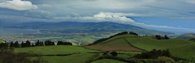

7540 metros (mais coisa menos coisa) - O Estreito de São Miguel
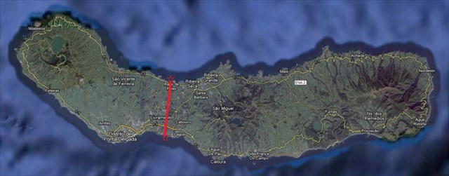
São Miguel é a maior das ilhas do arquipélago dos Açores. Com uma superfície de 746,82 km², mede 64,7 quilómetros de comprimento e tem de 8 a 15 km de largura.
A origem vulcânica desta ilha foi fundamental na determinação das linhas gerais da sua morfologia. Com três maciços vulcânicos principais (Sete Cidades, Fogo e Furnas) a silhueta da ilha torna-se assim bastante montanhosa no acompanhar destes maciços. Havendo alguma continuidade no perfil da ilha desde o seu extremo Nascente até ao maciço do Fogo (passando pela Serra da Tronqueira e pelo maciço das Furnas), no fim deste e dado um maior distanciamento que o separa do maciço ocidental das Sete Cidades, surge uma plataforma baixa e rasa, que atravessa a ilha de Norte a Sul a uma cota razoavelmente constante e que raramente ultrapassa os 200 m de altitude.
É precisamente nesta plataforma em que a ilha de São Miguel se torna mais estreita.
O desafio proposto ao geocacher é contemplar a vista sobre “O Estreito de São Miguel” e se possível tirar uma fotografia que enriqueça a galeria de fotos desta cache.
Informação adicional: As coordenadas do ponto norte mais a sul são:
N 37º 48,795 W 025º 35,032
As coordenadas do ponto sul mais a norte são:
N 37º 44,759 W 025º 35,761
Sugestão:
Para correrias já chegam as do dia-a-dia! Aproveita o geocaching, aproveita as belas paisagens de São Miguel e aproveita para tirares umas belas fotografias. Faz esta cache num dia de céu descoberto e verás que terá outro sabor.

7540 meters (give or take) - The Strait of São Miguel
São Miguel is the largest island of the archipelago of Azores. With an area of 746.82 km², measuring 64.7 kilometers long and 8-15 km wide.
The volcanic origin of the island was crucial in determining the outlines of their morphology. With three main volcanic massifs (Sete Cidades, Fogo and Furnas) the silhouette of the island becomes quite hilly in this massive track. If there is some continuity in the profile of the island from its extreme East to the massive of Fogo (through the Tronqueira Sierra and the Furnas massive), in this order and given a greater distance that separates the massif west of the Sete Cidades, arises a low and shallow platform, which crosses the island from north to south at a fairly constant elevation that rarely exceeds 200m of altitude.
It is precisely on this platform that the island of São Miguel becomes narrower.
The challenge posed to the geocacher is the view over "The Strait of São Miguel" and if possible take a photo that enrich the photo gallery of this cache.
Additional information:
The coordinates of north point further the south are:
N 37 º 48,795 W 025 º 35,032
The coordinates of the south point further the north are:
N 37 º 44,759 W 025 º 35,761
Suggestion:
For stress is enough the day-to-day! Enjoy geocaching, enjoy the beautiful countryside of São Miguel and enjoy taking away some beautiful pictures. Do this cache on a clear day and you'll see that this cache will have a better “flavor”.