This Earthcache is located with permission from Fee and Film Program Manager Tammy Wert in Yellowstone National Park. There is no physical container to find. To get your smiley for the cache, e-mail your answers for the questions below to the cache owner.
Yellowstone National Park is open 24 hours a day, 365 days per year. However, some roads including the road to this earthcache are closed to wheeled vehicles from November to May or June. There is an entry fee to access the park, please visit the Yellowstone National Park website for the latest information.
Yellowstone Lake Facts:
Yellowstone lake is the largest high water elevation (above 7,000 feet) fresh water lake in North America. It covers 132 square miles and is 20 miles long and 14 miles wide. Around the lake is 141 miles of shoreline. At first, Yellowstone Lake was believed to be the deepest in the West Thumb area at 320 feet. More recently with the use of a small submersible robot submarine, the researchers found a canyon just east of Stevenson Island which was 390 feet deep.

The original Yellowstone Lake (formed 600,000 years ago) was 200 feet higher than the lake is now. The lake currently drains north from its only outlet, the Yellowstone River, near Fishing Bridge. The lake remains cold year-round, with an average temperature of 41°F. The surface of the water is cold enough to induce hypothermia, however the lake bed underneath has a very different temperature.
Yellowstone Resurgent Domes:
As little as 5 miles below Yellowstone National Park are two areas where “fingers” of magma are aimed towards the ground’s surface. The heat from these “fingers” causes the overlying land to uplift in two large bulges. These bulges resemble hills, but are termed resurgent domes.
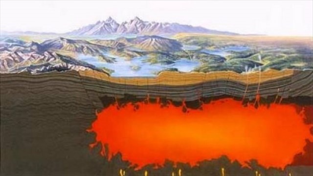
The Sour Creek Dome is near the northeast side of the caldera and above Yellowstone Lake. The Mallard Lake Dome is near Old Faithful. These domes are moving, they rise or fall, with an average net uplift of about one inch per year. From 1923 to 1985, the Sour Creek Dome was on the up rise. In the years since 1986, it has either declined or remained the same. The resurgence of the Sour Creek dome, just north of Fishing Bridge is causing Yellowstone Lake to gradually "tilt" southward. This tilt has caused larger sandy beaches to be formed on the north shore of the lake, and flooded areas can be found in the southern arms.

Yellowstone Lake Floor:
Specific mapping of the Yellowstone Lake bottom has revealed a variety of faults, hot springs and craters. From the hills to the northwest of this location a fracture line runs straight through Lake Yellowstone’s bed and across Steamboat Point. Heat is conducted from magma deep within the earth’s chambers. Due to this heat escaping, steam is sometimes visible in the lake as well as along the shorelines. In 1871 the Hayden Survey team named the point steamboat for the “steamboat” like puffs of steam that come from the nearby thermal areas.
The hottest spot Yellowstone Lake is found at Mary Bay, the bay in front of you, the water temperatures here can be as high as 252° F (122° C). Mary Bay was formed by an explosion 13,800 years ago, which left a 3 mile diameter hydrothermal explosion crater. Hollow pipes or chimneys of silica, which are several feet in height, can be found on the lake bottom floor at Mary Bay. These chimneys are thought to be old plumbing systems of now dormant geysers. Rock spires have been found to be almost 20 feet tall!

To get credit for the cache, please answer the questions below. When answering the questions do your best. It is more important that you learn a new concept about our earth and can apply your knowledge, rather than have a precise answer.
1- Describe the steam (height, width, and force) coming from the closest thermal area on your visit. If the steam is not visible at the time of your visit, what evidence tells you that a lake bed thermal area is there?
2- Applying what you have learned about the geologic forces under Yellowstone lake what is your prediction of its depth in the next 10 years?
3- What do you think the overall stability is of this area?
Thank you for visiting this earthcache. Please send your answers to the above questions to the cache owner. In your "found it" log feel free to write about your experience, but don't include the earthcache answers. Thanks and we hope you enjoy beautiful Yellowstone!

Sources:
http://www.nps.gov/yell/index.htm
http://enjoyyourparks.com/YellowstoneNationalParkLake.html
http://volcanoes.usgs.gov/volcanoes/yellowstone/yellowstone_sub_page_69.
html http://en.wikipedia.org/wiki/Yellowstone_Caldera
http://www.yellowstone.co/lakes.html