Þríhnúkar Volcano EarthCache
-
Difficulty:
-

-
Terrain:
-

Size:  (not chosen)
Please note Use of geocaching.com services is subject to the terms and conditions
in our disclaimer.
Þríhnúkar (Three peaks) formed in separate volcanic eruptions. The peaks are within few hundred metres from each other and line up so they can be clearly distinguished from afar, hence the name. The peaks reach about 550 metres elevation. The youngest one, formed in an eruption about 4500 years ago, is the Þríhnúkagígur crater, with its opening down into the uppermost conduit system of the magma plumbing system of the volcano.

Inside Þríhnúkagígur
The descent into Þríhnúkagígur takes place through the drained conduit system of the scoria cone, where magma flowed upwards during the eruption but later drained out. When coming down into Þríhnúkagígur its inside is seen being coated by a smooth, locally grooved lava lining. After initial narrowing, the entrance widens gradually and pieces of the lining have flaked off locally exposing a thickness of 1 foot or more. Behind it thin (cm) layers are seen that have piled up during the eruption and below them thicker lavas. The lining has fallen off from most of the overhanging walls of the main chamber. It measures about 40 x 60 metres, elongated in the direction of the eruption fissure. The depth is 120 m down to the landing platform but another 80 metres to the lowest point of a passage leading down to the south. At about 70 m below the opening we are at a level with the ice scoured lava of Spor. This continues to bottom on the southeast side of the main chamber. On the opposite side tuffrich fragmental rock, presumably belonging to the subglacially formed westernmost peak of Þríhnúkar, is seen. It slopes upwards some 5-10 m above the debris that has accumulated on the chamber floor. The feeder dyke of the Þríhnúkar crater is seen in the northeast and southwest walls of the chamber. It cuts vertically through the rock as a 0.5-1 m thick fissure fill, with veins branching upwards from it. From the channel which extends down to the south a vertical pipe points 40 m upwards, closed towards the surface. It probably connects to a feed zone of a row of miniature craters 100 m south of the main crater.
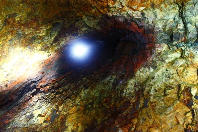
Effloressence minerals occur in cavities and on the walls of Þríhnúkagígur. These probably formed mostly when the interior was hot. The minerals are yellow iron sulphates and sulphur, whitish gypsum, and reddish brown colouring near the opening from oxidation of iron in the rock. Much of this dates from the time of formation of the chamber while the lava was degassing and cooling.

In order to log this cache you do not neccessarily have to take the tour into the volcano, although I can only encourage you to do it. It is worth it! However you have to answer the following questions:
Question 1: Go to the listed coordinates. Describe the color and texture of the stone at the hole! Why do you think is it like this and how will it change in future?
Question 2: In-between what are you standing at the waypoint?
Question 3: At what depth is the landing platform located?
Email the answers BEFORE you log the cache. Please use geocaching.com contact. Do not post the answers with your log. You do not have to wait for our response to log the cache on geocaching.com. If the answers are wrong, we will contact you.
Happy caching!
Additional Hints
(No hints available.)
Treasures
You'll collect a digital Treasure from one of these collections when you find and log this geocache:

Loading Treasures