 Sightseeing - The Old Baden-Baden


Herzlich Willkommen in Baden-Baden und zu einem Altstadt-Cache der besonderen Art.
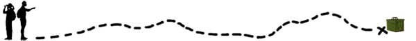
Dieser kleine Rundweg von 1,5 km führt euch zu wichtigen Sehenswürdigkeiten, tollen Aussichtspunkten, wunderschönen Gärten und romantischen Gassen. Auf eurem Weg begegnen euch viele liebevolle Details an Häusern, Brunnen oder Statuen. Einige davon sollt ihr während eurer Tour den Wegpunkten zuordnen, um am Ende Baden-Baden mit einem Smiley zu verlassen.
Wir verzichten bewusst auf eine Zeitangabe, denn es gibt immer wieder etwas in der Nähe zu bestaunen und zu entdecken sowie tolle Einkehrmöglichkeiten. Deshalb lasst euch Zeit und genießt die alten Schätze Baden-Badens.
Der Weg ist nur von 07.00 bis 20.00 Uhr machbar und leider nicht mit dem Rollstuhl oder dem Kinderwagen zu befahren, da einige Treppenstufen zu erklimmen sind.
Auch ist das Mitführen eines Hundes auf dem Teilstück zw. Station 5 und 6 nicht erlaubt (jedoch mit einem kleinen Umweg machbar).
Am Ende dieser Beschreibung findet ihr einen Download Button. Dieser Download beinhaltet die Cache-Beschreibung in praktischem Format sowie bei Interesse geschichtliche Informationen zu den einzelnen Punkten.
Ihr könnt sehr gerne Bilder eurem Log hinzufügen, aber bitte postet keine Bilder der Final Location!
Vielen Dank & Happy Caching!
...hier geht's los:
N 48° 45.743 E 008° 14.309
Los geht es in der Fußgängerzone.
Jaaa, hier darf man durchgehen. Also nur Mut!
Durch die Baldreit-Passage gelangt ihr zu den ersten Hinterhöfen und die Treppe hoch zur
Station 1.
Ab und an ist die Tür zu Station 1 verschlossen. Sollte dies der Fall sein, kommt ihr mit einem klitze kleinen Umweg auch über den Wegpunkt N 48° 45.730 E 008° 14.344 zur Station 1.
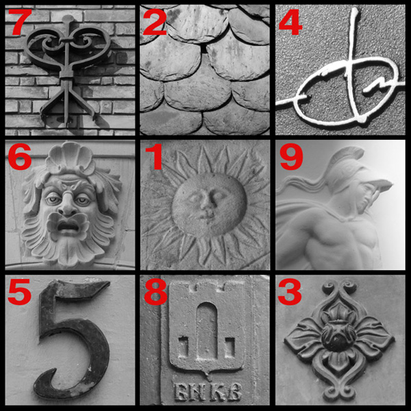
Station 1 - Hinterhof = A
N 48° 45.754 E 008° 14.333
Folgt den Stufen in östliche Richtung und geht weiter durch das weiße Tor (nicht das mit dem Schild Privatgrundstück!) und danach die 8 Stufen runter. Dann gleich links und dann geradeaus durch‘s Baldreit. Dieser Hinterhof war bereits des Öfteren Filmkulisse wie z.B. beim Tatort.
Durch den kleinen Gang im Haus erreicht ihr Station 2.
Station 2 - Baldreit = B
N 48° 45.748 E 008° 14.414
Weiter geht es ein kleines Stück die Straße runter und links durch die Baldreitstraße.
Im Anschluss biegt ihr links in die Jesuitenstaffeln und vor Otto von Bismarck links die Treppen wieder hoch zu Station 3 in einen kleinen, unscheinbaren Garten.
Station 3 - geheimer Garten = C
N 48° 45.732 E 008° 14.440
Die Treppe weiter aufwärts gelangt ihr zur Station 4 in den Hof des Rathauses.
Station 4 - Rathaus = D
N 48° 45.747 E 008° 14.448
Durch den Torbogen würde es links herum auf den Marktplatz und zur Stiftskirche gehen. Wir laufen nun aber rechts vom Torbogen die Steinstraße hinunter und halten uns links, damit wir den oberen Weg am Friedrichsbad entlang laufen. An der nächsten Kreuzung könnte es geradeaus zur Caracalla Therme weiter gehen. Wir biegen aber nach dem Friedrichsbad links ab zu den Römischen Badruinen und der Station 5 an der Fettquelle.
Station 5 - Fettquelle = E
N 48° 45.805 E 008° 14.560
Nun geht es die Dernfeldstaffeln hoch. Oben angekommen laufen wir am Friedrichsstollen vorbei, an der Rückseite des Friedrichsbades und dem Dampfbad. Wir erreichen die Station 6 am Florentinerberg.
Station 6 - Florentinerberg = F
N 48° 45.800 E 008° 14.480
Der Anstieg geht schräg über den Platz die Schlossstaffeln hoch zum Neuen Schloss. Genießt den herrlichen Blick und findet das Bild zu Station 7.
Station 7 - Neues Schloss = G
N 48° 45.826 E 008° 14.455
Ein kleines Stück Richtung Norden könnt ihr einen Blick ins Neue Schloss werfen (hier entstehen ein Hotel und Eigentumswohnungen). Danach biegt ihr ab in die Burgstraße und lauft den Weg abwärts zu einem weiteren Aussichtspunkt an der Station 8.
Station 8 - Brunnen mit Aussicht = H
N 48° 45.826 E 008° 14.338
Weiter durch die Schlossstraße geht es zur Station 9 und einem nicht sofort offensichtlichen, aber sehr interessanten Durchgang, durch den man auch durch gehen darf :-)
Station 9 - (k)ein Holzweg = I
N 48° 45.772 E 008° 14.371
Jetzt müssten alle Bilder den einzelnen Stationen zugeordnet worden sein.
Mit Hilfe der Final-Berechnung sollte es ein Leichtes sein den Geocache zu finden.
Final
N 48° 45. (I+F) (B-D-I) (E-F)
E 008° 14. (H+G) (B-A) (C+H)

Download
Ihr könnt euch diese Cachebeschreibung inklusive historischer Informationen
direkt als PDF zum ausdrucken downloaden.
Das Dokument liegt sicher auf unserem Server.
Groundspeak ist nicht verantwortlich für den Inhalt dieses Links!
* * * * * * * * * * * * * * * * * * * * * * * * * * * * * * * * * * * * * * * * * * * * * * * * * * * * * * * * * * * * * * * * * * * * * * * *
Sightseeing - The Old Baden-Baden
Welcome to Baden-Baden and a special kind of old town-cache. The 1,5 km loop road shows you the importance attractions, great viewpoints, beautiful gardens and romantic alleys.
On your way you will see many lovely details on houses, fountains or statues. Some of them you have to assign to the given waypoints for leaving Baden-Baden at the end with a smiley.
We do not give time disclosures, because on your trip you will see so many things to marvel, to discover or chances to stop off. Therefor take your time and enjoy the old treasures of Baden-Baden.
The Cache is just possible from 7 am to 8 pm. It is not possible to go there with a wheelchair or a baby carriage because you have to take many stairs. Between Stage 5 and 6 it is not allowed to go through with a dog (but it is possible with a detour).
At the end of this listing you will find a download button with the listing and if you are interested with some historical informations of Baden-Baden.
You can add some pictures to your log from your trip, but please do not post pictures from the final location.
Thank you & happy caching!
When you reach a stage you have to look for one of the given pictures which will be next to you.
(e.g.: You are at Stage 1 - backyard=A and you mean to see picture 3, then A=3)
...let's go:
N 48° 45.743 E 008° 14.309
We will start in the pedestrian zone.
Yes! It's allowed to go through. Don't be shy.
Through the Baldreit-Passage you will reach the first backyards and upstairs Stage 1.
Sometimes the door to Stage 1 is locked. If this happens, you can go with a very short detour via the waypoint N 48° 45.730 E 008° 14.344 to Stage 1.
Stage 1 - Backyards = A
N 48° 45.754 E 008° 14.333
Now follow the stairs to the eastern direction and pass the white gate (not the gate with the sign "Privatgrundstück") and then go 8 stairs down.
Go left and then straight through the Baldreit. This backyard was often a movie backdrop, e.g. Tatort.
When you take the small passage you will reach Stage 2.
Stage 2 - Baldreit = B
N 48° 45.748 E 008° 14.414
Now you have to go down the street and take the next street to the left. At the end you take the Jesuiten-Stairs to your left and before Otto von Bismarck take the left stairs to Stage 3 and a small garden.
Stage 3 - Secret Garden = C
N 48° 45.732 E 008° 14.440
Now upward the stairs you will reach Stage 4 and the backyard of the City Hall.
Stage 4 - City Hall = D
N 48° 45.747 E 008° 14.448
Now through the passage you can reach the Marketplace and the Stift Church. But we will take the street "Steinstraße" down and keep left for taking the way next to the Friedrichsbad. At the next crossing there will be straight away the Caracalla Therme. But we will take the left way after the Friedrichsbad to the Roman Bath Ruins and Stage 5 at the Fettquelle.
Stage 5 - Rich Spring = E
N 48° 45.805 E 008° 14.560
Now you have to follow the Dernfeldstairs. On the top we pass the Friedrich Tunnels, the back of the Friedrichsbad and the Stream Bath. At the Florentiner Hill we will reach Stage 6.
Stage 6 - Florentiner Hill = F
N 48° 45.800 E 008° 14.480
The last climb is diagonal over the Marketplace and upstairs the Schlossstairs to the New Castle. At the top enjoy the beautiful view over Baden-Baden and find the picture to Stage 7.
Stage 7 - New Castle = G
N 48° 45.826 E 008° 14.455
Behind you to the north you can have a look into the backyard of the New Castle (at the time there are construction works for a new hotel and private apartments).
When you will follow the "Burgstraße" down you will reach one more viewpoint and Stage 8.
Stage 8 - Fauntain with viewpoint = H
N 48° 45.826 E 008° 14.338
Now you have to follow the "Schlossstraße" to reach Stage 9 and a not obvious, but very interesting passage, and it's allowed to pass :-)
Stage 9 - Wood Passage = I
N 48° 45.772 E 008° 14.371
Now you should found all pictures for every Stage and you should be able to find the Geocache with the final calculation:
Final
N 48° 45. (I+F) (B-D-I) (E-F)
E 008° 14. (H+G) (B-A) (C+H)
Download
You can download this cache description inclusive hostorical information directly in pdf format for printing.
The document is safe on our server.
Groundspeak is not responsible for the content of the link!