Park at the provided coordinates. The parking area is located at the Walnut Creek Gun Club near the bottom of Walnut Creek Hill. Located on Route 20, between Dutch Road and Manchester Road. Drive into the Club lot, then to the left into a small dirt parking area. This area is usually maintained in the winter.
From the parking area head west to the creek. Proceed south under the Route 20 overpass. The fisherman's path is covered with large rocks. Please watch your step! Once you navigate the overpass, follow the creek bed upstream to the cache.
Please stay on the creek bed. There is private property adjacent to the creek and is very well marked. The coordinates are NOT located near the posted property.
Please be courteous, clean and respectful of the area. This area is heavily used during the steelhead run. Please be courteous when fishermen are nearby.
A Little Background Information
The general area at the coordinates above is covered with many sizes of rocks. Notice that most of the rocks in this area are clean from algae and dirt. The water scrubs them clean as it flows by. In fact, many of the smaller rocks have been moved down stream by the force of the water, leaving mostly medium and large size rocks. Notice that not only are most of the rocks of similar size, but they are also flat and rounded off by the erosive potential of the water. Sand and smaller particles entrained in the flowing water act as sandpaper, and accelerate the wearing away of the rocks.
What is it about the water that moves the smaller rocks? It is the velocity of the water that causes a force on the upstream side of the rocks. If this force is large enough it is capable of moving them downstream. A similar process results in the erosion of the remaining rocks as well as the erosion of the bank and streambed itself.
In 1935 Filip Hjulström, a Swedish geographer, published his doctoral thesis which include a graph to determine if a stream will erode, transport or deposit sediment. This graph is known as the Hjulström curve. Below is a simplified version of the curve. Let’s look at what it shows. The y-axis (vertical axis) shows the velocity of the water. (For those who are unfamiliar with the metric units, 1000 cm/sec is equivalent to approximately 22.4 mph). The x-axis (horizontal axis) is a measure of the size of the particle you are analyzing.
If you look at the values on each of the axes you will see that both of them are logarithmic. This is called a log-log plot. If you are not familiar with these they can be a little tricky to interpret. Each major spacing on the graph is 10 times the magnitude of the previous one. If you have trouble with this try this website for a little explanation of how to read the plot.
http://www.lhup.edu/~dsimanek/scenario/errorman/graphs2.htm
This may be a little too technical, but you may be able to find something better if you look up “log-log plots”.
Ok, back to the chart. It is broken into 3 regions:
The PINK region is labeled erosion. If the condition of the stream falls in this region it will tend to cause erosion. This makes sense, because it is at higher velocities.
The BLUE region is labeled transportation. This means that the water will transport actually move particles and transport them downstream in this region. This occurs down to low velocities for smaller particles such as sand, but as the particle size increases the velocity must be much larger to move it. For example, a 0.1 mm diameter particle will be moved by water flowing at about 1 cm/sec, but a 1.0 mm diameter particle will not be moved until the velocity reaches close to 10 cm/sec. For very large particles (over 10 mm diameter) there is only a small window where it will actually be transported by the flowing water.
Finally, the GREEN region is labeled deposition. In the region particles will fall out of the water and be deposited along the bank or in the streambed.
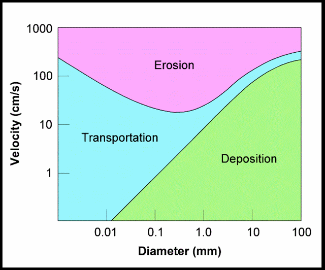
This curve shows the size of the particle and the velocity of the stream as the important parameters in determining whether erosion, transportation or deposition will occur. What is not shown is that there is another important factor involved in the process – the depth of the water. This curve is shown for a depth of 1 meter. Corrections would have to be made if it is significantly different than that.
Rock Sizes
Rocks come in many sizes. The chart below shows generally accepted categories for rock sizes:

Obviously rocks come in all shapes and sizes, not just round. In order to determine what size to use for the “diameter” of the rock, look at the diagram below:

Dimension A is the length or long axis, dimension B is the width or intermediate axis and C is the thickness or small axis. From this information we need to come up with an “equivalent diameter”.
Use the following formula to determine this: √ (4)(B)(C)
This reads: square root of the product of 4xBxC. The units for the answer will be mm.
Estimating The Velocity Of Walnut Creek
For this cache you will estimate the average velocity of Walnut Creek when the water level is about 1 meter deep over the top of the rocks. To do this you will have to perform a calculation. Please try the calculation on your own. If you have problems with it let me know, and I will try to help you out. Let me know how far you got, and what you are having trouble with. DO NOT just ask me to do it for you!!
Below is a more detailed version of the Hjulström curve that you will need for your calculations:

You will need the following equipment: – a ruler. Metric would be preferred, but if you do not have one you can take your measurements in inches and convert to millimeters later.
In order to claim this earthcache..... please go to the posted area, select a rock and perform the following tasks. Please email me your answers:
1. What were the creek conditions during your visit? (i.e. / High or low, Fast or slow moving)
2. Measure the three axis dimensions of your rock (A, B, C). Use millimeters for your units.
3. Determine the equivalent diameter.
4. Classify the rock size according to the size categories in the “rock size” section above.
5. Looking at the curve above you can see that anything that falls below the lower of the two curves will not move. Therefore, that curve shows the maximum velocity that the water can be moving for the rocks to stay where they are. Use that curve to determine the minimum velocity it would take to move the rock you selected. From the curve your answer will be in cm/sec.
6. Convert that velocity to mph. (1 cm/sec = 0.0224 mph).
7. The curve shown above is for a water depth of 1 m. Can you see any indications from the bank that the water may reach this kind of depth at certain times?
Optional: post a picture of yourself and your rock. You can put something near the rock in the picture to give sort of indication of the relative size of the rock. Below is an example of what you might want to do.

Please go ahead and log your visit after sending the e-mail. I will contact you if there is a problem.
