The Chesapeake fault is a LONG dormant fault line. Back some 300 Million years ago, this part of Missouri could not make up its mind on what it wanted to look like. In talking to Missouri registered geologists and from reading material on this fault line. This fault line has MANY different types of faults within the fault. In some spots it’s of a “Horst and Graben” fault type, in other parts it’s a dip slip fault, and yet in other spots it is a compressional fault.

The Chesapeake fault extends for 325 miles from western Kansas to Northern Arkansas with the majority of it within Missouri. Resent geological mapping shows that the Chesapeake fault is not just one fault but many.
“This part of the fault is a compressional fault with a massive up thrown block clearly visible” – Missouri Registered geologist.
"This fault is obvious on both sides of I-44. Higher up-thrown side of the fault is on the southwest side. In the road cut crossing the fault immediately west of Highway N overpass, Rocks dip or slope sharply with Mississippian rocks predominating on the southwest side and Ordovician rocks on the northeast side.” (Beveridge 149)
Different types of Faults
A close look at faults helps geologists to understand how the tectonic plates have moved relative to one another.

Normal faulting – where the crust is being pulled apart, normal faulting occurs, in which the overlying (hanging-wall) block moves down with respect to the lower (foot wall) block.
Reverse faulting – where the crust is being compressed, reverse faulting occurs, in which the hanging-wall block moves up and over the footwall block – reverse slip on a gently inclined plane is referred to as thrust faulting.
Dip-slip movement—Slip of one fault block, relative to the other block, by movement parallel to the dip of the fault. On any inclined surface, such as a fault in the Houston area, it is possible to draw an imaginary horizontal line, termed the strike of the fault, and to draw a second line perpendicular to the strike, termed the dip line. The angle by which the dip line deviates from horizontal is the dip of the fault; it corresponds to the inclination of the fault in nonscientific terms. If movement of one fault block relative to the other block occurs parallel to the dip line, it is termed dip-slip movement.
Downthrown side—The side of a fault that appears to have moved downward relative to the other side.
Upthrown side—The side of a fault that appears to have moved upward relative to the other side. (USGS)

Source: Photo
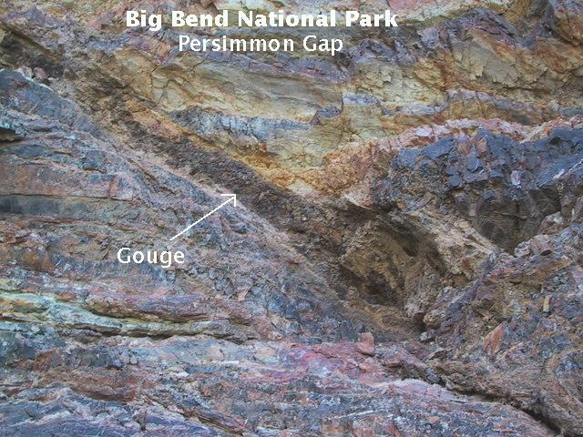
Nature’s crusher
Fault gouge is crushed and ground-up rock produced by friction between the two sides when a fault moves. (USGS)
Source: Web
**Logging requirements**
DO NOT POST ANSWERS IN YOUR LOG.
Send the following answers to me via email.
- Take an elevation reading at “Down thrust”
- While at Waypoint “Down thrust” what does the manmade sign say? **(Absolutely no photos of this sign)**
- Take an elevation reading at “Down thrust-2”
- Take an elevation reading at “Up thrust”
As you cross I-44 on the bridge here be sure to look at the fault and answer the following questions
- ID the fault gouge and tell me what the color is?
- While looking at the fault gouge what size do the rocks that make up the fault gouge look like?
| I have earned GSA's highest level: |
   |