- Deutsch
DAS BOOSER DOPPELMAAR
Bei der Ortschaft Boos liegen zwei weitläufige flache Kessel in der Landschaft, die Booser Maare. Ihre Entstehung verdanken sie dem explosiven Zusammentreffen von aufsteigendem heißen Magma und Wasser. In Aufschlüssen lassen sich noch heute die Schichten beobachten, die während der Vulkanausbrüche abgelagert wurden. Aber die Booser Maare sind auch ein vorbildliches Beispiel für die Gestaltung der Kulturlandschaft. Tier- und Pflanzenwelt werden hier ebenso erläutert wie die Bedeutung der Booser Umgebung zur Römerzeit, als ein Höhenheiligtum auf dem Schneeberg die Maare überragte.
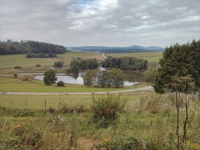
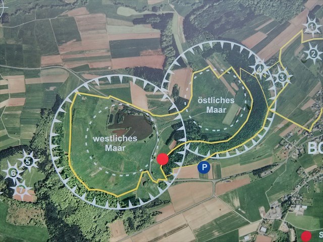
Das Booser Doppelmaar besteht aus zwei verlandeten Maaren, die sich heute als flache Mulden im Gelände westlich der Ortschaft Boos abbilden. Die beiden Maare bildeten sich vor 10.150 bis 14.160 Jahren und gehören zum quartären Vulkanfeld der Vulkaneifel.
Die Maare
Die von Tuffwällen umgebenen Maare bilden kreisrunde Kessel, die auf einer Westsüdwest-Ostnordost verlaufenden Linie liegen. So folgen sie dem variszischen Streichen des Untergrund. Das westliche Maar hat einen Durchmesser von etwa 700 m und ist zwischen 30 und 60 m tief, das östliche ist zwischen 650 und 700 m groß und besitzt eine Tiefe von 50 bis 87 m. Das Gebietist Teil des Vulkanparks und ist 152 ha groß. Es steht als eines der größten Naturschutzgebiete unter Naturschutz in Rheinland-Pfalz. Die beiden Mulden sind sehr feucht, so dass es immer noch Stellen gibt, die dauerhaft eine Wasseroberfläche haben. Die Wasserflächen wurden früher als Fischweiher genutzt, die jedoch später verlandeten und als Wiesen und Äcker dienten. Heute befindet sich im westlichen Maar wieder ein Fischweiher. In der Umgebung der Maare finden sich Tuffgruben, in denen die beim Ausbruch der Maare entstanden vulkanischen Tuffe abgebaut wurden.
Entstehung und Gesteine
Vor ca. 600.000 Jahren begann der Vulkanismus in der Eifel und führte zur Entstehung von zahlreichen Vulkanformen. Der wahrscheinlich letzte Ausbruch, der zur Bildung des Ulmener Maares führte, ist etwa 11.000 Jahre her. Die an Gesteinen der Maare vorgenommenen Datierungen wie auch an organischem Material durchgeführten C14-Datierungen lassen nur für das östliche Maar eine Festlegung des Alters auf 14.160 Jahre vor heute zu. Die Tuffe enthalten Basalt-Bomben mit Nebengestein und großen Olivin-Kristallen. Die Tuffe bestehen zum Teil nur aus magmatischen Kristallen (Kristalltuffe) und enthalten Bruchstücke von Wehrlit und Syenit. In die Tuffe sind an einigen Stellen Lavagänge eingedrungen. Die acht Schlackenvulkane, die sich in unmittelbarem Bereich der Doppelmaar befinden sind mehr oder weniger gleichzeitig entstanden. Dies geschah vor ca. 35.000 Jahren. Einer dieser nach Westen geflossenen Lavaströme erreichte sogar das Tal der Nitz.
(Quelle Wikipedia)
An den angegebenen Koordinaten hast du eine wunderschöne Aussicht auf die Landschaft. Ganz in der Nähe gibt es viele Informationen rund um das Doppelmaar. Zum loggen beantworte mir bitte folgende Fragen:>
- 1.Wie viele Vulkane sind zu beginn der vulkanischen Aktivität auf der nord-östlichlichen Anhöhe vor ca. 35000 Jahren ausgebrochen?
- 2.Wie entsteht ein Schlackenkegel?
- 3.Was ist ein Maar?
- (Optional)Bitte mache ein Foto von dir in der Nähe der Maare und hänge es deinen Log an
- Viel Spass wünscht Vivax77und bobber1
- Logfreigabe erfolgt "nach" einreichen der passenden Antworten -
-----------------------
-----------------------
- English
THE BOOSER DOPPELMAAR
the village of Boos are two spacious flat boiler in the landscape, the Booser maars. They owe their origin to the explosive encounter between ascending magma and hot water. In outcrop can still watch the layers that were deposited during volcanic eruptions. But the Booser maars are also a shining example of the design of the cultural landscape. Animal and plant life are discussed here as well as the importance of Booser area in Roman times, when a height sanctuary on the snow mountain towered over the maars. </ P>
The Booser Doppelmaar consists of two crater lakes silted up, which today represent themselves as shallow depressions in the terrain west of the village of Boos. The two maars formed 10150-14160 years ago and belong to the Quaternary volcanic field of the volcanic Eifel.
The Maars
The two maars form large , surrounded by Tuffwällen circular boiler , which lie on a Southwest - line running east-northeast and then follow the Variscan strike the substrate. The western Maar has a diameter of about 700 m and is between 30 and 60 m deep, the eastern is 650-700 m tall and has a depth of 50 to 87 m. The two wells are very moist so that there are still places that have a permanent water surface. The water areas previously used as fish ponds , which were , however, since silted and as meadows and fields . Today, the Western Maar again a fish pond. In the vicinity of the maars are found Tuffgruben in which the outbreak occurred during the maar volcanic tuffs were mined . The 152 hectares of the area are one of the largest nature reserves in Rhineland -Palatinate protected and are part of the Volcano Park .
Formation and Rocks
The volcanism in the Eifel began about 600,000 years ago and led to the emergence of numerous volcanic forms. Probably the last eruption that led to the formation of the maar Ulmener , is approximately 11,000 years ago. In this time frame the Booser maars are among the recent developments of the volcanic Eifel. The dating of rocks made to the crater lakes as well as performed on organic material C14 datings allow a definition of the age at 14,160 years before present for the Eastern Maar . The tuffs , in which an age of 10,150 years was determined , none of the two crater lakes could be unambiguously assigned . The tuffs contain basaltic bombs with host rocks and large olivine crystals . The tuffs consist solely of magmatic crystals ( Kristalltuffe ) and contain fragments of wehrlite and syenite . In the Lavagänge tuffs are intruded in some places. In the immediate area of the Booser Doppelmaars In total there are eight cinder volcanoes that are more or less simultaneously arose about 35,000 years ago. From one of these a volcano lava has flowed to the west , the current reached the valley of the Nitz .
(Source Wikipedia)
At the given coordinates you have a beautiful view of the countryside. Very close there is a lot of information about the Doppelmaar . "To login please answer me the following questions:>
- 1.How many volcanoes are at the beginning of the volcanic activity on the north-east union hill erupted about 35,000 years ago?
- 2.How is a cinder cone(Schlackenkegel)?
- 3.What is a maar?
- (Optional)Please take a photo of you in the vicinity of the crater lakes and hang it on your log.
- Enjoy wants Vivax77und bobber1
-----------------------
-----------------------