The Gasconade River meander scar.
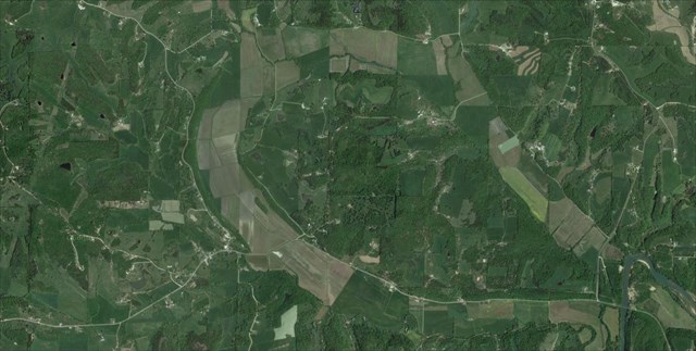
This is the most impressive examples of erosional phenomena in the state of Missouri. (Beveridge 122-123)
In this area the Gasconade River used to flow, following a meander loop. The loop created a lost hill, and then when the river finally eroded through the dolomite rock it created a temporary oxbow lake. However because of deposits from the river it created the elevation to be high on the top part and low on the bottom; thus the lake area drained away back into the river and or evaporated. This caused the meander scar that is visible today.
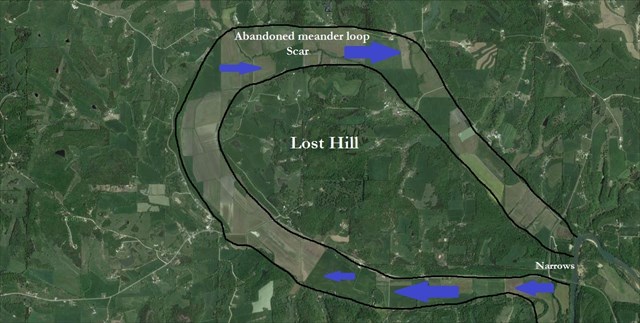
As little as a few tens of thousands of years ago the Gasconade river flowed west at this site, reached the edge of today’s Rich fountain, and swung north and east to complete the loop. There was a very narrow “narrows” here as well.
Eventually the neck was breached either through a natural tunnel or by surface erosion which removed this ridge and allowed the river to take a dramatic shortcut. Regardless of the mode of shortening, because the neck was composed of dolomite, the cutoff was much more difficult to make than others. When it did this it toke a dramatic shortcut. Before breaking through the dolomite rock the river had to go almost nine river miles in the northerly meander loop. By eroding the rock away has saved the river about 8.5 miles of travel.
Meander
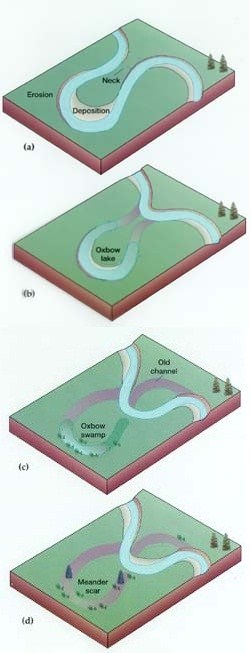
A meander, in general, is a bend in a twisting watercourse or river. A meander is formed when the moving water in a stream erodes the outer banks and widens its valley and the inner part of the river has less energy and deposits what it is carrying. A stream of any volume may assume a meandering course, alternately eroding sediments from the outside of a bend and depositing them on the inside. The result is a snaking pattern as the stream meanders back and forth. When a meander gets cut off from the main stream, an oxbow lake is formed. (wiki, 2013)
This is how a "meander scar" comes to be.
Dolomite
Dolomite is a sedimentary rock similar to limestone, and is composed primarily of the mineral dolomite, CaMg(CO2)3. Dolomite is found in sedimentary basins worldwide. Dolomite and limestone are very similar rocks. They share the same color ranges of white-to-gray and white-to-light brown (although other colors such as red, green and black are possible). They are approximately the same hardness and they are both soluble in dilute hydrochloric acid. They are both crushed and cut for use as construction materials and used for their ability to neutralize acids.
**Logging requirements**
DO NOT POST ANSWERS IN YOUR LOG.
Send the following answers to me via email.
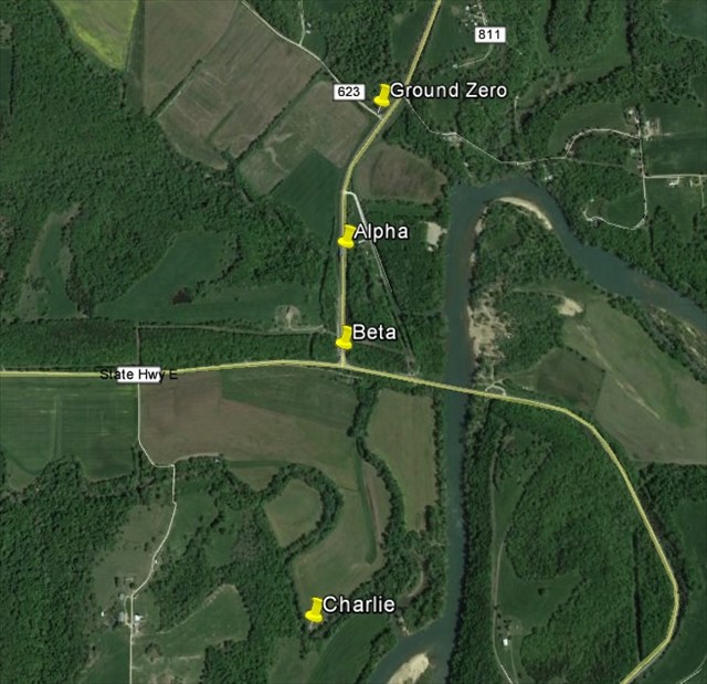
- The text "GC4PECW Missouri's most impressive scar" on the first line
- How wide is the abandoned meander scar on the East side? (While at this earthcaches GZ, measure the distance to waypoint “Alpha”)
- (As you head towards waypoint “Beta” be sure to observe the rock color on BOTH sides of the road.) Is there a difference in the rock color on each side, what color is on both sides, and why do you think that is?
- How wide is the abandoned meander scar on the West side? (While at waypoint “Beta” measure the distance to waypoint “Charlie”)
- How wide are the narrows here? (While at waypoint “Beta” measure the distance to waypoint “Alpha”)
- What is the elevation of the “lost hill”? (While at waypoint “Beta” take an elevation reading, be sure to add 250 feet to that number)
- How much dolomite rock did the river have to cut through, height wise? (lost hill elevation minus river bed elevation, which is 560 feet)
Areal view of your logging tasks
| I have earned GSA's highest level: |
   |
Sources
- Beveridge, Thomas. Geologic Wonders and Curiosities of Missouri. 2nd. Rolla, Missouri: Missouri Department of Natural Resources, 1990. 122-123. Print.
- wiki, . N.p.. Web. 1 Oct 2013. <http://en.wikipedia.org/wiki/Meander>.