|
57. Den Grooten Oorlog : Eerste Slag bij Ypres :
Hill 62
|

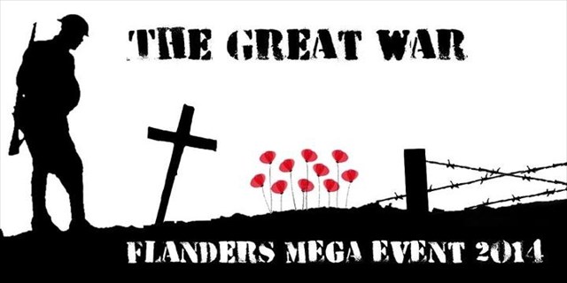
In 2014 wordt het begin van WO I herdacht. Bij deze gelegenheid zullen wij een nieuwe reeks caches uitbrengen, dit langs de volledige frontlijn, van Nieuwpoort tot Mesen.
Ze worden onderverdeeld in verschillende 'veldslagen'. Elke veldslag bestaat uit 8 gebeurtenissen, met aan het eind een bonus. Iedere reeks bestaat uit korte multi's of tradi's.
Het is de bedoeling dat met een tussenperiode van 1 à 2 maanden een volgende veldslag 'uitgevochten' wordt.
Denk er aan : ook al ligt een gedenkteken of begraafplaats schijnbaar midden de velden, er steeds een zeer goed onderhouden pad naartoe loopt.
De caches liggen nergens verborgen op de begraafplaatsen.. De antwoorden op de vragen moeten wel regelmatig op de begraafplaatsen gezocht worden. Respecteer de stilte, aub. Maak je ook het napluizen van de aanwezige registers eigen. Je zal ze hier en daar nodig hebben.
Gelieve GEEN gebruik te maken van stickers in de logboekjes. Breng aub eigen schijfgerief mee en noteer vooral de aanwezige codes. Je zal ze nog nodig hebben !
Indien je over een smartphone beschikt kan je volgende apps erop zetten: GCBuddy en GCC(Pro). Het zal je zeker en vast het nodige rekenwerk uitsparen ...
Bezoek zeker en vast ook de bijgevoegde internetwebsite ! Daar kan je heel wat bijkomende informatie vinden : de historiek van deze reeks caches, handige hulpprogramma's, statistieken ...
[English] - [NEDERLANDS]
Historiek
Dit monument is een eerbetoon aan alle Canadezen die in 1916 hier in de omgeving gevochten hebben. Anders dan het gedenkteken doet vermoeden, bevindt het zich niet op 'Mount Sorrel' maar op de top van de zogenaamde 'Hill 62'. De zgn. 'Mount Sorrel' lag iets ten ZW van 'Hill 62'.
De Canadese 2de divisie beleefde zijn vuurdoop tijdens de gevechten nabij Sint-Elooi (27 maart – 16 april 1916). Deze divisie verloor in die korte periode maar liefst 1375 man. De Canadese 3de divisie kreeg het nog zwaarder te verduren tijdens de 'Slag om de Mount Sorrel' (2 tot 13 juni 1916), in de omgeving van het huidig monument.
Toen vormde 'Sanctuary Wood' het centrum van de gevechten. De Canadese 3de divisie, die uit manschappen bestond die nog niet aan de gevechten hadden deelgenomen, bezette hier het front bij het uitbreken van de aanval maar werd zwaar onder vuur genomen door de Duitsers. Tijdens de daaropvolgende gevechten werd een groot deel van Sanctuary Wood, Hill 62, Armagh Wood en Mount Sorrel ingenomen, dit ten koste van vele slachtoffers. Een slecht voorbereide tegenaanval op 3 juni mislukte. De volgende dagen werden de Canadezen nog verder achteruit gedreven, richting Ieper.
De ondergrondse oorlogsvoering werd de volgende maanden opgevoerd. Tegen februari 1917 werden wekelijks 1 of meerdere mijnladingen tot ontploffing gebracht. Ook bovengronds werden regelmatig aanvallen uitgevoerd.
Een tegenaanval op 13 juni, bedacht door Lt.-Gen. Sir Julian Byng en uitgevoerd door de 1ste Canadese divisie lukte nu wel en werd zo de eerste succesvolle Canadese aanval. De kostprijs was nochtans hoog : in de omgeving van Hill 62 en Mount Sorrel zouden zijn maar liefst 8430 Canadese verliezen gevallen!
'Maple Avenue', de huidige Canadalaan, bestond toen nog niet. Deze laan werd na de oorlog aangelegd op het tracé van de Britse tweede lijn, in functie van de begraafplaats en het Canadees gedenkteken. De weg is aan weerszijden met Canadese esdoorns beplant.
(vrij naar ‘Inventaris van het Wereldoorlogerfgoed’)
Uw missie
WP1
Je staat hier aan het gedenkteken in een park dat op een heuvel werd aangelegd. Het is opgetrokken uit wit graniet, afkomstig uit het Canadese Quebec en weegt bijna 15 ton. Dit monument is een eerbetoon aan alle Canadezen die hier in de omgeving gevochten hebben.
Aan de voorkant, in het midden van de heuvel, zie je een reusachtig trappenterras met vier niveaus, volledig uit breuksteen opgebouwd en met zware roze granieten blokken afgedekt. Vanuit het midden vertrekken hardstenen paden die eindigen op een terras. Dit is afgebakend met een breukstenen muur, afgedekt met hardsteen. Van hieruit heb je een weids zicht op de omgeving.
Op het monolithische blok staat een tekst in letters in vlakreliëf :
op welke lijn vocht het Canadese korps ter verdediging van de stad Ypres ?
A = eerstgenoemde plaats omgezet volgens A=26, B=25 …. Z=1
B = tweede plaats omgezet volgens A=1, B=2 …. Z=26
C = jaar wanneer hier gevochten werd
WP2 Ga of fiets nu naar N50 50.A*3+B/4 E002 56.(C-B)/3+B
We staan hier bij een gedenkteken, geplaatst op een verhoog met twee treden en een kleine gebogen sokkel met daarop een Keltisch kruis.
D = het jaartal op de achterzijde van de sokkel - laatste regel
De cache kan men vinden op N50 .50.(D-46)/80+308 E002 56.D/2-427
[ENGLISH] - [Nederlands]
2014 is the year we commemorate the start of World War I. At this occasion we publish a series of new caches, alongside the Belgian frontline, from Nieuwpoort to Mesen.
They are subdivided in different “battles”. Each battle consists of 8 events, with at the end a bonus. Each series consists of short multi’s or tradi’s.
Remember: although a memorial or cemetery may be located in the middle of the fields, a well maintained walking path leads always to the site.
The caches are never hidden at the cemeteries. The answers to the questions are mostly found at the cemeteries. Please keep your silence. Also accustom yourself to explore the registers.
Please DO NOT USE stickers in the logbooks. Bring along your own pen and note the present codes. You’ll need them.
If you are the owner of a smartphone install the following apps: GCBuddy and GCC(Pro) it will help you with calculations.
Visit certainly our attached website. There you’ll find some extra information, the history of the caches, useful tools, statistics……
History
This monument is a tribute to all Canadians who fought in this area in 1916. Unlike the memorial suggests it is not located on “Mount Sorrel”, but on top of “Hill 62”. The so-called Mount Sorel is located to the SW of Hill 62.
The baptism of fire for the 2nd Canadian division was during the fighting near St Elooi (March 27-April 16, 1916). This division lost in this short period up to 1.375 men. During the battle of Mount Sorrel the 3rd Canadian division had to endure, in the vicinity of this monument, even worse (June 2-13, 1916).
Sanctuary Wood was in the centre of the battle. The Canadian 3rd Division, who didn’t participate in the fighting until then, occupied the front at the outbreak of the attack. They came under heavy fire from the Germans. During the ensuing battle a big part of Sanctuary wood, Hill 62, Armagh Wood and Mount Sorrel were taken at the expense of many victims. A poorly prepared counterattack failed on June 3. The following days the Canadians were driven further backwards in the direction of Ypres.
A counterattack on June 13, conceived by Lt-Gen. Sir Julian Byng was executed by the 1st Canadian division and succeeded. This was the first successful Canadian attack. However the cost was high, 8.430 Canadian losses were counted.
Maple Avenue, the current Canada Avenue, didn’t exist at that time. This avenue was built on the trace of the second British frontline, close to the cemetery and the Canadian memorial. On both sides of the road Canadian maples were planted.
Your mission
WP1
You’re here at the memorial in a park built on a hill. It is constructed in white granite, from Quebec, and weighs nearly 15 tons. This monument is a tribute to all Canadians who fought in the area.
At the front, in the middle of the hill, you see a huge terrace with stairs on four levels, built entirely of rubble and covered with heavy pink granite blocks. From the middle, stone paths lead to a terrace. This is marked out with broken stone wall covered with ashlar stone. From here you have a panoramic view of the surroundings.
In the monolithic block is a text field with characters in relief :
on which frontline the Canadians fought to defend the city of Ypres ?
A = the first location is converted according A: 26, B: 25….Z:1
B = the second location is converted according A: 1, B: 2….Z:26
C= in which year the battle took place
WP2 Go or bike now to N50 50.A*3+B/4 E002 56.(C-B)/3+B
This is a memorial, placed on a platform with two steps and a small curved pedestal topped by a Celtic cross.
D = the year on the back of the plinth - last line
The cache can be found at N50 .50.(D-46)/80+308 E002 56.D/2-427
