La montagne Pelée Traditional Cache
Please note Use of geocaching.com services is subject to the terms and conditions
in our disclaimer.
La cache se situe sur la Montagne Pelée, le point culminant de la Martinique, à seulement 20 minutes environ de marche du stationnement le plus proche. Ainsi vous n'aurez pas besoin de faire toute la randonnée jusqu'en haut pour arriver à la cache.
The cache is located on the Mount Pelée, best known and highest pick of Martinique, at only about 20 minutes of walk from the nearest parking. You will not need to do the entire trail to the top in order to get to the cache.
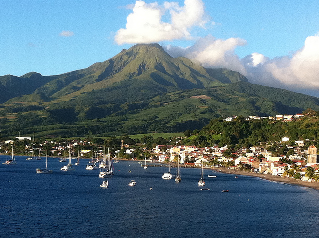
Photo by Clothilde Bonnal on Flickr
DIRECTION : À partir du Morne-Rouge, prendre la route D39 en direction de l'Aileron.
LA MONTAGNE PELÉE PAR L'AILERON
La Montagne Pelée est un volcan actif situé au Nord de la Martinique, sur le territoire de la Commune du Morne-Rouge. Elle culmine à 1,397 mètres d'altitude. La montagne a été rendue tristement célèbre après ses éruptions volcaniques de 1902 qui ont pris la vie à près de 30.000 habitants de la ville de Saint-Pierre et les alentours, situés à ses pieds. Elle fait de nos jours l'objet d'observations attentives des scientifiques et vulcanologues.
La Montagne Pelée est par ailleurs un très beau site de randonnée pédestre avec différents niveaux de difficultés grâce à ses étapes bien définies. La randonnée commence au niveau du stationnement (1er refuge) à 824 mètres d'altitude. La cache se trouve à seulement 20 minutes de marche de là, après le kiosque d'observation. Profitez de la vue panoramique si vous vous y rendez par une journée ensoleillée et dégagée.
__________________________
DIRECTION : From Morne-Rouge, take the route D39 to the Aileron direction.
THE MOUNT PELÉE THROUGH THE AILERON
The Mount Pelée is an active volcano located in the Northern part of Martinique, in the territory of the city of Morne-Rouge. With its elevation at 1,397m (4,583 ft), the volcano is sadly well known due to its eruptions that killed about 30,000 people in 1902. Vulcanologists and scientists are carefully studying the mountain inner activities.
The Mount Pelée is also a wonderful site for hiking with a few levels of difficulty based on the predefined circuits and refuges. The trail starts at the Parking location (1st refuge) at 824m of altitude (2,700 ft). The cache is located at only 20 minutes of walk from there, after the observation kiosk. Enjoy the panoramic views if you get there on a sunny and unclouded day.
Contenu d'origine :
-Log, Crayon boule bleue Cheval, Marque-page magnétic LOVE, Pierre polie noire
-TB Compass (Volcano and Mountain Compass Rose Geocoin) TB5Q1X4
Original content :
-Log, Blue rounded Pencil, Magnetic Bookmark LOVE, Black stone
-TB Compass (Volcano and Mountain Compass Rose Geocoin) TB5Q1X4
Cache placée conjointement avec EveRay
Cache placed with EveRay
Congratulations to the first finders
Félicitations aux premiers à avoir trouvé cette cache
FTF: Vince 64 & lolitadelavega
STF: gaja.kos
TTF: MMXX
Additional Hints
(Decrypt)
Nh cvrq q'ha neohfgr.
Ng gur obggbz bs n yvggyr gerr.
Treasures
You'll collect a digital Treasure from one of these collections when you find and log this geocache:

Loading Treasures