This is another cache in the Explorer Challenge series, originally conceived by PetersfieldPoodlePosse, and based upon British Ordnance Survey grid squares as depicted on Explorer maps.
⚠ NOTE ⚠
You park in the business park at your own risk. The roadways have parking enforcement signs displayed at several points.
The cache is not at the published location which is the centre point of the playing area for this Challenge. But there is no puzzle - the co-ordinates for the physical cache can be found in the Waypoints section below.
To complete the challenge you need to find (or have found) a minimum of 79 different caches.
What is the Explorer 179 Challenge?
The cache is called the Explorer 179 Challenge because each of the 79 different caches you need to have found to qualify must be in a different British Ordnance Survey grid square as depicted on the Explorer 179 - Gloucester, Cheltenham & Stroud.
The caches can be of any type, previous finds qualify (including those finds now archived and events attended (even if you were the host)), in fact just about any cache other than those you have placed yourself can be counted.
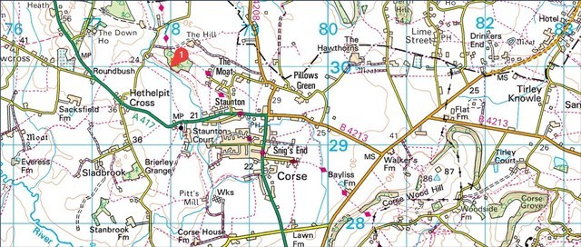
The grids on the map "start" in the north west corner near Staunton at SO 78000 30000
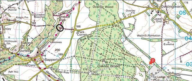
and "finish" in the south east corner a little south of Daglingworth at SO 99000 03000,
giving a possible 27 squares (South to North) by 22 squares (East to West) equals 594 squares in total in which you need to find a cache in 79 different squares to qualify.
For the purposes of this challenge the published co-ordinates of all caches, including Unknown/Mystery and Multi caches are those that are to be used when determining which square a cache counts towards.
How do I know which of the grid squares on the OS map my cache find is in?
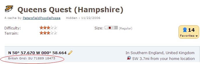
Well, the British OS Grid reference is given at the top of each cache page just below the main co-ordinates, as circled in red below. Or if you click on the streetmap.co.uk link in the "For online maps..." section of the cache page, this will show the location of the cache in its grid square on an OS map.
How to check progress against this challenge
When you have found the 79 caches, you need to provide proof of that fact to be eligible to claim a find on the cache; this can be via one of any number of different methods you may have available:-
- Use the Project-GC challenge checker and take a screenshot of the results, which can then be attached to your log.

- List the 79 cache codes and names and the corresponding grid reference in your found log. e.g.
- GC352ZK Church Micro #1105 - Itchen Abbas SU 53000 32000
- GC20BEY Life of Bryan SU 58000 20000
- Create a public bookmark list
- For users of GSAK, attach the GSAK macro generated image to your log. To do this, you will need to search for and download for the 'ExplorerChallenges' macro.
- Create a Spreadsheet grid of your finds and attach an image of it to your log.
- Use the challenge checker on this site, which requires you to upload your "My Finds" pocket query (Premium members only).
Any finds without proof of qualification will of course be deleted! Have fun!
Congratulations FTF!
🏆 elliott150 🏆
30th December 2013
View the ratings for this cache on handicaching.com.