
 From the parking area, there is an easy trail to follow down to the beach. Please note the warnings and cautions regarding the dangerous surf, especially during storms.
There is an information sign (36.66016389, -121.82109722) in the parking lot that provides a brief overview and diagram of that provides larger diagrams to look at.
At the coordinates you should easily be able to identify the three main parts of beach topography: the backshore, the foreshore, and offshore.
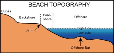 The backshore includes the dunes and extends to the shoreward edge of the berm. You walked through the dunes getting to the coordinates. The berm is the relatively flat sandy area between the dunes and the berm crest. At the berm crest, the slope of the beach becomes significantly more steep. The width of the berm changes seasonally. During the summer it is wider than during the winter.
The foreshore begins at the berm crest and extends down to the low tide line. This section of beach usually slopes downward at a uniform level. Because of the tides, this section of beach is periodically below sea level or above sea level.
Beyond the foreshore is the offshore beginning at the low tide line and extending off shore. This section of the beach is always below sea level but constantly affected by the waves. The offshore profile changes seasonally. During the summer, it is a relatively uniform slope down. During the winter, a trough (low point) forms with mounds of sand (bars) eroded from the berm shoreward and seaward of the trough.
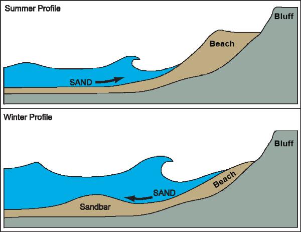 The seasonal changes noted above are caused by the different energy levels of summer and winter waves. Winter storms generate waves with more energy than summer waves. The difference in energy between summer and winter waves drastically changes the look of the beach. The winter waves erode sand off the beach and store it in offshore bars. The winter waves have enough energy to not only pick up sand as they come into shore but also transport it off of the foreshore. The largest storm generated waves also erode the face of the berm crest, reducing the width of the berm. The sand is then deposited in sandbars off-shore. During summer, the waves are milder. These waves have enough energy to transport sand as they come into shore. As the water flows back to the ocean, there is not enough energy to transport as much sand as the wave brought onto the forshore back off shore, resulting in a net gain of sand. This results in the gradual build up of the berm crest and the berm widens for the summer.
Logging requirements:
Send me a note with :
- The text "GC4TH8H Fort Ord Dunes Beach Topography" on the first line
- The number of people in your group (put in the log as well).
- Post the coordinates of the transition from the backshore to the foreshore?
- Does the beach profile you see resemble the summer or winter profile?
The following sources were used to generate this cache:
- http://coastalchange.ucsd.edu/st3_basics/beaches.html
- http://www.ocean.uni-bremen.de/EInfo/materialien/elemOc/top12-17/topic14.html