|
SALTO DO YUCUMÃ
|
|

O Salto do Yucumã é a maior queda de água longitudinal do mundo com cerca de 1800 m de extensão e atinge os 20 m de altura no seu ponto mais alto. Trata-se de uma falha basáltica que praticamente engole o rio Uruguai, o maior rio do estado brasileiro do Rio Grande do Sul e que passa de uma largura de 450 para 25 m neste local. A profundidade máxima da fenda chega a atingir os 120 m. A massa de água divide-se em 24 cascatas individuais com uma largura que varia entre os 2 e os 60 m.
O seu nome provém do tupi-guarani e significa "O Grande Roncador".
|
|

The Yucumã Jump it's the largest longitudinal waterfall in the world with about 1800 m long and reaching up to 20 m tall at its highest point. It's a basaltic fissure that practically swallows the Uruguay River, the largest river in the Brazilian state of Rio Grande do Sul that shrinks from 450 to 25 m wide at this site. The rift's maximum depth reaches up to 120 m. The mass of water is divided into 24 individual falls with a width that varies between 2 and 60 m.
Its name comes from the Tupi-Guarani and means "The Great Snoring". |
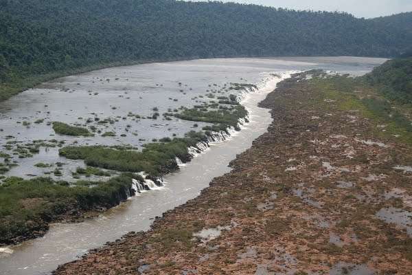
Vista aérea do Salto do Yucumã
Yucumã Jump aerial view
|
Localização
Localization
|
|

O salto encontra-se no Parque Estadual do Turvo, situado no município de Derrubadas, noroeste do Rio Grande do Sul, Brasil, e protege o que resta da Floresta do Alto Uruguai, a maior floresta do Rio Grande do Sul. O rio divide o Brasil e a Argentina, sendo que a cascata pertence ao lado argentino, no Parque Provincial de Moconá. (No idioma indígena "Moconá" significa "O que tudo engole")
Porém, o espetáculo natural só é visível do lado brasileiro e em épocas de baixo caudal. Quando o caudal é alto, especialmente durante o inverno, todo o leito fluvial é enchido de água, cobrindo a cascata.
|
|

The jump is situated at the Turvo State Park, in the municipality of Derrubadas, northwest of Rio Grande do Sul, Brazil, and protects what remains of the Forest of Alto Uruguai, the largest forest in Rio Grande do Sul. The river divides Brazil and Argentina, but the waterfall belongs to the Argentinian side, in Moconá Provincial Park. (In the indigenous language "Moconá" means "That who swallows everything")
However, the natural spectacle is only visible on the Brazilian side and at times of low flow. When the flow rate is high, particularly during the winter, the entire riverbed is filled with water, covering the waterfall. |
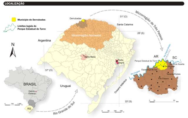
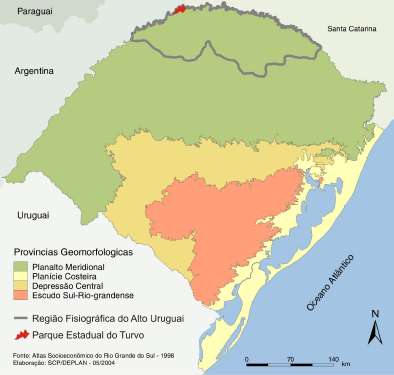
Localização do do Parque Estadual do Turvo
Localization of Turvo's State Park
|
Geomorfologia do Rio Grande do Sul
Geomorphology of Rio Grande do Sul
|
|

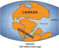
| O parque pertence ao Planato Meridional, uma extensa região formada por planícies basálticas (cerca de 1,2 milhão de km²) intercaladas com camadas de arenito resultante da erosão provocada pelos rios, pelo vento, pela chuva e pelo avanço e retrocesso do mar. O basalto é uma rocha de origem vulcânica proveniente de gigantescas erupções vulcânicas que datações radiométricas situam entre 137,4 e 128,7 milhões de anos. Estas erupções ocorreram no centro do actual Brasil, formaram uma das grandes províncias ígneas do mundo e contribuíram para a separação do supercontinente Gondwana, dividindo o que hoje conhecemos como os continentes da América do Sul e da África. |
 |
|
|

| The park belongs to the Southern Plateau, an extensive region formed by basaltic plains (about 1.2 million km²) interspersed with layers of sandstone resulting from erosion caused by rivers, wind, rain and the sea's advances and retreats. Basalt is a rock of volcanic origin from massive volcanic eruptions that radiocarbon dating puts between 137.4 and 128.7 million years ago. These eruptions occurred in the center of modern Brazil, formed one of the largest igneous provinces in the world and contributed to the breakup of the supercontinent Gondwana, separating what we know today as the continents of South America and Africa. |
 |
|
|
Formação
Formation
|
|

Ao longo de milhões de anos, a região foi afectada por movimentos da placa basáltica que a quebraram produzindo desníveis. Estes, por sua vez, deram lugar a saltos e cascatas de diferentes magnitudes, que foram sendo erodidos pelos rios. A fenda basáltica que dá corpo ao Salto do Yucumã formou-se há cerca de 200 mihões de anos a partir de um dos inúmeros movimentos verticais que fracturaram o planalto basáltico no sentido NE - SO. |
|

Over millions of years, the region was affected by movements of the basaltic plate which broke it and produced steps. These, in turn, gave rise to jumps and waterfalls of different magnitudes, which have been eroded by rivers. The basaltic rift that forms the Yucumã Jump was formed around 200 million years ago from one of the numerous vertical movements that fractured the basaltic plateau in the NE - SW. |
|
Informações
Informations
|
|

O Parque está aberto para visitas de quarta a domingo, das 8h00 às 17h00 horas. O preço de cada entrada é cobrado por veículo:
- Moto - R$ 6,82
- Carro – R$ 11,24
- Utilitário leve (Van) - R$ 37,52
- Micro-ônibus - R$ 74,85
- Ônibus ou caminhão - R$ 149,49
O Ponto 1 corresponde à entrada do parque. O trajecto até ao rio tem cerca de 15 km e acaba numa zona de lazer onde se pode deixar o veículo. A partir daí, existe um trilho até ao rio.
Para se poder ver o Salto do Yucumã, aconselha-se o contacto prévio com o parque, pois o nível da água poderá estar elevado e inviabilizar a sua visualização. No entanto, o Parque não é apenas a cascata e vale a pena ser visitado. A earthcache pode ser registada mesmo não sendo possível ver a cascata.
Pede-se o maior cuidado na aproximação à cascata. As crianças devem estar sempre acompanhadas de adultos responsáveis.
|
|

The Park is open for visitors Wednesday through Sunday from 8:00 to 17:00 hours. The price of each entry is charged per vehicle:
- Moto - R$ 6.82
- Car - R$ 11.24
- Lightweight utility (Van) - R$ 37.52
- Minibus - R$ 74.85
- Bus or truck - R$ 149.49
Point 1 corresponds to the park entrance. The road to the river is 15 km long and finishes in a recreation area where you can park the vehicle. From there, there is a trail to the river.
To view the Yucumã Jump, it is advisable to first contacting the Park, because the water level may be high and derail your viewing. Nevertheless, the Park is not just the waterfall and well worth a visit. The earthcache can be logged without the need to see the waterfall.
People must have the utmost care when approaching the waterfall. Children should always be accompanied by responsible adults. |
|
Perguntas
Questions
|
|

Para que o seu registo possa ser validado, deverá ler com atenção a descrição desta cache e responder às seguintes questões:
- Daquilo que pode observar à sua volta, qual a rocha predominante junto ao salto do Yucumã e qual a sua cor?
- Descreva duas características visíveis na superfície das rochas que tem de pisar até chegar ao rio. Pode tirar fotos que exemplifiquem essas características.
- A partir das coordenadas, qual a diferença de altura estimada em metros entre o lado argentino e o lado brasileiro? Pelo que leu na descrição da earthcache, descreva, por palavras suas, o que causou esta diferença de altura.
|
|

For your registration to be valid, you must read attentively this listing and answer the following questions:
- From your observations at the site, what is the predominant rock next to the Yucumã Jump and what's its color?
- Describe two features visible in the surface of the rocks that you have to step up to get to the river. You can take some photos to exemplify those features.
- What's the estimated difference in meters between the Argentine side and the Brazilian side? From what you read in the listing, describe, in your own words, what caused this difference in height.
|
