This Earthcache is to be completed on the beach. There is no need to walk onto the shoal! Doing so is extremely dangerous and has cost people their lives.
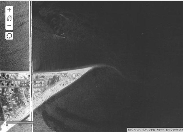
An imaginary line connecting Conimicut Point to Nayatt Point across the bay forms the mouth of the Providence River and the head of Narragansett Bay. At this dynamic interface, a curious geologic feature is present. Extending approximately 1000 meters from Conimicut Point, the Conimicut Shoal appears as a dangling finger in Narragansett Bay. The shoal is clearly visible in satellite imagery:
 An aerial photograph of the Conimicut Shoal
Color infrared imagery does a better job showing the extent of the shoal:
 CIR imagery of Conimicut Shoal
Shoal Formation
Shoals form due to a process called deposition. As surface waves move into shallow water, the velocity of the waves decrease and any suspended sediment in the water column is deposited. Sediment moving along the sea floor (bed load) is also deposited.
The sediment that is deposited provides an indication of the energy of the coastal environment. Very low energy environments will allow clay and silt to settle out of the water column, forming mudflats.
 Extensive mudflat at Bottle Beach in Washington
Coastal environments with higher energy levels are too turbulent for silt and clay to settle. Instead, fine sand particles are deposited.
 An example of fine sand. Particles are 1/8 - 1/4 mm in diameter.
Environments with increasing energy levels only allow medium and coarse sand to be deposited.

 Typical beach sand: 1/4 - 1/2 mm grain size diameter Coarse sand: 1/2 - 1 mm grain size diameter
The Role of Longshore Drift
The second factor in shoal formation is longshore drift. Longshore drift is the transportation of sediment along a shoreline at an angle to the shoreline. Prevailing wind direction is the dominant factor that influences the angle at which the weaves break on shore. The oblique angle of the crashing waves pushes sediment along the shoreline.
 Longshore drift causes sediment to move parallel to the shoreline
When the angle of the coastline changes (typically 30° or greater), longshore drift may continue past the shoreline, creating a shoal, sometimes known as a spit.
 Shoals/spits form when longshore drift continues beyond the coastline
Your Assignment
To log this Earthcache, email me your answers to the following 3 questions:
1) Examine the sediment of the beach near where the shoal begins. Using the information and pictures from the Earthcache description, describe the type of energy environment (low, medium, high) under which the Conimicut shoal has formed. Explain your reasoning, focusing on grain size of the sediment.
2) Why is the Conimicut Shoal positioned from northwest to southeast?
3) The Conimicut Shoal appears to have increased in size when compared to 1939 aerial photos. Can you think of any possible reasons why this increase has occurred?
 1939 Aerial Photo of Conimicut Point
Additional Info
The Conimicut Lighthouse was originally constructed in 1868 to aid boats navigating the treacherous waters at the head of Narragansett Bay. Rock outcrops, swiftly changing currents, and the Conimicut Shoal were hazards that claimed many boats. To read some additional information about the lighthouse, please visit the "Related Web Page" link at the top of the cache listing.
To repeat, walking onto the shoal is strongly discouraged. Although the shoal appears well above the water at low tide, the tide quickly changes here, submerging the shoal beneath swiftly moving water. In addition, the sides of the shoal are prone to collapse.
Earthcache guidelines state that you do not have to wait for a reply from me to log your visit. You are free to log as long as you email your answers. Enjoy!