Logging Requirements
Below follows a history of the area and evolution of the riverfront. As you read through the description, you will be asked to answer several questions (in red in the text below). I have summarized them here for your convenience:
*Note: The city is currently developing the waterfront area. Access to the posted cache coordinates may be blocked by construction. If this is the case, obtain an elevation reading as close to the waterline as possible, or just estimate.
- Note the elevation at the cache coordinates and compare to waypoint 1. What is the elevation difference? Or, walk from the riverfront to waypoint 1 and estimate the height differential. This would be the approximate height of the river bluffs that once existed here.
- How much of his stone foundation did William Ramsey expose through the process of "banking out"?
- What do you estimate the grade of banked-out land between Fairfax and Lee Streets on Ramsey Alley?
- What is the maximum reading of the flood gauge? Would a major flood or a flood topping the gauge have breached the height of the original river bluffs?
Please submit answers to these questions via my profile at time of logging the cache. I will contact you if any answers are incorrect. All "found it" logs posted without an accompanying e-mail will be deleted.
The Original Shoreline
It is clear that the Alexandria waterfront today is not where it was when the town was first established in 1749. Now the central waterfront is on generally level ground and runs in roughly a straight line along the Potomac River from Franklin Street in the south to Pendleton Street in the north.
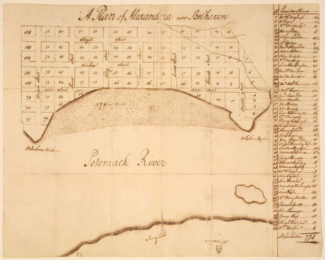
In 1749, however, the town was situated on high bluffs that formed a crescent-shaped bay with two points of land backed by abundant woods and fertile fields. The point at the south end of the bay was Point Lumley, located at the foot of Duke Street, and the northern point was West’s Point, at the foot of Oronoco Street. A 17-year-old George Washington surveyed the shoreline before the city’s founding. Below is a copy of his plan for the city, showing the original crescent shape of the harbor.

Begin this cache at the river's edge, just beyond the foot of King Street (at the cache coordinates). Look towards Alexandria--if you stood at this point in 1749, you would be in the Potomac River looking at bluffs some 2 blocks distant. This conjectural drawing of early Alexandria by Elizabeth Luallen shows the bluffs of Alexandria as they were in the mid-18th century.

If your GPS has the capability, note your elevation at this point, and then proceed up King Street to Fairfax Street (waypoint 1). Your walk will bring you uphill to the original height of the bluffs. According to your GPS, how high above the river do you now stand? Or, given the view down King Street and your walk uphill from the shore, what is your estimation of the original height of the bluffs?
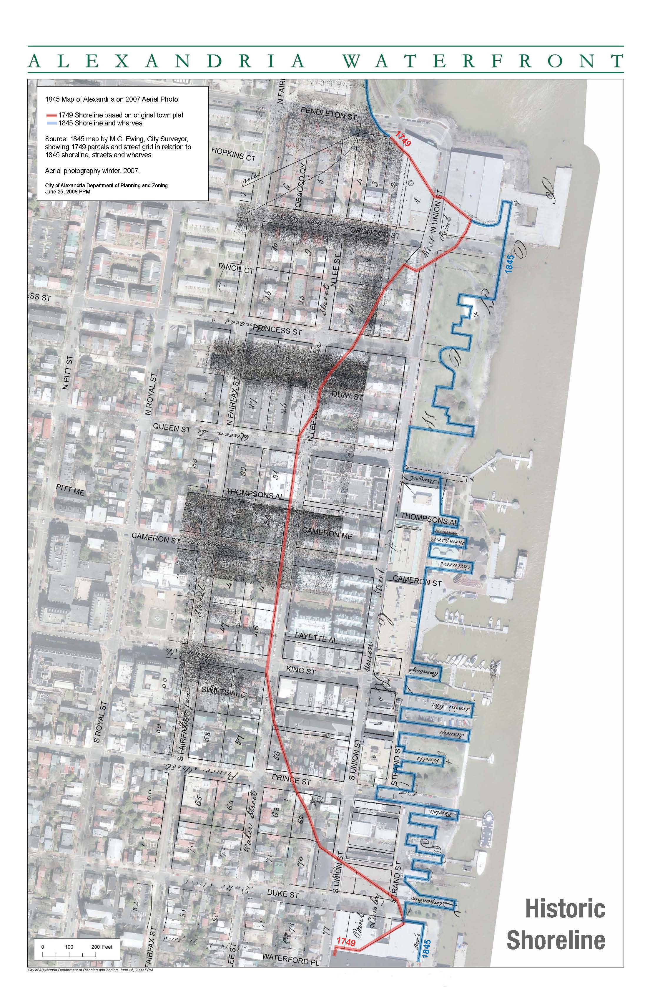
Originally, Oronoco and Duke Streets extend into deep water. Much of the area between them was swampy flatland. It was only gradually that the points were extended and the bay was filled in by a process known as “banking out.” Important to this process of expanding the land on which Alexandria was located and arriving at the waterfront as it exists today was the building of wharves.
Long wharves were erected at Cameron Street in 1759 and just north of Queen in the mid-1760s. By 1763 the town had expanded, its population of over 1,200 lived along the bluff looking down on their wharves and warehouses below. The General Assembly of Virginia authorized the town to connect the two sections of Water (now Lee) Street and to create Union Street by landfill. By 1782 property owners cut away the riverbank, providing fill for the cove.
Ramsey House
At waypoint 1 on the northeast corner of Fairfax and King Street sits the house of William Ramsey, a merchant and ship owner. Ramsey came to Virginia from Galloway, Scotland, and became one of the original promoters of Alexandria and one of its most beloved citizens. At the first land auction here in July 1749, Ramsey bought Lots 46 and 47 and, according to tradition, owned the first house in the new town, now the Alexandria Visitors’ Center.
The deeds reserved for Ramsey “the absolute right to take away as much earth or dirt from said ground as will be sufficient to be applied towards filling my Wharf and Piers....”
Unlike his neighbors, Ramsey had his house face the river, not the street. He extended lot 46 into the Potomac by “banking out” the high ground, cutting it down to fill in the mudflats (and in the process revealing the stone foundation of his own house) until his wharf reached navigable water. The land under the north side of lower King Street is Ramsay’s “made ground.” How much of his own stone foundation did Ramsey expose in his “banking out” efforts? This will give you an idea of the original land height and the transformation wrought by the "banking out" process.
Riverfront Transformation
The “banking out” that precedes the driving of wooden piles for a wharf was an arduous and risky process. Earth was sliced from the bluff, loaded on wooden carts, and dumped at the river’s edge. At least one worker was lost under a toppling bank. The following image shows the building of wharves (shown in orange) and filling-in of the river (shown in red and green).
In 1789 Alexandria’s population reached 3,200. The port was the fifth busiest in the U.S. Many new blocks had been created by “banking out.” A waterfront lane, the Strand, was built between Cameron and Duke.
By the end of the 18th century, much of the waterfront had been filled in, and by 1791, Union Street was established. The process of wharf creation and land-filling continued, creating both the land that now sits under 105 N. Union St., and the Strand.

Make your way back towards the waterfront via Ramsey Alley, which is just north of King Street (beginning at waypoint 2). Some of the buildings fronting this alley were Ramsey's original warehouses. You will notice that the majority of the elevation change occurs during the first block of your walk between Fairfax and Lee (formerly Water) Streets. What is your estimate of the grade of the "banked out" land between Fairfax and Lee? (Divide the height difference by the distance covered to get a percentage.) Steep hills like this are a result of the efforts to destroy the bluffs.
Potential Problems with Filled Land
There exist several threats to reclaimed land. It is highly susceptible to soil liquefaction during earthquakes, which can amplify the amount of damage that occurs to buildings and infrastructure. Subsidence (which is the downward motion of the earth’s surface) is another issue, arising from soil compaction on filled land. The filled land of Old Town’s greatest threat is the increased danger from flooding.
Proceed to the northeast corner of King and Union Streets (waypoint 3). Here you will find a flood gauge used to measure the Potomac during high water. What is the maximum reading of the flood gauge? If flood waters reach just half of this height, it is considered a "major flood" by the national weather service. Given the estimated height of the river bluffs, would they have held back the Potomac during a major flood? Would they have been breached by a flood topping the flood gauge?
References
Much of the information contained here is taken from the City of Alexandria's "Historic Alexandria" page:
https://www.alexandriava.gov/historic/default.aspx
