Welcome to McKelvey Woods. Phase I of this trail was called the McKelvey Woods Trail when it officially opened on April 5th 2014. It began at the Maryland Heights Aquaport and ran 0.8 miles along Fee Fee Creek. This cache was placed at the end of the Phase I Trail.
On 6-14-18 the Phase II extension of this trail connected Aquaport to Creve Coeur Lake Park for a total distance of 2.7 miles. The Phase I and Phase II trail name was then changed to the Fee Fee Greenway. The surface is either concrete or asphalt. Wheel Chairs, Dogs, Bicycles, and Roller Blades are allowed on the trail. Restrooms are nearby at Dogport and the Maryland Heights Community Center. Hours of trail use are from 30 minutes before sunrise to 30 minutes after sunset.
Coordinates are given for the turn into the Aquaport parking lot on McKelvey Road. These coordinates are also the location of the Aquaport Trailhead which begins on the sidewalk. After you make the turn from McKelvey Road into the parking lot, make an Immediate Right turn to access the parking lot spaces. The "Do Not Enter" signs refer to the dropoff traffic in front of the Aquaport so that it moves in a Counter Clockwise direction.
Follow the sidewalk North from the Fee Fee Greenway trailhead sign a short distance to where the trail descends to Fee Fee Creek. If you prefer a longer walk, you can take the trail from the Creve Coeur Lake Park trailhead which is at the disk golf parking lot (see Parking Coordinates).
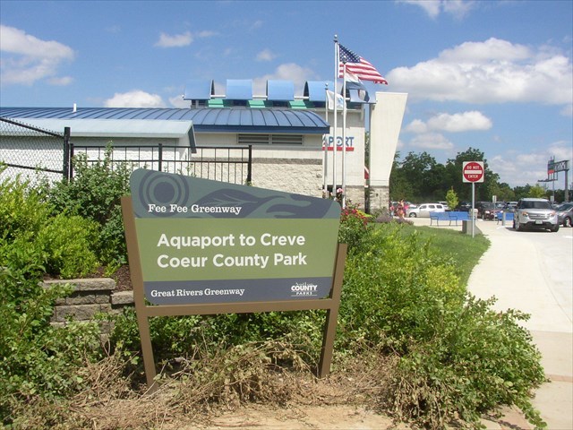
The Sign that Marks the Aquaporat Trailhead, and the Turn into the Parking Lot
A short walk headed North from there takes you to McKelvey Woods. A reference point is given where the trail leaves the sidewalk.

Trail Leaves Sidewalk , Looking North
The trail is considered wheel chair accessible, however be forewarned that there is a L o n g . . . gradual Descent at the beginning of the trail, which becomes a L o n g . . . Ascent on the return trip. You can reach the cache without leaving the trail. Permission to place the cache was obtained from the Maryland Heights Department of Parks and Recreation.
McKelvey Woods was part of the 182 acre plantation owned by William McKelvey from 1836 to 1859. It was near the estate of Walter H. Dorsett. Both are familiar names today in Maryland Heights. McKelvey’s plantation crops included wheat, corn, oats, Irish potatoes, and hay. Mr. McKelvey, like many early settlers in the Maryland Heights area is buried in Fee Fee Cemetery, one of the oldest in the county. The land for Phase I was donated by the Valenti family which has owned portions of the estate since 1940. The Phase I trail follows Fee Fee Creek. A program is in place to revitalize the creek and the wet lands surrounding it. Fee Fee Creek is a tributary to Creve Coeur Creek which flows directly to the Missouri River.
CONGRATULAIONS TO Karen-Lonnie FOR FIRST TO FIND !!!