This cache is placed with permission.
The site is open from sunrise to sunset (no night caching, please).
This stretch of trail is regularly enjoyed by hikers, bikers, and visitors exploring the South River corridor. Please help protect the area and return the cache exactly as found so others can enjoy the experience.
Cell service may be limited in various areas along the AMNHA Geo-Path. Please plan accordingly.
Questions or need to share a challenge with a cache?
Send us a message in the Geocaching app
Remember to bring a pen, items to trade, and follow recommended
Geocaching Etiquette
.
CONGRATULATIONS TO JERDAWG AND THEMOIETY FOR BEING THE FTF!
AMNHA Geo-Path Series
AMNHA: Foundations and Bridges
Passport: Geo-Path
Series: South River Stroll
Password: Located in the logbook
Hours: Sunrise to Sunset
Parking Options: See waypoints
Foundations and Bridges
This stop along the South River brings together two ideas that quietly shape this area: strong foundations and meaningful connections.
The nearby bridge is more than just a crossing. It links trails, communities, and experiences across the Arabia Mountain National Heritage Area. It also leads visitors to a peaceful place to pause, look out over the river corridor, and take in the landscape from a different perspective.
The viewing area nearby offers a good reminder that trails are not only built for movement, but also for reflection. Places like this invite you to slow down, notice your surroundings, and appreciate how thoughtful design can help people connect with nature.
Keep an eye on the details here. Between the bridge, the overlook, and the stones that help anchor the landscape, the title of this cache may begin to make even more sense.
200th Mile of Trail
This area marks the PATH Foundation's 200th mile of trail, a milestone that reflects years of work building off-road trails and greenways throughout the greater Atlanta region.
Through these connections, the PATH Foundation has helped create places where walkers, runners, cyclists, and families can experience scenic routes, protected landscapes, and a stronger connection to the outdoors. The Arabia Mountain PATH and South River trails are part of that larger vision.
Here, that work is easy to appreciate. The trail invites exploration through wooded stretches, river views, and quiet places to stop along the way.

PATH Foundation 200th Mile marker, painted on the trail a short walk from the bridge (see waypoint).
The Bridge and Overlook
The Rockdale River Trail connects with the South River Trail and the Arabia Mountain PATH, guiding visitors through beautiful natural areas now protected within the Arabia Mountain National Heritage Area.
The pedestrian bridge over the South River is one of the longest along the PATH and stands out as a memorable feature of the trail. Built with weathering steel, it was designed to develop a stable rust-like finish over time, blending naturally with the landscape while reducing long-term maintenance.
Nearby, the sitting and viewing area offers a peaceful place to rest and enjoy the river setting. Together, the bridge and overlook reflect the spirit of this cache title, combining structure, connection, and a lasting sense of place.
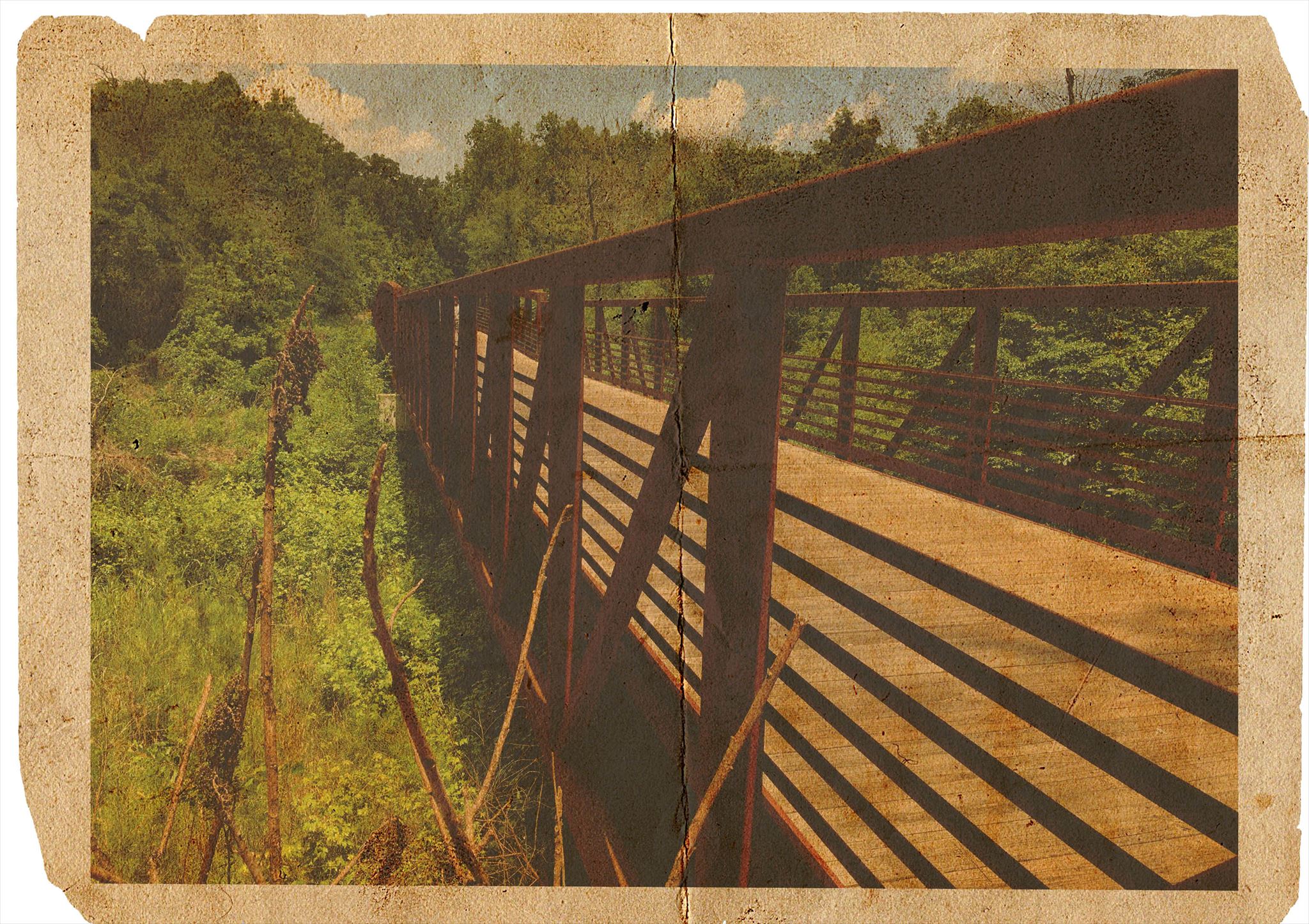
View of the bridge from the other side of the river
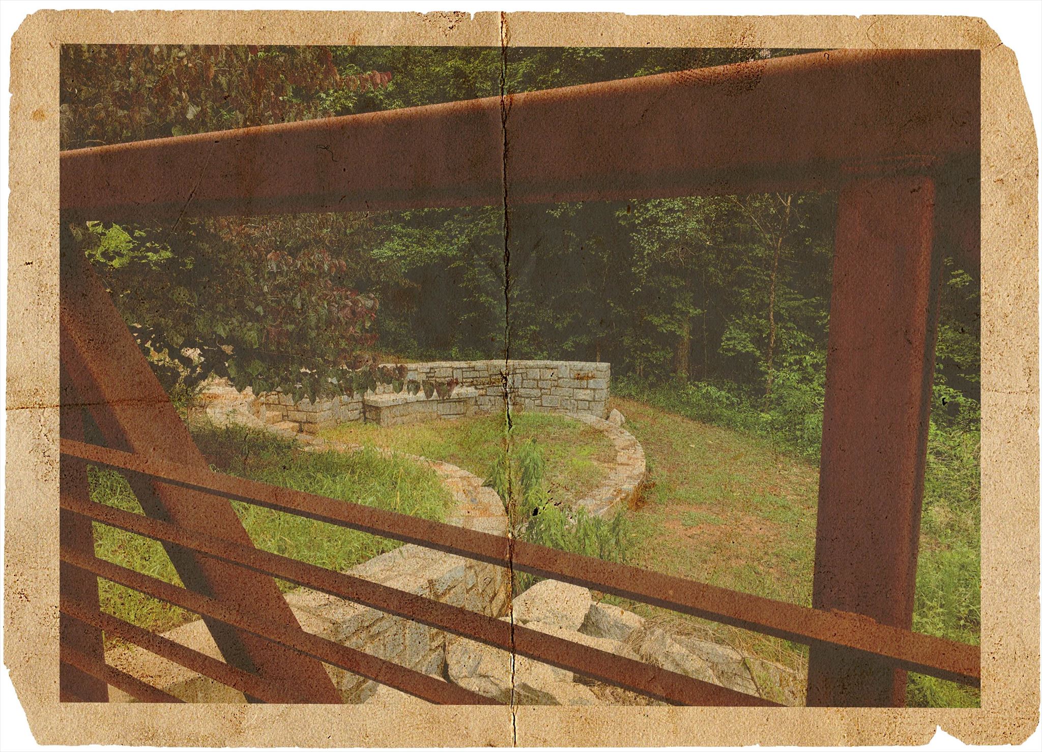
Snapshot taken from the bridge showing the sitting and viewing area
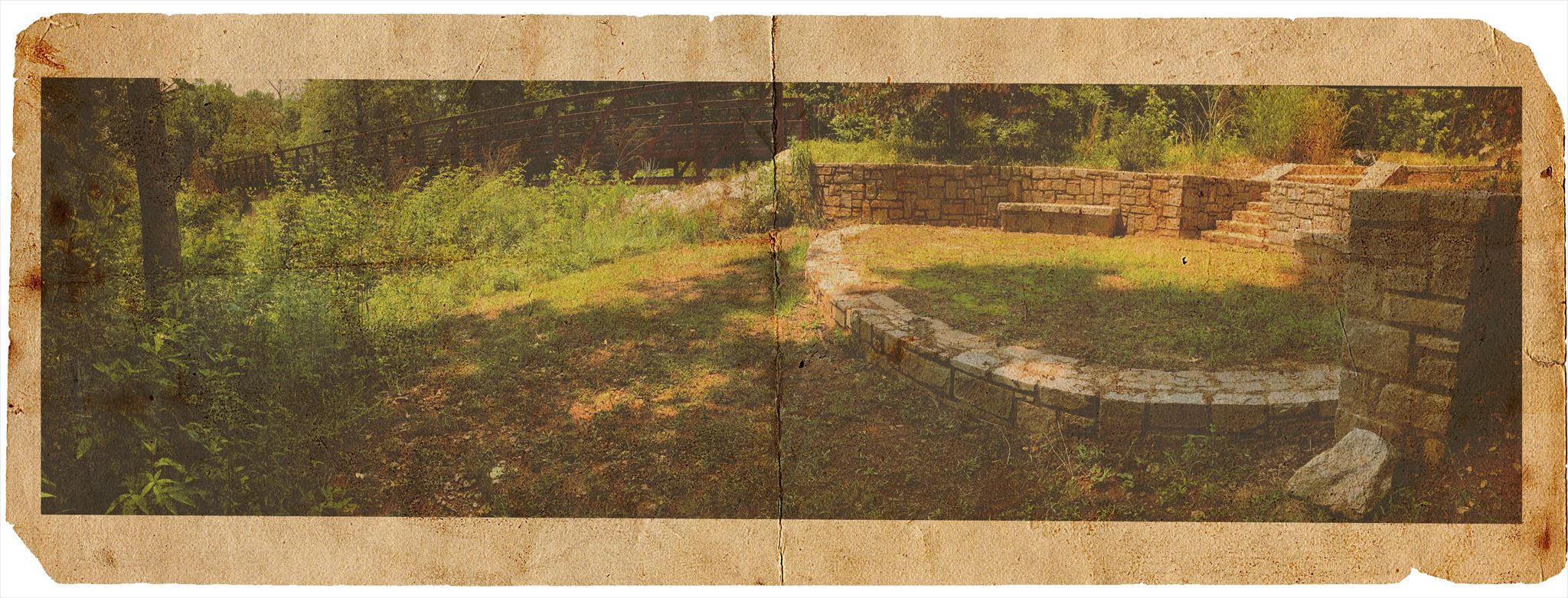
Snapshot taken from the sitting and viewing area with the bridge in the background
South River Stroll
This geocache is part of the South River Stroll (SRS) series within the Arabia Mountain National Heritage Area.
Following the path of the South River, this series highlights shaded trails, flowing water, trail connections, and the small stories tucked along the corridor. Some caches focus on ecology, while others reflect memorable features and landmarks found along the way.
As you continue along the South River Stroll, you may begin to notice how the river, bridges, paths, and overlooks all work together to create a richer journey through this landscape.
A Brief Cache History
This cache reflects the continued care and effort that help keep memorable locations like this active along the trail.
Over time, updates and improvements have helped carry the experience forward, allowing visitors to continue discovering this unique spot along the South River.
A special nod goes to Umwareagle for the design of the hide. The placement makes thoughtful use of the setting and ties nicely into the cache title, inviting cachers to look more closely at the relationship between the bridge, the overlook, and the natural stone features nearby.
If you study the photos carefully, you may notice that they offer more than scenic views. They also provide a subtle hint that connects the name of the cache to the hide itself.
Are You Ready to Find More Geocaches?
Come explore the
Arabia Mountain PATH
and earn trackable prizes along the way.
The
AMNHA Geo-Path
is a geocaching program spread across more than 30 miles of trail. Many geocaches are waiting to be discovered.
Download the passports
Geocaching Adventures Passport
Each cache is classified into one of the following series:
• Adventure Labs
• Arabia Mountain Adventures
• Geocaching 101
• GeoTour
• Lands Less Visited
• Lithonia's Historic Hike
• Panola Mountain Pathways
• Past and Present Passages
• South River Stroll
Completed the passports?
Choose one of the following options to claim your prize:
Scan and email the Arabia Alliance Team
Scan and mail to the Arabia Alliance office
Additional Links
Trail Maps and
Landmarks
Learn and
Activities
Tips for Hiking in the Summer Heat
Tips for Avoiding Ticks
Winter Hikes and Winter Wildlife
Waypoints and
Adding or Viewing Coordinates
Trails Map Type Option