
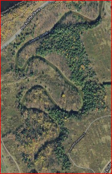
GREENS CREEK
If something has an asterisk at the end of it (*) then look to the bottom of the paragraph for a definition.
Meander
A meander, in general, is a bend in a sinous watercourse or river. A meander is formed when the moving water in a stream erodes the outer banks and widens its valley and the inner part of the river has less energy and deposits what it is carrying. A stream of any volume may assume a meandering course, alte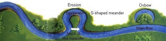 rnately eroding sediments from the outside of a bend and depositing them on the inside. The result is a snaking pattern as the stream meanders back and forth across its down-valley axis.
Greens Creek Meander
This is what has happened at Greens Creek. You can see it in the picture above; The twisting and turning of the creek. This here,is the result of natural factors and processes. The waveform configuration of Greens Creek is constantly changing. Once the channel begins to follow a path, the amplitude and concavity of the loops increase dramatically due to the effect of helicals flow* sweeping dense eroded material towards the inside of the bend, and leaving the outside of the bend unprotected and therefore vulnerable to accelerated erosion, forming a positive feedback loop**.
*Helicoidal flow is the cork-screw-like flow of water in a meander.
**Positive feedback is a process in which the effects of a small disturbance on a system include an increase in the magnitude of the perturbation
Landslides & Geology
Studies done on Greens Creek...
Studies on Greens Creek revealed that landslides occurred preferentially in slopes located on the outside of meander bends, and that they often recurred in the same slope after a period of ripening.
The creek drains northward into the Ottawa River and is the principle drainage route for the Mer Bleue Bog. A synthesis of borehole* logs in and around the Green’s Creek valley reveals that four major stratigraphic* sequences are commonly found overlying Paleozoic bedrock. In some areas the oldest sequence overlying the bedrock is a thin layer of till***. In other areas there is glaciofluvial**** sediment instead of till. These sediments are overlain by a fresh water varve sequence. A varve is an annual layer of sediment or sedimentary rock. This varve sequence usually contains silt and clay. The varve sequence at Greens Creek is generally two to eight meters thick.
*Borehole records are produced from a geologist's or surveyor's observations of the rock core extracted from the ground.
**Stratigraphy is a branch of geology which studies rock layers and layering.
***Till or glacial till is unsorted glacial sediment.
****Glaciofluvial: of, relating to, or coming from streams deriving much or all of their water from the melting of a glacier.
Quick Clay at Green's Creek...
The initial stages of and slides in the Green’s Creek valley appear to be connected to the upper facies* which is up to 12 m thick, and is interbedded with narrow silt layers. Geochemical analyses of borehole samples indicate that the two clay facies can be distinguished according to pore water chemistry; higher quantities of sodium and iron are found in the marine clay while there is more calcium and magnesium in the
upper clay. The upper clay facies is more sensitive than some other clay facies around Ottawa. it is generally recognized that the dramatic flow-like or “quick clay”** landslides are generated when the more sensitive clay is involved. (I suggest you read the definition of quick clay. It will help. Find it below this paragraph.)
*A metamorphic facies is a set of metamorphic mineral assemblages that were formed under similar pressures and temperatures.
**Quick Clay is a unique type of clay, with the tendency to change from a relatively stiff condition to a liquid mass when it is disturbed. When a mass of quick clay undergoes sufficient stress, however, it instantly turns into a flowing ooze, a process known as liquification. Less sensitive quick clay deposits can liquefy from an induced stress as simple as saturation by excess rainwater, while a highly sensitive deposit is mainly vulnerable to greater stresses such as earthquake vibrations or construction activities. Quick clay behaves this way because, although it is solid, it has a very high water content, up to 80%. The clay retains a solid structure despite the high water content, because surface tension holds water-coated flocs of clay together in a delicate structure. When the structure is broken by a shock, it reverts to a fluid state.
The Landslides...
Contemporary and ancient landslides have been studied within and around the Green’s Creek valley. The largest of these landslides is the Beacon Hill landslide, which involved approximately 1.5 million m3 of material.
From the inventory, landslides were classified into four types...
-simple rotational slides
-retrogressive rotational slides
-translational slides and,
-flows
In a simple rotational slide the surface of rupture is concave upward and the mass rotates along the concave shear surface. Simple rotational slides involve a single shear surface whereas retrogressive rotational slides involve multiple or successive shear surfaces. In a translational slide, the surface of rupture is a planar or gently undulatory surface. Translational slides tend to be shallow and are often referred to as sheet slides or surficial slides. Landslides classifed as flows exhibit signs of fluid-like movement. They may start as a rotational slide, but liquefaction of the displaced material quickly evacuates debris from the scar.
A total of 52 landslides were identifed between 1928 and 2001. The highest density of landslides occurred along Mud Creek followed by the lower and middle reaches of Green’s Creek. Very few landslides were observed in the upper reach of Green’s Creek beyond the
confluence with Mud Creek where slopes are much lower and bedrock is exposed in many areas above the level of the creek. A unifying characteristic of the landslides observed in the aerial photographs is their preferential occurrence in slopes situated on the outside of meander bends which is expected since flow impingement concentrates fluvial erosion at the outer bank.
This characteristic confirms previous reports
concerning the importance of fluvial erosion and oversteepening in setting up the geometric conditions for landsliding to occur in clay deposits.
Below is a Pie graph (mmmmm pie...) that shows the percentage of how many times each type of landslide occured out of all the landslides.
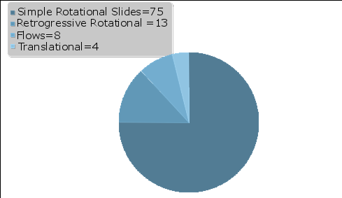
The prevalence of simple rotational slides supports the perception that most landslides are restricted to the upper weathered clay facies. However, the occurrence of four landslides classifed as flows in the early 1970s indicates that some failure surfaces may extend down to the sensitive marine clay.

<<p>
Discharge Rates
If you've been to my other earthcache, http://coord.info/GC4APH4, you might know how to calculate discharge rates. If not, you could of course read that cache page. Or this cache page, because I'll put it here as well. You can also read bout it at this link:
http://geography-site.co.uk/pages/skills/fieldwork/fluvial/disc.html
How to calculate the river discharge
(Average velocity):
The velocity of the water within a river channel varies according to depth and nearness to obstacles such as the bed, banks and boulders which generate friction and drag. If you have recorded the surface velocity, a good estimate of the average can be found by multiplying your surface value by 0.8. For example, a surface value of 3 meters per second would be converted thus...
Measured surface value x 0.8 = average velocity
3.0ms x 0.8 = 2.4 ms
If you have carried out a detailed survey of velocity throughout the cross-section, using a velocity meter ( flow vane ) you can plot your readings on graph paper and work out the average velocity from that. Either way, don't forget to ensure that for the final discharge reading you use the correct units for area and time - meters and seconds.
Cross-sectional area Now for the cross-sectional area. Having recorded all your depth data in the field you will probably be intending to plot it on graph paper to produce a cross-section diagram. Once this has been drawn it is possible to find the area simply by counting the number of squares in the 'wet' part of the diagram. This works quite well for small streams but the number of squares on the graph paper rapidly goes into the hundreds and even thousands. Keeping an accurate record of which ones you have counted is difficult without marking them on the actual diagram. This may not be desirable if you want to display the diagram afterwards.
Questions to answer
In order to log this as a find, there are a few questions you have to answer. There are different coordinates for each question, and lots of the walking will be off trail. You may need to wade into the creek at some points (be careful). All these factors make up the high terrain rating. I have placed all these waypoints near caches, so there's something else to do out there while you answer the questions. Each question has it's own set of coorinates, and the coordinates are all entered as "Reference Waypoints" for easy downloading. Email the answers to me.
LOGS WITH SPOILERS/ANSWERS WILL BE DELETED WITHOUT NOTICE!
Send me each answer by Email:
Question #1. - Posted coordinates: N 45° 27.696 W 075° 34.611
Q: Estimate the width of the creek at the coordinates.
Question#2. - Stage 2 (N 45° 27.487 W 075° 34.636)
Q: Calculate the discharge rate of the creek.
I showed you how to do this in the last part of the text. Use the rapids by GCWGEH, Lower Rapids of Green's Creek by bibbits. The rapids aren't too too strong here, but either way; IF you have to go wading, be careful. This is easier to do while wading, but safer to do without wading. My suggestion is bring a friend out there with you!
Question#3 -
Q: Walking around the creek do you think that this meander could produce an oxbow? If landslides similar to the ones previously recorded continue, do you think they could influence the meander? Remeber what you read in paragraph before the pie chart (The text is boldfaced, as it is important).
But really, the most important thing, I guess, is that you have fun out there. This is why I placed it nearby two other caches.
Have fun, Happy hunting!
Greg
