The Geologic story of Scotts Bluff
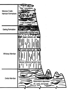
If you were to drill a well near the North Platte River, upon reaching a depth of 250 feet, you would find evidence that ancient shallow seas covered the Great Plains until 70 million years ago. A sedimentary rock called shale, which formed at the bottom of that ancient sea, is now buried below the promontories of Scotts Bluff. Geologists have named this formation the Pierre Shale. The sea receded as the Great Plains began to uplift along with the uplift of the Rocky Mountains. Meandering rivers and eastward blowing winds then began to carry weathered sand and silt from the newly formed mountains. The materials left by these rivers became the Orella Member of the Brule Formation in the White River Group (see generalized cross-section). This layer can be seen in the badlands section of the park.
Next in the geologic story of Scotts Bluff, huge volcanic eruptions occurred in what is now south-central and western Colorado, beginning about 33 million years ago. These eruptions were similar to the violent eruption of Mt. Saint Helen in the state of Washington in 1980. Eastward blowing wind currents carried the volcanic ash to western Nebraska. This ash is found in the Whitney Member of the Brule Formation, mixed with silt. Two distinct ash layers are also found in the Whitney Member. The lower ash layer likely records one enormous eruption about 31 million years ago. Both of these ash layers are visible about half way up Eagle Rock.
The Gering Formation of the Arikaree Group records the development of sand dunes across western Nebraska. This formation can be viewed in Eagle Rock at the change from a massive cliff to the more layered appearance higher up. Cross-sections of Gering Formation dunes can be seen on the Saddle Rock Trail, in the Monroe Creek-Harrison Formation, the so-called “pipy” concretions of hard calcium carbonate stick out of the rock layers. The dunes and concretions scattered together among the layers indicate cyclic changes in climate about 20 million years ago. During dry periods, the sand dunes formed and moved across the plains. During wetter periods, ground water moved through some of the sand and calcium carbonate cemented the sand into the concretions.
About 5 million years ago, renewed uplift of the plains and decreasing amounts of sediment allowed rivers and winds to begin to erode the very sediment they had originally deposited. The uplift of the plains caused the rock layers to crack, further weakening them. In some areas, the layers containing the “pipy” concretions were not cracked, and these layers formed a protective cap over soft rock below. These areas now stand up from the landscape as the bluffs we see today. Before this uplift and erosion, the plains here were at least as high as the present top of the bluffs. Since that time, between 400 and 800 feet of sedimentary rock has been removed, and that process continues today.
The Book of Scotts Bluff
Ancient seas, streams, sand dunes and volcanic eruptions have all worked to produce the layers making up Scotts Bluff. At one time, water and wind were the forces which deposited the fine silt and ash which built up the plains until five million years ago. Today, the same forces are working to tear down the bluffs. Perhaps in another few million years there will be no bluffs at all. Water and wind will be left to begin, perhaps, another cycle of deposition.
It has taken nearly 70 million years to create the landscape at Scotts Bluff National Monument. Walking off of paved trails on the summit of Scotts Bluff can artificially increase the wearing away of the rocks by trampling protective plant cover. Walking off-trail on the summit is also dangerous, and is prohibited. With proper protection and careful use, the bluffs can remain essentially unchanged for your children and future generations to enjoy.
- You are now standing at the William Henry Jackson Campsite. Looking to the East you can see Eagle Rock and Sentinel Rock. How many ash layers (white volcanic ash) can you see exposed?
- On your hike here did you see evidence of manmade erosion or improvements? What were they?
- How many geologic formations are exposed on Eagle Rock?
- Which formation is exposed on Sentinel Rock?