
“The Ste. Genevieve Fault Zone crosses the northeast flank of the Ozark Dome in southeastern Missouri and extreme southern Illinois. The surface trace of faulting trends southeast and is approximately 120 miles ... long. Major displacements are as much as 3,000 feet ... downward, which is cut by one or more high-angle reverse faults. Smaller high-angle normal and reverse faults are found on both sides of the main zone. Both ends the Ste. Genevieve Fault Zone dies out into a monocline. ....... small earthquakes occur from time to time along the Ste. Genevieve Fault Zone. Many faults in the zone appear capable of slipping under the current stress regime of east-northeast to west-southwest horizontal compression. It is concluded that the zone may continue to experience small earth movements, ...” (Illinois State Geological Survey, Contract/Grant Report 1985-3, 94 p.)
Seeing as how we can physically see the fault in this area we are going to observe and evaluate this area.
An earthquake on January 15, 1945, gave geologist some evidence that maybe the Ste. Genevieve fault zone is still seismically active. It, together with previous similar minor activity along the fault, may be associated with a deep-seated fault system near the physiographic margin of the Ozarks or with deep-seated fractures on the southeastern flank of the uplift.
Type of rock here
This fault line runs through St. Peter Sandstone. St. Peter Sandstone is an Ordovician formation (485.4-443.4 Million years ago) in the Chazyan stage of the Champlainian series. This sandstone originated as a sheet of sand in clear, shallow water near the shore of a Paleozoic sea and consists of fine-to-medium-size, well-rounded quartz grains with frosted surfaces. The extent of the formation spans north-south from Minnesota to Missouri and east-west from Illinois into Nebraska and South Dakota.

Different types of Faults
A close look at faults helps geologists to understand how the tectonic plates have moved relative to one another.

Normal faulting – where the crust is being pulled apart, normal faulting occurs, in which the overlying (hanging-wall) block moves down with respect to the lower (foot wall) block.
Reverse faulting – where the crust is being compressed, reverse faulting occurs, in which the hanging-wall block moves up and over the footwall block – reverse slip on a gently inclined plane is referred to as thrust faulting.
Dip-slip movement—Slip of one fault block, relative to the other block, by movement parallel to the dip of the fault. On any inclined surface, such as a fault in the Houston area, it is possible to draw an imaginary horizontal line, termed the strike of the fault, and to draw a second line perpendicular to the strike, termed the dip line. The angle by which the dip line deviates from horizontal is the dip of the fault; it corresponds to the inclination of the fault in nonscientific terms. If movement of one fault block relative to the other block occurs parallel to the dip line, it is termed dip-slip movement.
Downthrown side—The side of a fault that appears to have moved downward relative to the other side.
Upthrown side—The side of a fault that appears to have moved upward relative to the other side. (USGS)
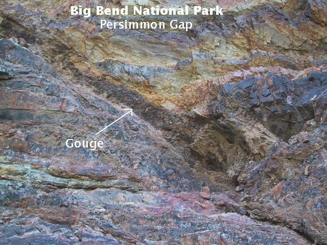
Nature’s crusher
Fault gouge is crushed and ground-up rock produced by friction between the two sides when a fault moves. (USGS)
Source: Web
You can see some Fault gouge here in the fault line.
**Logging requirements**
DO NOT POST ANSWERS IN YOUR LOG.
Send the following answers to me via email.
You can get a good view of this fault line while parked on the “South bound on ramp of I-55”
- The text "GC55VNY STE Genevieve fault system" on the first line
- What is the primary color of sandstone under the bridge on the East side of I-55?
- What is the primary color of sandstone showing at waypoint “Southside”?
- What is the elevation at the posted cords?
- At waypoint “Southside” the high point elevation is 518 feet, which side is the down-thrust side and which side is the up-thrust side?
| I have earned GSA's highest level: |
 |