St. Peter Sandstone
St. Peter Sandstone is an Ordovician formation (485.4-443.4 Million years ago) in the Chazyan stage of the Champlainian series. This sandstone originated as a sheet of sand in clear, shallow water near the shore of a Paleozoic sea and consists of fine-to-medium-size, well-rounded quartz grains with frosted surfaces. The extent of the formation spans north-south from Minnesota to Missouri and east-west from Illinois into Nebraska and South Dakota.

During the Ordovician, the southern continents were collected into a single continent called Gondwana. Gondwana started the period in equatorial latitudes and, as the period progressed, drifted toward the South Pole. Early in the Ordovician, the continents Laurentia (present-day North America), Siberia, and Baltica (present-day northern Europe) were still independent continents (since the break-up of the supercontinent Pannotia earlier), but Baltica began to move towards Laurentia later in the period, causing the Iapetus Ocean to shrink between them. The small continent Avalonia separated from Gondwana and began to head north towards Baltica and Laurentia. The Rheic Ocean between Gondwana and Avalonia was formed as a result.
A major mountain-building episode was the Taconic orogeny that was well under way in Cambrian times. In the beginning of the Late Ordovician, from 460 to 450 Ma, volcanoes along the margin of the Iapetus Ocean spewed massive amounts of carbon dioxide into the atmosphere, turning the planet into a hothouse. These volcanic island arcs eventually collided with proto North America to form the Appalachian Mountains. By the end of the Late Ordovician these volcanic emissions had stopped. Gondwana had by that time neared or approached the pole and was largely glaciated.
Commercial use
St. Peter sandstone, also called "Ottawa Sand" in commercial applications, has a relatively uniform size and shape for each grain. It is used for the manufacture of glass, for filter and molding sand, and for abrasives. Its purity is especially important to glassmakers. It is also important as a "frac sand" in oil and gas drilling – loose sand is pumped in a liquid mix under high pressure into an well where the sand grains wedge into and hold open any fractures in the rock, enhancing the extraction of hydrocarbons. The uniform particle size also makes the sand useful for laboratory experiments.
Erosion
Erosion is the process by which soil and rock are removed from the Earth's surface by natural processes such as wind or water flow, and then transported and deposited in other locations.
In this particular area at GZ, Water has caused most of the Erosion here. Springs are both caused by erosion and causes of erosion.
Types of Erosion:
Splash Erosion: Small soil particles are detached and sent airborne through the impact of raindrops on soil.
Sheet Erosion: Raindrops break apart the soil structure and it's moved down-slope by water that flows overland as a sheet rather than definitive channels. This occurs frequently during cloud bursts.
Rill Erosion: This process develops small, short-lived, concentrated flow paths. These paths create a sediment source and delivery system for hill-slope erosion. Areas where precipitation rates exceed soil infiltration rates are more prone to this type of erosion.
Gully Erosion: Water flows in narrow channels during or directly following heavy rains or melting snow. The gullies can erode to considerable depths.
Valley or Stream Erosion: Continual water flow alongside land (along a linear feature) creates this type of erosion. It extends downward, deepening a valley, and head-ward, extending the valley into the hillside. This occurs most frequently in times of flooding.
Bank Erosion: Over time, banks of rivers and streams are naturally worn down.
Freezing and thawing: Cold weather causes water trapped in tiny rock cracks to freeze and expand, breaking the rock into several pieces.
Wind erosion is a major geomorphological force, especially in arid and semi-arid regions. Wind erosion is of two primary varieties: deflation, where the wind picks up and carries away loose particles; and abrasion, where surfaces are worn down as they are struck by airborne particles carried by wind.
Mass movement is the downward and outward movement of rock and sediments on a sloped surface, mainly due to the force of gravity. Mass movement is an important part of the erosional process, and is often the first stage in the breakdown and transport of weathered materials in mountainous areas. It moves material from higher elevations to lower elevations where other eroding agents such as streams and glaciers can then pick up the material and move it to even lower elevations. Mass-movement processes are always occurring continuously on all slopes; some mass-movement processes act very slowly; others occur very suddenly, often with disastrous results.
Urbanization has major effects on erosion processes—first by denuding (means = strip bare) the land of vegetative cover, altering drainage patterns, and compacting the soil during construction; and next by covering the land in an impermeable layer of asphalt or concrete that increases the amount of surface runoff and increases surface wind speeds. Much of the sediment carried in runoff from urban areas (especially roads) is highly contaminated with fuel, oil, and other chemicals. This increased runoff, in addition to eroding and degrading the land that it flows over, also causes major disruption to surrounding watersheds by altering the volume and rate of water that flows through them, and filling them with chemically polluted sedimentation. The increased flow of water through local waterways also causes a large increase in the rate of bank erosion.
Mining is the extraction of valuable minerals or other geological materials from the earth.
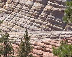
Bedding types
Sedimentary Bedding
“STRATIFICATION refers to the way sediment layers are stacked over each other” (University)
Cliffs such as this can often tell you how the sediment making up the rock was deposited prior to diagenesis. All you have to do is look at the rock’s structure and appearance for a characteristic known as bedding. There are two types of bedding, graded and cross-bedding.
Graded Bedding is seen when the structure of the sedimentary rock appears to take on a horizontal sheet-like appearance. That is to say, the rock appears to be “layered” like pancakes, and often has larger particles underlying smaller ones. The term “graded” comes from the fact that the particles arrange themselves by relative size as they settle. Often there may be numerous beds of varying depth stacked horizontally on top of one another. Sometimes the grades or strata may be very thin and not easily seen. But color, amount of erosion in exposed surfaces, or even slight textural changes in the rock, may signify a change from one bed to another. (University)

Cross-bedding occurs when sediments are laid down at angles or arcs, sometimes cutting into one another, and not necessarily in even “layers”. This type of bedding often occurs in areas where a sandbar or dune existed prior to diagenesis. (University)
**Logging requirements**
DO NOT POST ANSWERS IN YOUR LOG.
Send the following answers to me via email.
- The text "GC55W85 Saint Peter" on the first line
- Name at least two types of erosion that you can see happening to this cliff area?
- What is the elevation here?
- The high point of the cliff here has an elevation of 725 feet how high is this cliff of St. Peter sandstone?
- There are three old mine entrances seen in the cliff here what colors are present in the St. Peter sandstone?
- What kind of bedding do you see in the cliff?
| I have earned GSA's highest level: |
 |
Sources and credits
Owen, D.D., 1847, Preliminary report of the geological survey of Wisconsin and Iowa: U.S. Gen. Land Office Rept., 1847, p. 160-173.
Stauffer, C. R., 1934, Type Paleozoic sections in the Minnesota Valley: Jour. Geology, v. 42, p. 337-357.